Page 106
Searches the whole library — filter by sim & category on the results page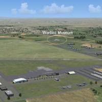
A California layout adds Estrella Warbird Museum at PRB and animates radar at SMX, VBG, and SBA, with new lighting for the PRB area. Credits go to Al Wheeler, with radar and lighting contributions …
 United States of America
Steve Hess changes the parking configuration at Pease International Tradeport (KPSM) in New Hampshire to mirror Pease AFB days, restoring a layout associated with the former base. The description n…
United States of America
Along the Durban coast in South Africa lies the Umhlanga Rocks area, described as a popular holiday destination, and Greg Olfin is credited as the creator, establishing the geographic focus and aut…
 South Africa
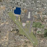
Two BGL files KMFE_ADE_BCCRWe2_CVX and KMFE_ADE_BCCRWe2 accompany KMFE v2.2 near McAllen in Texas, using ADE 1.37 and Stock FSX library objects as the base, and satellite imagery guides taxiway and…
United States of America
An airport upgrade at KAVP in Pennsylvania updates aprons and taxiways to reflect new construction, adds a terminal with jetways, and moves the control tower alongside a parking garage and hangars.…
United States of America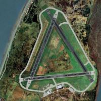
Walney Island airfield (EGNL) in the UK has a history dating to World War I as a Royal Navy Air Station. It blends with Horizon GenX Photo imagery and GenX Mesh and requires Runway12 library plus t…
 United Kingdom
Custom photoreal 3D buildings populate New Zealand's Mount Ruapehu, by Michael Allen-Andrews. Designed with SP1 SP2 SDK and optimized to align with a 20 meter mesh and a vector landclass add-on, it…
 New Zealand
Galway Airport (EICM) in Ireland receives a freeware enhancement by Padraic O hEithir that adds updated parking, a terminal, a fire station, the south apron, and the Galway flying club. It comes fr…
 Ireland
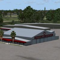
Craig Municipal Airport in Jacksonville, Florida gains a revised Craig Air Center FBO depiction by Art Poole. The toolkit is built with LibraryCreatorXML, centers on Airport_Buildings_AP.bgl, an ob…
United States of America
Leconfield UK (EGXV) presents a base layout featuring the Defence School of Transport and E Flight 202 Sqdn Air Sea Rescue with Sea King helicopters. It requires multiple libraries, including raf_o…
United Kingdom
An autogen overlay for Barbers Point, v1.0, sits atop Hawaii photographic coverage and begins at PHJR with static military aircraft, helicopters, and birds, then extends west to Barbers Point Harbo…
United States of America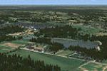
Karksi in Estonia presents photoreal terrain around an airstrip with a sloping grass runway measuring 700 by 20 meters. The author Paavo Pihelgas is credited for this work, aligning the details to …
 Estonia
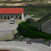
Victor Pinto presents MPCH, the Changuinola airport in Bocas del Toro, Panama. The component requires VLC libraries to function and notes MPCH as the identifying code for this Panamanian site. The …
 Panama
By Nicholas Cole, modifications target the main east coast airports of Australia, including YBBN, YTRE, YAMB, and YMAV as an airshow variant. YBBN receives a new runway; YRED adds buildings and sta…
 Australia
Deenethorpe in the United Kingdom serves the USAAF Eighth Air Force as Station 128, housing the 401st Bombardment unit (Heavy) with tail code Triangle-S and squadrons 612th, 613th, 614th, and 615th…
United Kingdom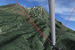
Mt Taranaki/Mt Egmont in New Zealand spans 30x40-kilometre, using NZ aerial imagery at 2.5 metres per pixel with a blend mask smoothing the edge between photoreal and default land. Autogen produces…
New Zealand
Clarion, PA Rhea Airport now appears among the included airports, and refuelling spots appear at most locations. The roster tallies 46 airports, or 48 when counting Waynesboro and the closed Stultz…
United States of America
Dick Kittredge creates a Middletown, Connecticut placement along the Connecticut River, just south of Hartford, highlighting a localized aviation area. The MiddletownCT.bgl file encodes the placeme…
United States of America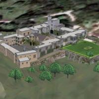
By Chris Brown, Haddon Hall in Derbyshire, UK is aligned with Generation X, volume 3 and uses a 2.4 m/pixel terrain mesh at 5 m/pixel. The northwest side remains approximate in appearance due to re…
United Kingdom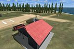
The Tresco heliport on the Scilly Isles in Cornwall, UK carries ICAO code EGHT and is credited to Harry Patten. A single bgl file encodes the Tresco heliport data and bears the creator's name Harry…
United Kingdom