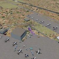
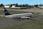
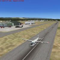
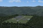
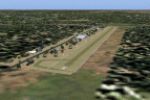
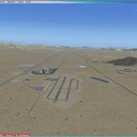
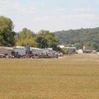
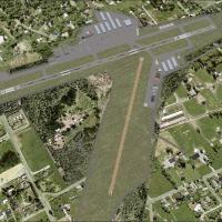
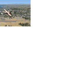
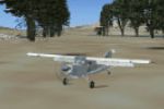
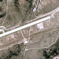
United States of America

Page 38

No image available.

First Flight Airport

Wright Brothers’ First Flight Airport KFFA scenery for Microsoft Flight Simulator X improves the AFCAD by re-aligning gates, adding authentic parking stands, and rebuilding taxiway links, mirroring current FAA charts for this Outer Banks general-aviation field in North Carolina, USA; the compact add-on integrates with default terrain, preserves runway 03/21 markings, and enables AI traffic flow.

File Size
2.59 KB
Total Downloads
201
Preview screenshot

Casa Grande Municipal Airport

FSX rendition of Casa Grande Municipal Airport (KCGZ) introduces a detailed AFCAD, animated ground service vehicles, custom parking stands and photoreal objects across the Arizona desert apron, accompanied by tuned night lighting and seamless compatibility with MegaCity Phoenix, Ultimate Terrain X, Ground Environment X, Real Environment Extreme and MyTraffic X.

File Size
385.81 KB
Total Downloads
200
Star Rating
3/5
Screenshots
2
Preview screenshot

Saratoga County Airport 5B2 Scenery Fix

Focused update for Microsoft Flight Simulator X users, this ADE-based AFCAD revision tunes Saratoga County Airport 5B2 in upstate New York, rebuilding taxi node links and parking spot codes so AI general-aviation traffic departs and arrives without errant back-tracking, restoring proper ramp geometry for accurate GA operations.

File Size
6.67 KB
Total Downloads
200
Star Rating
1/5
Screenshots
2
Preview screenshot

Deer Valley Resort

Between the Mogollon Rim and Roosevelt Lake, this FSX freeware scenery positions a private Deer Valley Resort fly-in near Grapevine, Arizona, adding a short dirt strip, dock, helipad, custom lodges, animated amusement rides and shoreline detail that complements VFR bush flying, floatplane operations and casual GA sorties across the Tonto Basin.

File Size
4.22 MB
Total Downloads
199
Screenshots
2
Preview screenshot

Springfield Massachusetts

Serving Springfield, Massachusetts along the Connecticut River, this FSX flight-sim scenery download inserts realistic downtown assets, the Big E fairgrounds, and surrounding New England landmarks into the terrain mesh, optimized for UT USA landclass. Crafted via Flight1 Instant Scenery, the modest add-on aids VFR navigation, pattern practice, and low-altitude sightseeing.

File Size
5.31 MB
Total Downloads
199
Screenshots
2
Preview screenshot

AFCAD Modification To The Stock KRDU

Raleigh-Durham International Airport (KRDU) for Microsoft Flight Simulator X receives a 2009-era AFCAD overhaul by Kambiz Agazi, adding precise gate allocations, realigned taxiways, updated ILS/RNAV coding, refined cargo and GA aprons, corrected landclass, and adaptive lighting calibrated for AI traffic solutions such as MyTraffic X and WOAI, remaining compatible with FSX SP2, UTX USA, and high-resolution mesh.

File Size
2.33 MB
Total Downloads
197
Screenshots
10
Preview screenshot

Berkeley Marina

Targeting the Berkeley, California coastline, this FSX add-on populates the marina with AI boats, textured jetties, dedicated seaplane slips, a refueling berth and animated birdlife, relying on at least Sparse autogen to integrate smoothly with default mesh and the Living World engine for enhanced waterfront activity.

File Size
1.83 MB
Total Downloads
196
Screenshots
16
Preview screenshot

Canyonlands

Targeted at the Utah subset, this FSX add-on retunes Canyonlands and Arches photoreal coverage with geo-corrected KCNY Moab, U43 Monticello, and UT53 Sky Ranch, supplying refined AFCAD geometry, calibrated runway elevations, and coordinated AI BGL traffic for seamless VFR and IFR procedures across the red-rock plateau.

File Size
11.89 MB
Total Downloads
196
Screenshots
2
Preview screenshot

Austin Executive Airport

Covering Austin Executive Airport KEDC in Texas, this FSX add-on replaces the obsolete 6R4 layout with a present-day airfield diagram, revised taxiway geometry, corrected runway length, custom AFCAD and a provisional ILS, giving corporate-jet and GA flyers accurate approach fixes and realistic parking positions under the MS Flight Simulator X engine.

File Size
5.54 MB
Total Downloads
196
Screenshots
3
Preview screenshot

Custer County Airport

KCUT Custer County Airport scenery for Microsoft Flight Simulator X refreshes this South Dakota general-aviation strip in the Black Hills, bringing corrected runway geometry, revised taxiways, default-library hangars, photoreal ground polys and animated wildlife, a short hop from Mount Rushmore; fully compatible with FS Genesis terrain mesh, Ultimate Terrain X and advanced weather engines.

File Size
835.98 KB
Total Downloads
195
Star Rating
3/5
Screenshots
13
Preview screenshot

Dubuque Regional Airport

Microsoft Flight Simulator X pilots seeking a tidy Midwest hub will find this Dubuque Regional Airport scenery refresh useful: correct airline gate coding, updated parking nodes, cargo apron tweaks, custom FBO and repair hangar, new terminal, fire station and static GA traffic, compiled via ADE for seamless U.S. terrain blending.

File Size
182.67 KB
Total Downloads
194
Star Rating
5/5
Screenshots
13
Preview screenshot

Austin-Bergstrom International Airport

Updating the stock FSX rendition, this Austin-Bergstrom International (KAUS) scenery for Texas introduces a chart-verified ADE-9X AFCAD, accurate taxiway geometry, re-numbered jetways, FBO and cargo stands, overflow GA parking, Jim Dhaenen’s LED lighting, T-hangars and revised runway data, supplying realistic gate assignments for airline, military and corporate operations.

File Size
11.35 MB
Total Downloads
194
Screenshots
13
Preview screenshot

Erie International (Tom Ridge Field) Update 3

FSX refinement of Erie International Airport (KERI/Tom Ridge Field) in Pennsylvania introduces the 2012 runway-extension layout, corrects displaced threshold for runway 6, realigns taxiway B and resolves traffic spawning at the former 24 threshold; built exclusively with default library objects via ADE9X for seamless compatibility with U.S. regional scenery stacks.

File Size
288.66 KB
Total Downloads
192
Screenshots
1
Preview screenshot

Pocono Mountains Municipal

FSX users flying the United States/Pennsylvania set will find Pocono Mountains Municipal Airport (KMPO) represented with an updated airport layout file, 5,001-ft asphalt runway 13/31, revised taxiway geometry, accurate field elevation, EZ-Scenery objects and default GA traffic, enabling credible pattern work and regional VFR routes across Monroe County’s plateau terrain.

File Size
738.75 KB
Total Downloads
191
Star Rating
3/5
Screenshots
2
Preview screenshot

Philadelphia Municipal Airport

KMPE Philadelphia Municipal Airport scenery refresh adds corrected runway 18/36 dimensions, updated taxiway geometry, enhanced ramp lighting and region-appropriate autogen around Neshoba County, delivering a low-impact FPS upgrade ideal for GA circuits, pattern work and cross-country hops across Mississippi in FSX and Prepar3D compatibility mode.

File Size
313.04 KB
Total Downloads
191
Star Rating
1/5
Screenshots
4
Preview screenshot

Mount Rainier

Set against Washington State’s rugged Cascade skyline, this FSX add-on installs a fictional 13,000-ft elevation airstrip hewn into Mount Rainier’s crater rim, complete with custom terrain mesh, seasonal textures, and dynamic shadows for demanding high-density-altitude operations and realistic mountain-wave turbulence during VFR or IFR practice.

File Size
653.45 KB
Total Downloads
190
Screenshots
1
Preview screenshot

San Luis County Regional

San Luis County Regional Airport KSBP receives a concise overhaul for Microsoft Flight Simulator X, aligning runway, taxiway and apron geometry with up-to-date satellite imagery and employing stock library objects for hangars, GA ramps and support structures; well-suited to VFR pattern work or IFR coastal legs around Southern California, the package is authored in Airport Design Editor and delivered as lightweight BGL files.

File Size
282.74 KB
Total Downloads
190
Screenshots
1
Preview screenshot

Redding Municipal Airport

Pilots planning hops between NorCal airfields can load this KRDD AFCAD to gain geospatially correct runway geometry, revised taxiway signage, a newly carved northeast GA ramp, and default-library static clutter, all compiled via ADE into clean BGL/CVX layers tuned for stock Flight Simulator X terrain.

File Size
244.94 KB
Total Downloads
189
Star Rating
4/5
Screenshots
1
No image available.

Elmira/Corning Regional Airport

Flight-sim pilots flying Microsoft Flight Simulator X around New York’s Southern Tier will find this scenery upgrade for Elmira/Corning Regional Airport (KELM) useful; the package refines aprons, taxiway geometry and service roads, introduces a purpose-built terminal with jetways, an updated tower, airline-coded gates, fire station, plus stock-library vehicles and static aircraft that round out ramp activity.

File Size
10.74 KB
Total Downloads
189
Screenshots
1
Preview screenshot

Palm Beach County Park Airport

KLNA – Palm Beach County Park Airport for Microsoft Flight Simulator X updates this South Florida GA strip with re-drawn aprons, corrected taxiway geometry, bespoke hangars, refined terrain mesh and adjusted landclass, all compiled by Art Poole as a freeware add-on that balances frame-rate efficiency with Very Dense object settings.

File Size
354.54 KB
Total Downloads
189
Screenshots
43