Terminal Procedures

KCMH — John Glenn Columbus Intl

COLUMBUS, OH · 27 FAA charts · cycle 6 Aug 2026

FAA CMHElevation 815 ft2 runwaysLongest 10,114 ftToweredFuel 100, Jet A-1+Volume EC-2Not for navigation
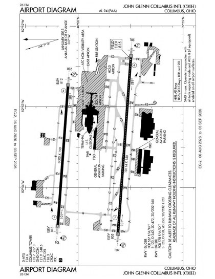
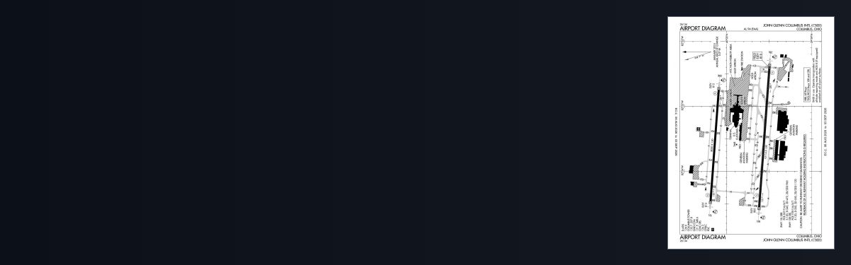
KCMH airport diagram — runways, taxiways and ramp layout
KCMH airport diagram The official FAA airport diagram — runways, taxiways, ramp layout and hold-short positions. Download PDF

14 published instrument approaches: 6 ILS approaches, 8 RNAV (GPS), serving 4 runway ends.

All 27 KCMH charts in one download Every approach, departure, arrival and minimums page for this airport, sorted into folders, as a single ZIP. Taken one at a time on the free tier, 27 charts is roughly 3 min of downloading — they queue one behind another.
PRO members only

Instrument approach procedures

ChartAmendment
ILS OR LOC RWY 10L chart previewILS OR LOC RWY 10L20PDF
ILS OR LOC RWY 10R chart previewILS OR LOC RWY 10R10PDF
ILS OR LOC RWY 28L chart previewILS OR LOC RWY 28L31PDF
ILS OR LOC RWY 28R chart previewILS OR LOC RWY 28R5PDF
ILS RWY 10R (SA CAT I - II) chart previewILS RWY 10R (SA CAT I - II)10PDF
ILS RWY 28L (SA CAT I - II) chart previewILS RWY 28L (SA CAT I - II)31PDF
RNAV (GPS) Y RWY 10L chart previewRNAV (GPS) Y RWY 10L4PDF
RNAV (GPS) Y RWY 10R chart previewRNAV (GPS) Y RWY 10R4PDF
RNAV (GPS) Y RWY 28L chart previewRNAV (GPS) Y RWY 28L4PDF
RNAV (GPS) Y RWY 28R chart previewRNAV (GPS) Y RWY 28R3APDF
RNAV (RNP) Z RWY 10L chart previewRNAV (RNP) Z RWY 10L4PDF
RNAV (RNP) Z RWY 10R chart previewRNAV (RNP) Z RWY 10R4PDF
RNAV (RNP) Z RWY 28L chart previewRNAV (RNP) Z RWY 28L2APDF
RNAV (RNP) Z RWY 28R chart previewRNAV (RNP) Z RWY 28R2PDF

Arrival procedures (STAR)

ChartAmendment
CBUSS TWO (RNAV) chart previewCBUSS TWO (RNAV)PDF
CBUSS TWO (RNAV), CONT.1 chart previewCBUSS TWO (RNAV), CONT.1PDF
CLPRR THREE (RNAV) chart previewCLPRR THREE (RNAV)PDF
CLPRR THREE (RNAV), CONT.1 chart previewCLPRR THREE (RNAV), CONT.1PDF
DUBLN ONE (RNAV) chart previewDUBLN ONE (RNAV)PDF
DUBLN ONE (RNAV), CONT.1 chart previewDUBLN ONE (RNAV), CONT.1PDF
JAKTZ TWO (RNAV) chart previewJAKTZ TWO (RNAV)PDF
JAKTZ TWO (RNAV), CONT.1 chart previewJAKTZ TWO (RNAV), CONT.1PDF
SCRLT TWO (RNAV) chart previewSCRLT TWO (RNAV)PDF
SCRLT TWO (RNAV), CONT.1 chart previewSCRLT TWO (RNAV), CONT.1PDF

Takeoff and alternate minimums

ChartAmendment
TAKEOFF MINIMUMS chart previewTAKEOFF MINIMUMSPDF
ALTERNATE MINIMUMS chart previewALTERNATE MINIMUMSPDF

Minimums pages cover a whole volume, so the same document is shared by every airport in it.

KCMH airport information

Control tower
Yes
Attendance
Continuous
ARTCC
Indianapolis Center
Flight service
Dayton
NOTAM facility
CMH (NOTAM-D available)
Magnetic variation
7W
Beacon
White-green (lighted land airport), sunset to sunrise
Wind indicator
Yes
ARFF index
Index C
Fuel
100, Jet A-1+
Airframe service
Major
Powerplant service
Major
Bottled oxygen
High/low
Parking
Tie-downs
Landing fee
Yes
Customs
Landing rights airport
Activated
October 1937
Airport area
2,265 acres
Ownership
Publicly owned
Sectional
Cincinnati
Last FAA inspection
2025-08-13

From the FAA NASR 28-day subscription, cycle 6 Aug 2026.

KCMH radio frequencies

ServiceFrequencyCall sign
UNICOM122.95
Tower132.7Columbus
Ground121.9Columbus
Clearance delivery126.3Columbus
ATIS124.6Columbus
Approach125.95280-099134.0100-279Columbus
Emergency121.5Columbus

Civil VHF frequencies from the FAA NASR 28-day subscription. Discrete sector and military frequencies are not listed.

Runways

10,114 × 150 ft10R28L8,000 × 150 ft10L28RN3,000 ft
Runway layout at KCMH, drawn to scale from FAA published runway-end coordinates and true alignments. Runways served by an ILS are highlighted.
RunwayLengthWidth SurfaceLighting
10R/28L10,114 ft150 ftAsphalt GoodHigh intensity
  10R 94°TILS/DME · PAPI (4-box) 3° · MALSR approach lighting
  28L 274°TILS/DME · PAPI (4-box) 3° · MALSR approach lighting
10L/28R8,000 ft150 ftAsphalt GoodHigh intensity
  10L 94°TILS/DME · PAPI (4-box) 3° · MALSR approach lighting
  28R 274°TILS/DME · PAPI (4-box) 3° · MALSR approach lighting

Runway and approach-aid data from the FAA NASR 28-day subscription.

Where KCMH is

Latitude, longitude39.9969470, -82.8921590
Elevation815 ft
From Columbus6 nm E

Paste the coordinates into a simulator’s world map to drop straight onto the field.

FAA remarks for KCMH

  • HEL ASP: PRVDD INGRESS/EGRESS RTES USED ARE AS DIRECTED BY PORT COLUMBUS ATCT.
  • MODEL ACFT TFC WITHIN A 1 NM RDS OF A POINT 8 NM ON A 010 DEG BRG FM THE ARPT; SFC - 5000 FT AGL; SR-SS DLY.
  • TO REQUEST LANDING RIGHTS CTC US CUSTOMS BTN 0730-2200 MON-FRI AT 614-497-1865.
  • PCR VALUE: 557/F/A/X/T
  • PCR VALUE: 778/F/A/X/T
  • RWY 10L BLAST PAD 200 FT X 200 FT.
  • RWY 28R BLAST PAD 200 FT X 200 FT.
  • BIRDS INVOF ARPT.
  • TWY D-5 PAVEMENT (NORTH OF TWY D) IS RSTRD TO ACFT WITH WINGSPAN LESS THAN 79 FT.
  • BE ALERT: RY 10L/28R RESTRICTIONS ON STAGE I & II TURBOJET ACFT 2200-0800 & ON STAGE III TURBOJET ACFT 2200-0700. PRACTICE APCHS FOR HIGH NOISE LEVEL TYPE ACFT INCLUDING NON-STAGE III MIL JET ACFT SHALL NOT BE APPROVED UNLESS RY 10R/28L IS IN USE & THE APCH TERMINATES IN A FULL STOP TAXI-BACK OPN.
  • ALL SURFACES AROUND TERMINAL; NORTH OF TWY 'D' & SOUTH OF TWY 'E' ARE NON-MOVEMENT AREAS.
  • NOISE BARRIER LOCATED AT SE SIDE OF AIRFIELD RESTRICTED TO ACFT WITH WINGSPAN LESS THAN 79 FT.
  • TO REQ LDG RIGHTS CTC US CUSTOMS BETWEEN 1230-0300Z, MON-FRI AT 614-497-1865.
  • FLIGHT NOTIFICATION SERVICE (ADCUS) AVBL.
  • TWY F1 RSTRD TO AIRCRAFT WITH WINGSPAN LESS THAN 120 FT.
  • TWYS R2, R3, R4, R5 AND R6 RSTRD TO WINGSPAN LESS THAN 118 FT.
  • TWY R1 RSTRD TO ACFT WITH WINGSPAN LESS THAN 79 FT.
  • TAXILANE CONCOURSE A BTN TWY D3 AND TWY D4 CLSD TO ACFT WINGSPAN MORE THAN 130 FT.
  • TAXILANE CONCOURSE C BTN TWY J AND TWY K CLSD TO ACFT WINGSPAN MORE THAN 135 FT.
  • HOLD PAD FOR RWY 28L RSTRD TO ACFT WITH WINGSPAN LESS THAN 118 FT.
  • PILOTS CONDUCTING EFVS OPS; BE AWARE LED ALS IN USE RWY 28L.

Published verbatim from the FAA NASR subscription. Abbreviations are the FAA's own.

Approach coverage across both parallels

John Glenn Columbus International’s instrument set serves all four ends of its two parallel runways, rather than concentrating procedures on one direction. Its combination of ILS, localiser and RNAV (GPS) procedures provides both ground-based and satellite-based approach coverage. Runway 10R/28L is 2,114 ft longer than 10L/28R, giving the parallel layout a meaningful difference in available runway length.

Regional chart context

Nearby procedure coverage is broadest at Rickenbacker International and Ohio State University, with Bolton Field also carrying a substantial set. Fairfield County and Delaware Municipal/Jim Moore Field are much more thinly charted. The Cincinnati and Detroit sectionals add wider VFR context beyond the airport diagram and terminal procedures.

Airports near KCMH

IDAirportCity DistanceCharts
KOSUOhio State UniversityCOLUMBUS, OH10 nm NW17
KLCKRickenbacker IntlCOLUMBUS, OH11 nm S21
KTZRBolton FldCOLUMBUS, OH13 nm SW14
KLHQFairfield CountyLANCASTER, OH18 nm SE5
KDLZDelaware Muni/Jim Moore FldDELAWARE, OH20 nm NW5
KVTALicking County RgnlNEWARK, OH20 nm E6
KMRTUnion CountyMARYSVILLE, OH25 nm NW4
4I3Knox CountyMOUNT VERNON, OH26 nm NE5

VFR charts covering KCMH

Common questions about KCMH

What charts are available for KCMH?

27 current FAA charts for John Glenn Columbus Intl, including 14 instrument approachs, 10 arrival procedures, 1 airport diagram. All are free to download as PDFs from this page, from the 6 August 2026 cycle.

What are the radio frequencies for KCMH?

Tower 132.7; Ground 121.9; ATIS 124.6; UNICOM 122.95; Clearance delivery 126.3. Full civil VHF list, with sector notes, is in the frequencies table on this page — from the FAA NASR subscription.

How long is the runway at KCMH?

John Glenn Columbus Intl has 2 runways. The longest is 10R/28L at 10,114 ft by 150 ft, asphalt. Full runway dimensions, lighting and approach aids are listed on this page.

Does KCMH have an ILS approach?

Yes — 6 ILS procedures are published. In total KCMH has 14 published instrument approaches, of which 8 are RNAV (GPS).

Where can I download the KCMH airport diagram?

The official FAA airport diagram for John Glenn Columbus Intl is free to download at the top of this page. It shows runways, taxiways, ramp layout and hold-short positions, and is reissued every 28 days.

Is KCMH a towered airport?

Yes. John Glenn Columbus Intl has an operating control tower, within Indianapolis Center's airspace. Tower, ground and clearance frequencies are listed on this page.

Are these KCMH charts current?

They are from the FAA cycle effective 6 August 2026, which is superseded on 3 September 2026. We publish each new cycle on its effective date. They are for flight simulation and reference only — not for real-world navigation.

Wider chart sets

Bulk archives are a PRO benefit. Individual charts are free for everyone, always.

Flying into KCMH? PRO members take all 27 charts as one ZIP instead of 27 separate downloads, at full line speed with no cap — plus every chart family archive and all 24,000+ add-ons in the library.

Go PRO

Not for navigation. For flight simulation and reference use only. Procedures are superseded on a 28-day cycle — obtain current official charts from the FAA for real-world flight.

FAA public-domain products, mirrored unmodified. Fly Away Simulation is not affiliated with or endorsed by the FAA. Chart licensing and terms.