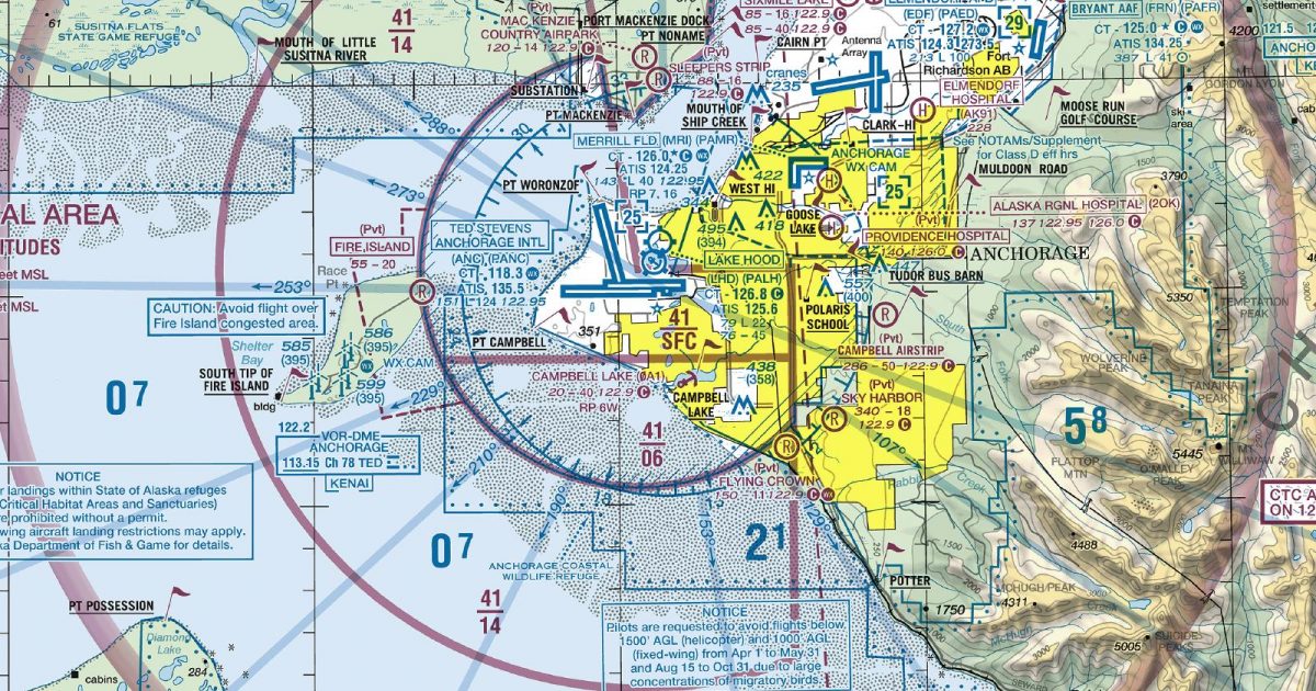
Official FAA digital chart — free GeoTIFF and PDF download
| Format | What you get | Size | |
|---|---|---|---|
| GeoTIFF | Georeferenced raster at 300 dpi, with world file and FGDC metadata | 48.1 MB | Download |
| Print-ready chart, no georeferencing | 95.9 MB | Download |
Not for navigation. For flight simulation and reference use only. Check the effective dates above, and obtain official charts from the FAA for real-world flight.

These are big files. This chart alone is 95.9 MB. Guest downloads are rate limited; PRO members get full-speed, unthrottled downloads across every chart and all 24,000+ add-ons in the library.
Go PROCook Inlet forms the spine of this Anchorage-centred sheet, with Southcentral Alaska’s settled lowlands compressed between water and mountain country. Coverage reaches north across the Susitna and Matanuska valleys, south over the upper Kenai Peninsula and lower Cook Inlet, and east into the Chugach Mountains and the northern reaches of Prince William Sound. To the west, it includes rugged volcanic terrain and the approaches to the Alaska Range.
The footprint brings together markedly different landscapes in a compact area. Broad tidal waterways and branching river flats contrast with steep ridges, glacier-cut valleys and extensive high ground. The Anchorage basin provides the sheet’s urban focus, while development thins quickly beyond it into large tracts of mountain, wetland and coastal terrain. Cook Inlet is a strong visual axis through much of the coverage; elsewhere, the Matanuska and Susitna corridors divide mountain groups and connect the central lowlands with the sheet’s northern and eastern margins.
| ID | Airport | City | Elev | Rwys | Longest |
|---|---|---|---|---|---|
| PANC ANC | Ted Stevens Anchorage Intl | ANCHORAGE, AK | 151 ft | 3 | 12,400 ft |
| PAEN ENA | Kenai Muni | KENAI, AK | 99 ft | 5 | 7,855 ft |
| PAAQ PAQ | Warren "bud" Woods Palmer Muni | PALMER, AK | 248 ft | 4 | 6,006 ft |
| PALH LHD | Lake Hood | ANCHORAGE, AK | 79 ft | 4 | 4,541 ft |
| PABV BCV | Birchwood | BIRCHWOOD, AK | 83 ft | 2 | 4,012 ft |
| PAMR MRI | Merrill Fld | ANCHORAGE, AK | 143 ft | 3 | 4,000 ft |
| PAWS IYS | Wasilla | WASILLA, AK | 353 ft | 2 | 3,700 ft |
| Z40 | Goose Bay | GOOSE BAY, AK | 78 ft | 1 | 3,000 ft |
| PAGQ BGQ | Big Lake | BIG LAKE, AK | 162 ft | 1 | 2,450 ft |
| AQY | Girdwood | GIRDWOOD, AK | 164 ft | 1 | 2,095 ft |
| 5HO | Hope | HOPE, AK | 193 ft | 1 | 2,040 ft |
| AK1 | Butte Muni | PALMER, AK | 64 ft | 1 | 1,806 ft |
| PAWR IEM | Whittier | WHITTIER, AK | 39 ft | 1 | 1,480 ft |
| A13 | Bold | ANCHORAGE, AK | 900 ft | 1 | 1,000 ft |
14 public-use airports within this chart's coverage, ordered by runway length. A further 126 private and restricted landing facilities are not listed. Source: FAA NASR 28-day subscription.
Approach plates and airport diagrams for every airport in the states this sheet covers:
It spans 60.5°N to 61.7°N and 153.1°W to 147.7°W. Airports on the sheet fall within Alaska. The full list of public-use airports within its coverage is on this page.
Take the GeoTIFF if you are loading the chart into moving-map software or a flight planner — it is georeferenced, so the software can place it correctly on a map, and it ships with a world file and FGDC metadata at 300 dpi (48.1 MB). Take the PDF to print it or read it on a second screen (95.9 MB); it is the same chart without georeferencing.
This is the FAA edition effective 3 September 2026, which is superseded on 29 October 2026. Visual charts are reissued every 56 days and we publish each new edition on the day it takes effect. It is for flight simulation and reference only — not for real-world navigation.
Yes, with no account required. FAA charts are United States Government works and are not subject to copyright protection in the US under 17 U.S.C. § 105. Guest downloads are speed-capped, so a sheet this size takes a while; PRO members download at full line speed and can take the whole family as one archive.

FAA public-domain products, mirrored unmodified. Fly Away Simulation is not affiliated with or endorsed by the FAA. Chart licensing and terms.

