Page 10
Searches the whole library — filter by sim & category on the results page
NZQN, Queenstown, New Zealand, gains a precise improved ILS, and parking areas are altered significantly to accommodate larger aircraft, while four NZQN-named files are included, credited to John B…
 New Zealand
Gustavo Luna models v1.5 for Boa Vista International Airport in Brazil, identified by the SBBV registration, and distributes the work as freeware linked to the SBBV - Boa Vista folder, replacing an…
 Brazil
By Chris Carel, this Caribbean seaplane compilation covers Grand Cayman, Jamaica, Mexico, Central America, Curacao, Bonaire and La Orchila, and requires CSPTF.ZIP with Florida Operations installed.…
 Global (World)
The EGPF designation near Glasgow UK receives a modest expansion around Glasgow Airport, extending runway 05/23 by 500 feet and adding a rapid exit taxiway from the 05 end, while runway 10/28 is cl…
 United Kingdom
Jim Cook refines KLSV by expanding parking with Military_Cargo and Military_Combat spots to accommodate multiple aircraft, adding a fire station area and service vehicles to improve emergency readi…
 United States of America
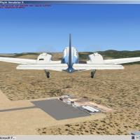
Version I of Corse Island project covers 104 of 143 communities on the island and counts seven airports, with mountainous terrain rendered in faithful detail. The presentation reflects Corsican geo…
 France
NFFN in Fiji receives an ADE-driven upgrade with crosswind runways active when using the CW_RS configuration. Four BGLs exist—NFFN_ADE_RS.BGL, NFFN_ADE_CW_RS.BGL, NFFN_ADE_CVX.bgl, and NFFN_ADE_OBJ…
 Fiji
Fiji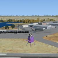
In Yellowknife, the airport carries IATA YZF and ICAO CYZF, sits in the Northwest Territories as part of the National Airports System, and the regional government operates it; it hosts regular pass…
 Canada
By Toni Agramont, Caribbe Nord coverage spans 57 islands and cays in the Virgin Islands and Leeward Islands, with 18 airports reconstructed and resized to reflect the terrain’s relief. Montserrat’s…
Global (World)Art Poole presents edits to Florida airports, including KTPA, KMCO, KORL, KSFB, KSRQ, KEYW, KVRB, KJAX, KSGJ, KEVB, KDAB and X60, relocating aprons, taxiways and boundary fences to resolve conflict…
United States of America
By Gustavo Luna, this Porto Velho Int'l Airport addon recreates the real layout with accurately placed taxiway signs, runway markings, and apron areas, while handcrafted buildings convey architectu…
Brazil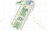
Newark Liberty International in New Jersey is modeled after Beijing, presenting three facilities: A for domestic, B for international, and C dedicated to Continental Airlines operations. C hosts Co…
United States of America
FTXDes maps the entire Albanian region at 2m/pixel resolution, spanning 28,748 square kilometers, with Tirana and major cities mapped, and employs watermasking and blendmasking to increase landscap…
 Albania
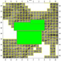
France-wide terrain mesh reaches version three, providing coverage at 38-meter resolution across France. It replaces earlier releases 1 and 2 and fixes issues, with creation by Raimondo Taburet in …
France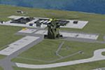
Two helipads appear at Copenhagen’s EKCH, with Runway 22R handling takeoffs and 22L hosting landings as 12/30 remains closed, following official EKCH guidance. The project uses the EKCH kastrup.bgl…
 Denmark
By MCDesigns, a new library of native objects accompanies forward operations in Iraq, including a reworked ADE file and landclass with new roads and animated traffic; areas center on the FOB at Hab…
 Iraq
Iraq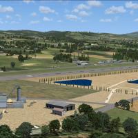
Alf Denham compiles Volume 3, upgrading four UK airfields: Lashenden (EGKH), North Weald (EGSX), Sherburn-in-Elmett (EGCJ), and Shobdon (EGBS). It relies on Google Earth and Pooleys UK Flight Guide…
United Kingdom
In Kermanshah, Iran, the project adds airport vehicles and stairs, chopper trailers, Acuair navaids, and static hangars. A new taxiway and runway, plus a water tower and beacon towers, rounds out t…
 Iran (Islamic Republic of)
SBNT designates Natal's international airport in Brazil and ships as version 1.6 by Gustavo Luna. A folder named SBNT - Natal resides in the ADDON directory, and users freely distribute it in its o…
Brazil
Ray Smith crafts a thorough overhaul of Perth International Airport in Western Australia, featuring two BGL configurations for runway use: YPPH_ADE_CW_RS.BGL with crosswind 6/24 and YPPH_ADE_RS.BGL…
 Australia