Terminal Procedures

KCVS — Cannon AFB

CLOVIS, NM · 14 FAA charts · cycle 6 Aug 2026

FAA CVSElevation 4,295 ft2 runwaysLongest 10,003 ftToweredFuel Jet A, A++Volume SW-1Not for navigation
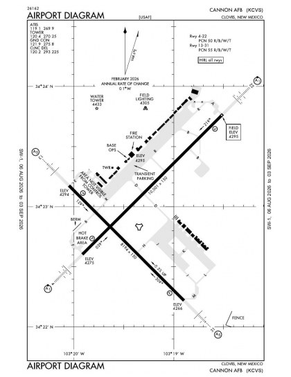
KCVS airport diagram — runways, taxiways and ramp layout
KCVS airport diagram The official FAA airport diagram — runways, taxiways, ramp layout and hold-short positions. Download PDF

12 published instrument approaches: 4 ILS approaches, 4 RNAV (GPS), serving 4 runway ends.

All 14 KCVS charts in one download Every approach, departure, arrival and minimums page for this airport, sorted into folders, as a single ZIP. Taken one at a time on the free tier, 14 charts is roughly 1 min of downloading — they queue one behind another.
PRO members only

Instrument approach procedures

ChartAmendment
ILS OR LOC RWY 04 chart previewILS OR LOC RWY 04PDF
ILS OR LOC RWY 13 chart previewILS OR LOC RWY 13PDF
ILS OR LOC RWY 22 chart previewILS OR LOC RWY 22PDF
ILS OR LOC RWY 31 chart previewILS OR LOC RWY 31PDF
RNAV (GPS) RWY 04 chart previewRNAV (GPS) RWY 04PDF
RNAV (GPS) RWY 13 chart previewRNAV (GPS) RWY 13PDF
RNAV (GPS) RWY 22 chart previewRNAV (GPS) RWY 22PDF
RNAV (GPS) RWY 31 chart previewRNAV (GPS) RWY 31PDF
TACAN RWY 04 chart previewTACAN RWY 04PDF
TACAN RWY 13 chart previewTACAN RWY 13PDF
TACAN RWY 22 chart previewTACAN RWY 22PDF
TACAN RWY 31 chart previewTACAN RWY 31PDF

Takeoff and alternate minimums

ChartAmendment
TAKEOFF MINIMUMS chart previewTAKEOFF MINIMUMSPDF

Minimums pages cover a whole volume, so the same document is shared by every airport in it.

KCVS airport information

Control tower
Yes
Attendance
Continuous
ARTCC
Albuquerque Center
Flight service
Albuquerque
NOTAM facility
CVS (NOTAM-D available)
Magnetic variation
7E
Beacon
White-green (lighted land airport), sunset to sunrise
Fuel
Jet A, A++
Airframe service
Major
Powerplant service
Major
Activated
November 1938
Ownership
Privately owned
Sectional
Albuquerque

From the FAA NASR 28-day subscription, cycle 6 Aug 2026.

KCVS radio frequencies

ServiceFrequencyCall sign
Tower120.4Cannon
Ground121.9Cannon
Clearance delivery120.2Cannon
ATIS119.1Cannon
Approach118.425Cannon
Emergency121.5Cannon

Civil VHF frequencies from the FAA NASR 28-day subscription. Discrete sector and military frequencies are not listed.

Runways

10,003 × 150 ft04228,196 × 150 ft1331N2,000 ft
Runway layout at KCVS, drawn to scale from FAA published runway-end coordinates and true alignments. Runways served by an ILS are highlighted.
RunwayLengthWidth SurfaceLighting
04/2210,003 ft150 ftConcreteHigh intensity
  04 45°TLOC/GS · PAPI (4-box) 2.5° · ALSF-1 approach lighting
  22 225°TLOC/GS · PAPI (4-box) 3° · ALSF-1 approach lighting
13/318,196 ft150 ftPorous asphaltHigh intensity
  13 135°TLOC/GS · PAPI (4-box) 3° · SSALR approach lighting
  31 315°TLOC/GS · PAPI (4-box) 3° · SSALR approach lighting

Runway and approach-aid data from the FAA NASR 28-day subscription.

Where KCVS is

Latitude, longitude34.3827750, -103.3221510
Elevation4,295 ft
From Clovis5 nm W

Paste the coordinates into a simulator’s world map to drop straight onto the field.

FAA remarks for KCVS

  • ABN UNSVC UFN.
  • VFR JET RECTANGULAR 5800 FT, TRAN JET OVERHEAD 5800 FT.
  • SHOULDER PAVEMENT DISTRESSED ALG BOTH SIDES ENTR LEN.
  • 20 FT IRRIGATION EQPT LCTD 2000 FT FM BOTH RWY ENDS. PSBL HYDROPLANING MID ASPH PORTION. PAVED SHOULDERS NA; 1-5 IN VERT EDGE ALG BOTH SIDES ENTIRE LEN.
  • 1400 FT NSTD LEN.
  • 1482 FT NSTD LEN.
  • 15 FT VEH ON ROAD 1200 FT FM RWY END. 1ST 1200 FT SFC ROUGH CONC.
  • 1ST 1200 FT BOTH ENDS CONC; MID 5800 FT ASPH CONC.
  • CTN: BIRD HAZ; SEWAGE LAGOON & LAKE 1/2 NM SE OF RWY 22.
  • DEP RSTD TO 5300 FT TIL DER.
  • SVC: GATED THR LGT ON RWY 04/22.
  • CTN: CLOVIS RGNL 13 NM NE; PORTALES MUNI 14 NM SSW.
  • CTN: BASH PHASE II IN EFCT 1 SEP-31 JAN; BASH PHASE 1 IN EFCT ALL OTR TIMES OF THE YEAR.
  • SEE FLIP AP/1 SUPPLEMENTARY ARPT RMK.
  • FUEL: J8.
  • FLUID: SP PRESAIR LPOX LOX.
  • SVC: TRANS ALERT: 1400-0600Z++ MON-FRI; 1300-2100Z++ SAT-SUN.
  • RSTD: 24 HR - 15 DAY PPR - D681-2801/C575-784-2801; ACFT ADHERE +/-30 MIN OR PPR INVALID.
  • MISC: TSNT WX BRIEFING AFT HR - 25 OWS DAVIS-MONTHAN AFB D228-6598/6599/6588, C520-228-6598/6599.
  • MISC: WX OBS SENT BY AN/FMQ19; AUGMENTED BY HUMAN OBS DURG SVR WX & EQUIP OUTAGE; OBS SITE LTD 240-020 DEG DUE TO BLDG; NGT OBS LTD DUE HI INTS RAMP LGT.
  • MISC: FIRE FIGHTING CPBLS LTD TO CAT 8-10 ACFT; VERIFY CPBLTY DURG PPR.
  • AD OFFL BUS ONLY FIRST FRI OF MONTH.
  • ALL HLDG APRON TAXI-LINES RSTD TO WHEELBASE MORE THAN 14 FT.
  • CTN: NVD OPS MAY BE CONDUCTED INVOF OF AIRFIELD BTN SS - SR.
  • CSTMS/AG/IMG: CUSTOMS SVC UNAVBL.
  • MISC: DV 0-6 & ABOVE OR CIV EQUIVALENT & ROTATORS - AIRFIELD MGMT PTD 372.2 & COMD POST UHF WHEN 100 NM OUT WITH ETA & REQS.
  • RSTD: TWY B RSTD TO C130 147000 LBS OR LESS.
  • CTN: TWY EDGE LGT 15 FT FM MRKD, STRESSED PAVEMENT ON TWY D AT INT OF TWY R.
  • CTN: WINGTIP CLNC FOR C130 ACFT IN PRKG ROW DELTA-INDIA 24 FT; ROW LIMA-PAPA 15 FT.
  • CTN: LOADED ACFT PRKD IN PROXIMITY OF RWY 31 APCH END.
  • SERVICE-OIL: OIL SVC UNAVBL FOR MIL-7808 OIL.
  • MISC: TSNT CLASSIFIED STORAGE UNAVBL.
  • JASU: (A/M32A-86).
  • SERVICE-OIL: JOAP
  • WX OPS H24; PSBL SDBY HR WKENDS BASED ON LCL FLYING.
  • CTN: UAS ACT WI 6 NM 9000 FT & BLW; WI CLASS D ASP & BTN CLASS D ASP & R5104.
  • CTN: ALL SIGNS FADED; ALL MARKINGS FADED & CHIPPED; SHOULDER MARKINGS NOT ACCURATELY PAINTED ON COMMANDO RAMP BTN HANGARS & TAXILANE DELTA.
  • ALL ARR/DEP MUST BE ABLE TO PERFORM 180 DEG TURN ON RWYS.

Published verbatim from the FAA NASR subscription. Abbreviations are the FAA's own.

Approach coverage across both runways

Cannon AFB has instrument procedures serving all four runway ends. The equal mix of ILS, localiser and RNAV (GPS) approaches provides both ground-based and satellite-based coverage across the field rather than concentrating procedures on a single alignment. With one runway exceeding 10,000 ft and the other still measuring 8,196 ft, neither alignment is represented by a short secondary strip.

Coverage beyond Cannon AFB

Clovis Regional has the broadest nearby procedure set, though its eight charts remain notably fewer than Cannon’s 14. Portales Municipal, Tucumcari Municipal, Muleshoe Municipal and Littlefield Taylor Brown Municipal have much thinner chart coverage. The Albuquerque Sectional adds the wider visual-navigation context that the airport diagram and terminal procedures do not provide.

Airports near KCVS

IDAirportCity DistanceCharts
KCVNClovis RgnlCLOVIS, NM12 nm E8
KPRZPortales MuniPORTALES, NM15 nm S3
2T1Muleshoe MuniMULESHOE, TX36 nm E1
KTCCTucumcari MuniTUCUMCARI, NM50 nm N5
KLIULittlefield Taylor Brown MuniLITTLEFIELD, TX54 nm SE2
KHRXHereford MuniHEREFORD, TX57 nm NE4

VFR charts covering KCVS

Common questions about KCVS

What charts are available for KCVS?

14 current FAA charts for Cannon AFB, including 12 instrument approachs, 1 airport diagram. All are free to download as PDFs from this page, from the 6 August 2026 cycle.

What are the radio frequencies for KCVS?

Tower 120.4; Ground 121.9; ATIS 119.1; Clearance delivery 120.2. Full civil VHF list, with sector notes, is in the frequencies table on this page — from the FAA NASR subscription.

How long is the runway at KCVS?

Cannon AFB has 2 runways. The longest is 04/22 at 10,003 ft by 150 ft, concrete. Full runway dimensions, lighting and approach aids are listed on this page.

Does KCVS have an ILS approach?

Yes — 4 ILS procedures are published. In total KCVS has 12 published instrument approaches, of which 4 are RNAV (GPS).

Where can I download the KCVS airport diagram?

The official FAA airport diagram for Cannon AFB is free to download at the top of this page. It shows runways, taxiways, ramp layout and hold-short positions, and is reissued every 28 days.

Is KCVS a towered airport?

Yes. Cannon AFB has an operating control tower, within Albuquerque Center's airspace. Tower, ground and clearance frequencies are listed on this page.

Are these KCVS charts current?

They are from the FAA cycle effective 6 August 2026, which is superseded on 3 September 2026. We publish each new cycle on its effective date. They are for flight simulation and reference only — not for real-world navigation.

Wider chart sets

Bulk archives are a PRO benefit. Individual charts are free for everyone, always.

Flying into KCVS? PRO members take all 14 charts as one ZIP instead of 14 separate downloads, at full line speed with no cap — plus every chart family archive and all 24,000+ add-ons in the library.

Go PRO

Not for navigation. For flight simulation and reference use only. Procedures are superseded on a 28-day cycle — obtain current official charts from the FAA for real-world flight.

FAA public-domain products, mirrored unmodified. Fly Away Simulation is not affiliated with or endorsed by the FAA. Chart licensing and terms.