Terminal Procedures

KLTS — Altus AFB

ALTUS, OK · 23 FAA charts · cycle 6 Aug 2026

FAA LTSElevation 1,381 ft3 runwaysLongest 13,440 ftToweredVolume SC-1Not for navigation
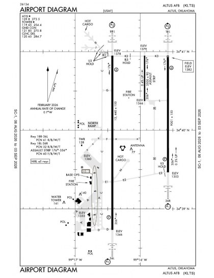
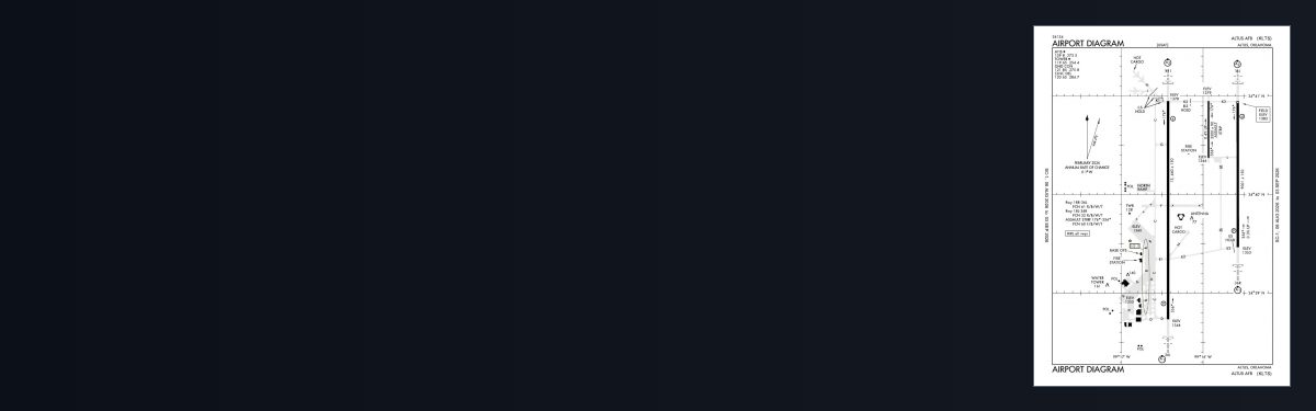
KLTS airport diagram — runways, taxiways and ramp layout
KLTS airport diagram The official FAA airport diagram — runways, taxiways, ramp layout and hold-short positions. Download PDF

18 published instrument approaches: 6 ILS approaches, 12 RNAV (GPS), 2 VOR, serving 4 runway ends.

All 23 KLTS charts in one download Every approach, departure, arrival and minimums page for this airport, sorted into folders, as a single ZIP. Taken one at a time on the free tier, 23 charts is roughly 2 min of downloading — they queue one behind another.
PRO members only

Instrument approach procedures

ChartAmendment
ILS OR LOC RWY 18L chart previewILS OR LOC RWY 18LPDF
ILS OR LOC RWY 36R chart previewILS OR LOC RWY 36RPDF
ILS OR RNAV (GPS) Y RWY 18R chart previewILS OR RNAV (GPS) Y RWY 18RPDF
ILS OR RNAV (GPS) Y RWY 36L chart previewILS OR RNAV (GPS) Y RWY 36LPDF
ILS Z OR LOC RWY 18R chart previewILS Z OR LOC RWY 18RPDF
ILS Z OR LOC RWY 36L chart previewILS Z OR LOC RWY 36LPDF
RNAV (GPS) Z RWY 18L chart previewRNAV (GPS) Z RWY 18LPDF
RNAV (GPS) Z RWY 18R chart previewRNAV (GPS) Z RWY 18RPDF
RNAV (GPS) Z RWY 36L chart previewRNAV (GPS) Z RWY 36LPDF
RNAV (GPS) Z RWY 36R chart previewRNAV (GPS) Z RWY 36RPDF
RNAV (GPS)-A chart previewRNAV (GPS)-APDF
RNAV (GPS)-B chart previewRNAV (GPS)-BPDF
RNAV (RNP) X RWY 18R chart previewRNAV (RNP) X RWY 18RPDF
RNAV (RNP) X RWY 36L chart previewRNAV (RNP) X RWY 36LPDF
RNAV (RNP) Y RWY 18L chart previewRNAV (RNP) Y RWY 18LPDF
RNAV (RNP) Y RWY 36R chart previewRNAV (RNP) Y RWY 36RPDF
VOR OR TACAN RWY 18R chart previewVOR OR TACAN RWY 18RPDF
VOR OR TACAN RWY 36L chart previewVOR OR TACAN RWY 36LPDF

Departure procedures

ChartAmendment
OKKIE THREE (RNAV) chart previewOKKIE THREE (RNAV)PDF
ROCKN THREE (RNAV) chart previewROCKN THREE (RNAV)PDF

Takeoff and alternate minimums

ChartAmendment
TAKEOFF MINIMUMS chart previewTAKEOFF MINIMUMSPDF

Minimums pages cover a whole volume, so the same document is shared by every airport in it.

Hot spots

ChartAmendment
HOT SPOT chart previewHOT SPOTPDF

KLTS airport information

Control tower
Yes
Attendance
All mon-fri 1500-0830z++
ARTCC
Fort Worth Center
Flight service
Mc Alester
NOTAM facility
LTS (NOTAM-D available)
Magnetic variation
5E
Beacon
Split-white-green (military airport), sunset to sunrise
Wind indicator
Yes
Airframe service
Major
Powerplant service
Major
Bottled oxygen
Low
Customs
Landing rights airport
Activated
July 1943
Airport area
2,489 acres
Ownership
Privately owned
Sectional
Dallas-Ft Worth

From the FAA NASR 28-day subscription, cycle 6 Aug 2026.

KLTS radio frequencies

ServiceFrequencyCall sign
Tower119.65Altus
Ground121.85Altus
Clearance delivery120.65Altus
ATIS109.8Altus
Approach125.1Altus
Emergency121.5Altus

Civil VHF frequencies from the FAA NASR 28-day subscription. Discrete sector and military frequencies are not listed.

Runways

13,440 × 150 ft18R36L9,001 × 150 ft18L36R3,500 × 90 ft176356N2,000 ft
Runway layout at KLTS, drawn to scale from FAA published runway-end coordinates and true alignments. Runways served by an ILS are highlighted.
RunwayLengthWidth SurfaceLighting
18R/36L13,440 ft150 ftConcrete GoodHigh intensity
  18R 180°TILS · PAPI (4-box) 3° · SALSF
  36L 360°TILS · PAPI (4-box) 3° · ALSF-1 approach lighting · right-hand circuit
18L/36R9,001 ft150 ftConcrete GoodHigh intensity
  18L 180°TLOC/GS · PAPI (4-box) 3° · SALSF
  36R 360°TLOC/GS · PAPI (4-box) 3° · ALSF-1 approach lighting
176/3563,500 ft90 ftConcrete GoodHigh intensity

Runway and approach-aid data from the FAA NASR 28-day subscription.

Where KLTS is

Latitude, longitude34.6679750, -99.2677510
Elevation1,381 ft
From Altus3 nm E

Paste the coordinates into a simulator’s world map to drop straight onto the field.

FAA remarks for KLTS

  • TPA EAST OVHD RWY 18L/36R/176/356 3400 FT, WEST OVHD RWY 18R/36L 3400 FT, EAST RECTANGULAR 2900 FT WEST (97 AMW ACFT ONLY) RECTANGULAR 2900 FT, COPTER 1900 FT.
  • CLSD WKEND AND HOL. TRAN ACFT: 1530-0830Z++, CLSD WKEND AND HOL.
  • FIRST 1000 FT OF RWY 18L/36R IS CONC. MIDDLE 7001 FT OF RWY 18L/36R IS POROUS FRICTION SFC.
  • JASU: A/M32-86) (AM32A-95A) (MXU-4A-A)
  • SERVICE-FUEL: A++.
  • TRAN ALERT: SVC AVBL 1500-0001Z++ MON-FRI; CLSD SAT, SUN AND HOL. TRAN MAINT AND PARTS SUPPORT EXTRMY LTD.
  • MISC: TWR VIS OBST OF RWY 36L APCH END AND TWY C, SOUTH OF TWY E-1 INTXN.
  • RSTD: ALTUS ACFT TAKE PRIORITY OVER TRAN ACFT.
  • RSTD: DUE TO UNSKED AFLD CLOSINGS, AIRCREWS UTILIZING ALTUS AFB AS AN ALTN MUST ADVS THEIR DEP AM OPS OR LCL FSS TO INCL KLTSYXYX AS AN ADDRESSEE ON THE ORIG DD 1801 FLIGHT PLAN AND ON ANY CHG, DELAY, DEP AND CNL MSG.
  • FLUID: W SP PRESAIR LHOX LOX.
  • OIL: O-133-148-156 SOAP (24 HR PN).
  • CTN: HVY/JUMBO JET TRNG SFC TO 9000 FT WI 25 NMR.
  • RSTD: PPR RQR 48 HR PN RQR (TRNG OR OPERATIONAL). CTC AIRFIELD MANAGEMENT OPNS DSN 866-6200/6415, C580-481-6200/6415. PPR VALID +/-30 MIN PRIOR/AFTER ETA. EARLY/LATE ARRS/DEPTS MUST RE-COORDINATE WITH AIRFIELD MANAGEMENT OPS.
  • RSTD: ALL INBOUND PAX/CARGO ACFT CTC CMD POST (GERONIMO 349.4) NLT 30 MNS PRIOR TO LDG. ALL ACFT W/HAZARDOUS CARGO (INCLUDING MJU7 AND MJU10 FLARES) NTFY AIRFIELD MANAGMENT OPS (327.2) AND CMD POST NLT 30 MINS PRIOR TO LDG.
  • RSTD: MNM COMSEC AIDS AND OVERNIGHT STORAGE AVBL FOR TRANSIENT AIRCREWS ONLY.
  • RSTD: TRANSIENT AIRCREWS MUST CTC AM OPS FOR PAT WORK REQ. LMTD TO ONE APCH MON-FRI.
  • TRAN ALERT: TRANSIENT MAINTENANCE UNABLE TO PERFORM A MAGNETIC CHIP INDICATOR INSPECTION ON F16 AIRCRAFT WITH GE F110 ENGINES.
  • SVC-LGT: REDUCED PRI SFC OBSTN LGTS FOR RWY 18L/36R DURG NVD OPS. RWY 18R, 18L, 36R, & 36L SFL O/S UFN.
  • RSTD: RWY 176/356 FOR ASSAULT STRIP TRNG ONLY. TRANS ACFT REQ ASSAULT STRIP USE CTC CURRENT OPS FOR SCHED/APVL DSN 866-6544.
  • SEE FLIP AP/1 SUPPLEMENTARY ARPT INFO.
  • CTN: NO TWY EDGE LGT TWY D SOUTH SIDE TO TWY B TO RWY 36L; RETRO-REFLECTIVE MARK IN PLACE.
  • SVC LGT: RWY 18R, 18L, 36R AND 36L SFL OTS.
  • CTN: EXER EXTREME CAUTION FOR ACFT (1425 FT MSL) TAXIING 350 FT EAST OF DEP END ASSAULT RWY 176.
  • CTN: NON-STD MRK: C17 STAR TURN MARKINGS LCTD ON THE N RAMP, TWY J, AND TWY L/M GND OPS AREA.
  • CTN: NVD TRNG APRX 1 HR AFTER SS TIL AFLD CLOSURE NIGHTLY DUR AFLD HR. IAW 97 OG NVD/WHITE-LIGHT OPS MOU ALL TRAN ACFT REQ PAT TRNG BTN 1 HR AFTER SS TIL AFLD CLOSURE MUST BE OPERATING UNDER LOA THAT INCLUDES NVD OPS. TO OBTAIN LOA, CTC CURRENT OPS DSN 866-6544. ALL TRANS ACFT WILL CTC AMOPS (327.2) OR CMD POST (GERONIMO 349.4) 30 MIN PRIOR TO ARR.
  • RWY 18L/36R MRKD WITH NON-REFLECTIVE 90 FT X 3500 FT ASSAULT LZ MRK. NSTD WING TIP CLNC TRNG LINE MRKGS LCTD AT TWY B & B2 INTXNS, TWY B & D INTXN, AND TWY A & C INTXN.
  • CTN: BASH PHASE II IN EFF 15 NOV THRU 28/29 FEB FOR MIGRATORY BIRDS. NO TKOF OR LDG WI 1 HR OF SR/SS, 97 OG/CC WAIVER AUTH. CTC TWR FOR CURRENT BIRD WATCH COND.

Published verbatim from the FAA NASR subscription. Abbreviations are the FAA's own.

Approach and runway coverage

Altus AFB’s 18 approach charts serve four runway ends, so instrument coverage is not confined to one alignment or direction. The mix of ILS, localiser, RNAV (GPS) and VOR procedures provides both ground-based and satellite-based options. Runway lengths form three distinct tiers: the 13,440-ft and 9,001-ft parallels provide substantially more usable distance than the separate 3,500-ft runway, giving the field markedly different runway-length profiles.

Surrounding chart context

None of the nearby listed airports has comparably broad procedure coverage: Hobart Regional has the largest nearby set at five charts, while Scott Field and Frederick Regional each have three. The Dallas–Ft Worth Sectional adds the wider visual-reference and airspace context that the airport diagram and terminal procedures do not provide.

Airports near KLTS

IDAirportCity DistanceCharts
KAXSAltus/Quartz Mountain RgnlALTUS, OK4 nm NW4
2K4Scott FldMANGUM, OK19 nm NW3
KHBRHobart RgnlHOBART, OK22 nm NE5
KFDRFrederick RgnlFREDERICK, OK24 nm SE3
F05Wilbarger CountyVERNON, TX27 nm S4
O35Hollis MuniHOLLIS, OK32 nm W4
KCSMInfinity One Oklahoma SpaceportBURNS FLAT, OK40 nm N8
KLAWLawton-Fort Sill RgnlLAWTON, OK42 nm E7

VFR charts covering KLTS

Common questions about KLTS

What charts are available for KLTS?

23 current FAA charts for Altus AFB, including 18 instrument approachs, 2 departure procedures, 1 airport diagram. All are free to download as PDFs from this page, from the 6 August 2026 cycle.

What are the radio frequencies for KLTS?

Tower 119.65; Ground 121.85; ATIS 109.8; Clearance delivery 120.65. Full civil VHF list, with sector notes, is in the frequencies table on this page — from the FAA NASR subscription.

How long is the runway at KLTS?

Altus AFB has 3 runways. The longest is 18R/36L at 13,440 ft by 150 ft, concrete. Full runway dimensions, lighting and approach aids are listed on this page.

Does KLTS have an ILS approach?

Yes — 6 ILS procedures are published. In total KLTS has 18 published instrument approaches, of which 12 are RNAV (GPS).

Where can I download the KLTS airport diagram?

The official FAA airport diagram for Altus AFB is free to download at the top of this page. It shows runways, taxiways, ramp layout and hold-short positions, and is reissued every 28 days.

Is KLTS a towered airport?

Yes. Altus AFB has an operating control tower, within Fort Worth Center's airspace. Tower, ground and clearance frequencies are listed on this page.

Are these KLTS charts current?

They are from the FAA cycle effective 6 August 2026, which is superseded on 3 September 2026. We publish each new cycle on its effective date. They are for flight simulation and reference only — not for real-world navigation.

Wider chart sets

Bulk archives are a PRO benefit. Individual charts are free for everyone, always.

Flying into KLTS? PRO members take all 23 charts as one ZIP instead of 23 separate downloads, at full line speed with no cap — plus every chart family archive and all 24,000+ add-ons in the library.

Go PRO

Not for navigation. For flight simulation and reference use only. Procedures are superseded on a 28-day cycle — obtain current official charts from the FAA for real-world flight.

FAA public-domain products, mirrored unmodified. Fly Away Simulation is not affiliated with or endorsed by the FAA. Chart licensing and terms.