Terminal Procedures

KNYL — Yuma MCAS/Yuma Intl

YUMA, AZ · 12 FAA charts · cycle 6 Aug 2026

FAA NYLElevation 213 ft4 runwaysLongest 13,300 ftToweredFuel 100, Jet A, Jet A+Volume SW-4Not for navigation
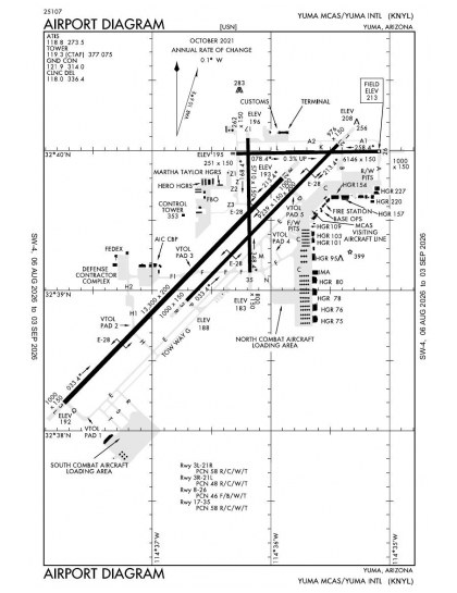
KNYL airport diagram — runways, taxiways and ramp layout
KNYL airport diagram The official FAA airport diagram — runways, taxiways, ramp layout and hold-short positions. Download PDF

7 published instrument approaches: 1 ILS approach, 2 RNAV (GPS), serving 2 runway ends.

All 12 KNYL charts in one download Every approach, departure, arrival and minimums page for this airport, sorted into folders, as a single ZIP. Taken one at a time on the free tier, 12 charts is roughly 1 min of downloading — they queue one behind another.
PRO members only

Instrument approach procedures

ChartAmendment
HI-TACAN Z RWY 03L chart previewHI-TACAN Z RWY 03LPDF
HI-TACAN Z RWY 21R chart previewHI-TACAN Z RWY 21RPDF
ILS OR LOC RWY 21R chart previewILS OR LOC RWY 21RPDF
RNAV (GPS) RWY 03L chart previewRNAV (GPS) RWY 03LPDF
RNAV (GPS) RWY 21R chart previewRNAV (GPS) RWY 21RPDF
TACAN Y RWY 03L chart previewTACAN Y RWY 03LPDF
TACAN Y RWY 21R chart previewTACAN Y RWY 21RPDF

Departure procedures

ChartAmendment
YUMA ONE chart previewYUMA ONEPDF

Obstacle departure procedures

ChartAmendment
BARD ONE (OBSTACLE) chart previewBARD ONE (OBSTACLE)PDF

Takeoff and alternate minimums

ChartAmendment
TAKEOFF MINIMUMS chart previewTAKEOFF MINIMUMSPDF
RADAR MINIMUMS chart previewRADAR MINIMUMSPDF

Minimums pages cover a whole volume, so the same document is shared by every airport in it.

KNYL airport information

Control tower
Yes
ARTCC
Los Angeles Center
Flight service
Prescott
NOTAM facility
NYL (NOTAM-D available)
Magnetic variation
13E
Beacon
White-green (lighted land airport), sunset to sunrise
Wind indicator
Lighted
ARFF index
Index A
Fuel
100, Jet A, Jet A+
Airframe service
Minor
Powerplant service
Minor
Bottled oxygen
High/low
Parking
Tie-downs
Customs
Landing rights airport
Activated
April 1940
Airport area
3,100 acres
Ownership
Privately owned
Sectional
Phoenix
Last FAA inspection
2026-05-28

From the FAA NASR 28-day subscription, cycle 6 Aug 2026.

KNYL radio frequencies

ServiceFrequencyCall sign
CTAF119.3
UNICOM122.95
Ground121.9Yuma
ATIS118.8Yuma
Emergency121.5Yuma

Civil VHF frequencies from the FAA NASR 28-day subscription. Discrete sector and military frequencies are not listed.

Runways

13,300 × 200 ft03L21R9,240 × 150 ft03R21L6,146 × 150 ft08265,710 × 150 ft1735N3,000 ft
Runway layout at KNYL, drawn to scale from FAA published runway-end coordinates and true alignments. Runways served by an ILS are highlighted.
RunwayLengthWidth SurfaceLighting
03L/21R13,300 ft200 ftConcrete GoodHigh intensity
  03L 44°TPAPI (4-box) 3° · right-hand circuit
  21R 224°TILS · PAPI (4-box) 3° · MALSR approach lighting
03R/21L9,240 ft150 ftAsphalt over concrete GoodHigh intensity
  03R 44°TPAPI (4-box) 3° · right-hand circuit
  21L 224°TPAPI (4-box) 3°
08/266,146 ft150 ftAsphalt GoodHigh intensity
  08 89°Tright-hand circuit
17/355,710 ft150 ftAsphalt over concrete GoodHigh intensity
  17 179°TPAPI (4-box) 3° · right-hand circuit

Runway and approach-aid data from the FAA NASR 28-day subscription.

Where KNYL is

Latitude, longitude32.6565740, -114.6059870
Elevation213 ft
From Yuma3 nm S

Paste the coordinates into a simulator’s world map to drop straight onto the field.

FAA remarks for KNYL

  • ESTABLISHED PRIOR TO 5/15/59.
  • WHEN ATCT CLSD ACTVT HIRL RWY 08/26 & 17/35; TWYS A, A1, A2, B, C, L, Z - CTAF.
  • TPA RWY 03L/R RIGHT TRAFFIC 1700 FT; RWY 21L/R LEFT TRAFFIC 1700FT. INITIAL ALT FOR OVERHEAD 4000 FT 6NM. INITIAL ALT FOR STRAIGHT-IN 3000 FT 6NM. COPTER - 700 FT FOR ANY RWY.
  • MIL AVN OPS NA 1430-1500Z DLY. VAL/TRANS SVC ABVL MON-FRI 1500-0600Z, CLSD SAT-SUN, HOL.
  • GLADYS BROWN
  • 928-726-5882. USMC - 928-269-2326.
  • INSTR FREQ 123.30.
  • 18 FT WINDSOCK 130 FT L OF RWY END.
  • 17 FT WINDSOCK 140 FT L 100 FT FM END.
  • 14 FT WINDSOCK 110 FT L 90 FT FM RWY END .
  • CTN: TFC PAT RWY 03L/R & 21L/R OVERLAP TFC PAT RWY 08/26 & 17/35.
  • 976 FT STWY RWY 03R; 1000 FT STWY RWY 21L; 1000 FT STWY RWY 03L; 1000 FT STWY RWY 21R; 1000 FT STWY RWY 08; 251 FT STWY RWY 26; 800 FT STWY RWY 17; 262 FT STWY RWY 35.
  • GEN AVN & ACR VFR DEP FLY RWY HDG MNTN 1200 FT UNTIL OUTSIDE ATA UNLESS OTRW APVD BY TWR.
  • MIL JET OPS FM 4000-3000 FT MSL DESCENDING TO 1700 FT MSL WI 6 NM SW STRAIGHT-IN RWY 03L & 03R & WI 6 NM NE STRAIGHT-IN RWY 21R & 21L.
  • CTN: JOINT USE CIVIL/MIL ARPT; GEN AVN & ACR OPR VFR ENTER ATA AT 1200 FT WHEN ASGN RWY 08/26 OR 17/35.
  • HEL ENTER ARPT TFC AREA AT TFC PAT ALT 1200 FT THEN DESCEND TO 700 FT PRIOR TO ALL RWYS.
  • PART 77 OBSTRNS-RADAR TWR E, POLES NEAR RWY 17.
  • JASU: 1(NC-10) 1(NCPP-105)
  • FLUID: LOX LHNIT LPOX
  • FUEL - F-24(MIL)-AVBL O/R FOR SHIPBOUND ACFT. F-24(MIL). A, A+ (FBO: 928-247-9571; 131.225, AVBL MON-FRI 1300-0400Z, SAT-SUN 1300-0100Z, OT 1 HR MIN PN). (NC-100).
  • OIL - O-156
  • RSTD: FLT CLNC MANNED DURG MIL OPS HR - D269-2326/2323/2077, C928-269-2326/2323/2077. TSNT 24 HR PPR - D269-2445/2760, C928-269-2445/2760. AV8B VSTOL TRNG TO RWY 03/21 MAY HAVE PRIORITY MON-FRI OVER MIL PRAC APCH.
  • MIL USE: ILS RADAR; SEE TERMINAL FLIP FOR RADAR MINIMA.
  • 24 HR PPR FOR ALL TSNT FR VAL C928-269-2445, D269-2445. 24 HR PPR ALL TSNT UTILIZING MIL RAMP; D951-2445/2760, C928-269-2445/2760. MIL ACFT REQ TO RWY 03/21 MAY HAVE PRIORITY MON-SAT OVER PRACTICE APCHS.
  • MILITARY USE: VHF/DF
  • MISC: AMBULANCE OPS BTN 0500-1300Z NEEDING GND ACCESS - CIVIL ARPT AUTH C928-941-2396 OR 376-5868.
  • US CUSTOMS PORT OF ENTRY - 928-344-9572 OR 928- 314-1295.
  • CIVIL ARPT OPS - 928-726-5882 EXTN 2161 OR 928-941-2396
  • TWY A2 PCN 33/F/B/W/T, TWY K PCN 30/G/B/W/T, TWY L PCN 33/F/B/W/T, TWY Z PCN 33/F/B/W/T
  • ROTARY WING ACFT RECOVERY NA TO VTOL PAD-4.
  • CTN: AVOID OVFT MEXICAN BORDER 7 NM W, JET TRNG OPS INVOF. HIGH VOLUME LCL AREA OPS ON UHF; VHF OPS EXER CTN & STRICT COMPLIANCE TO ATC INSTR.
  • AVOID OVFT OF MCAS YUMA INFRASTRUCTURE E OF MAIN APRON.
  • OPS HR APPLIES TO MIL INCLG YUMA INTL & FBO; AFT HR TWO WEEK PPR IN WRITING - 928-269-3327/D269-3327.
  • FOD RSTRN: HVY/WIDE BODY ARR/DEP RWY 03L/21R ONLY; MCAS YUMA S MAIN PRKG APN/VAL BACK TAX RWY 03L/21R THEN TWY D; YUMA INTL/MILLION AIR YUMA FBO DEF CONTRR CMPLX PRKG APN BACK TAX RWY 03L/21R THEN TWY H1 OR F1. OTR RWY OR TWY NA. HVY/WIDE BODY ENG RUNUPS ON RWY NA EXC USAF 1/2.
  • ARFF NA AFT OPS HR EXC SKED PART 121 ACR.
  • FOR CD CTC YUMA CERAP AT 928-269-9569.
  • F/W, R/W & F35 RAPID RFL HOT PIT AVBL DURG ATCT HR WITH 24 HR PPR - 928-247-9571 OR 131.225; 2 ACFT SIMUL OPS AVBL; ADZ ATC & PROCD TO S RAMP OFF TWY Z3.
  • MCAS BASE OPS - D269-7050/2077. MIL OPS 1430-0600Z DLY; CLSD HOL.

Published verbatim from the FAA NASR subscription. Abbreviations are the FAA's own.

Concentrated instrument coverage

Yuma’s four-runway layout contrasts with instrument approaches serving only two of its eight runway ends. The published set includes ILS, localiser and RNAV (GPS) procedures, concentrating instrument access on a small part of the available runway configuration. With the longest runway extending to 13,300 ft and another exceeding 9,000 ft, the layout provides two notably long strips alongside two shorter alignments. The airport diagram is particularly useful for distinguishing the four intersecting runway pairs.

Surrounding chart coverage

Among nearby fields, El Centro NAF has the closest breadth of procedure coverage. Laguna AAF and Imperial County have smaller but still substantial sets, while Brawley Municipal and Cliff Hatfield Memorial are much more thinly charted. The Los Angeles and Phoenix sectionals add wider VFR context beyond the terminal procedures.

Airports near KNYL

IDAirportCity DistanceCharts
KLGFLaguna AAF (Yuma Proving Ground)YUMA PROVING GROUND (YUMA), AZ16 nm NE5
KBWCBrawley MuniBRAWLEY, CA50 nm NW3
KIPLImperial CountyIMPERIAL, CA50 nm W5
KCLRCliff Hatfield MemlCALIPATRIA, CA54 nm NW2
KNJKEl Centro Naf (Vraciu Fld)EL CENTRO, CA55 nm W8
KBLHBlytheBLYTHE, CA58 nm N4

VFR charts covering KNYL

Common questions about KNYL

What charts are available for KNYL?

12 current FAA charts for Yuma MCAS/Yuma Intl, including 7 instrument approachs, 1 departure procedure, 1 airport diagram. All are free to download as PDFs from this page, from the 6 August 2026 cycle.

What are the radio frequencies for KNYL?

Ground 121.9; ATIS 118.8; CTAF 119.3; UNICOM 122.95. Full civil VHF list, with sector notes, is in the frequencies table on this page — from the FAA NASR subscription.

How long is the runway at KNYL?

Yuma MCAS/Yuma Intl has 4 runways. The longest is 03L/21R at 13,300 ft by 200 ft, concrete. Full runway dimensions, lighting and approach aids are listed on this page.

Does KNYL have an ILS approach?

Yes — 1 ILS procedure is published. In total KNYL has 7 published instrument approaches, of which 2 are RNAV (GPS).

Where can I download the KNYL airport diagram?

The official FAA airport diagram for Yuma MCAS/Yuma Intl is free to download at the top of this page. It shows runways, taxiways, ramp layout and hold-short positions, and is reissued every 28 days.

Is KNYL a towered airport?

Yes. Yuma MCAS/Yuma Intl has an operating control tower, within Los Angeles Center's airspace. Tower, ground and clearance frequencies are listed on this page.

How many runways does KNYL have?

4, which is why the chart set is as large as it is — each runway end that supports an instrument approach needs its own plates. The runway diagram on this page shows the layout to scale.

Are these KNYL charts current?

They are from the FAA cycle effective 6 August 2026, which is superseded on 3 September 2026. We publish each new cycle on its effective date. They are for flight simulation and reference only — not for real-world navigation.

Wider chart sets

Bulk archives are a PRO benefit. Individual charts are free for everyone, always.

Flying into KNYL? PRO members take all 12 charts as one ZIP instead of 12 separate downloads, at full line speed with no cap — plus every chart family archive and all 24,000+ add-ons in the library.

Go PRO

Not for navigation. For flight simulation and reference use only. Procedures are superseded on a 28-day cycle — obtain current official charts from the FAA for real-world flight.

FAA public-domain products, mirrored unmodified. Fly Away Simulation is not affiliated with or endorsed by the FAA. Chart licensing and terms.