Page 45
Searches the whole library — filter by sim & category on the results page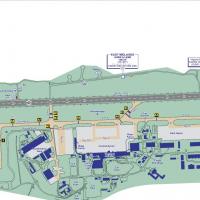
EGNX, a UK airfield, receives a complete re-work using ADE9x and default objects, corrected to satelite images and certified maps, by Chris Barrott. It is the first in a series of airport correctio…
 United Kingdom
Deenesh Suddoo authors a Mauritius airport with code FIMP. It notes a prior upload ssr_international.zip and includes a dedicated FIMP folder linked to the airport layout in Mauritius, with Deenesh…
 Mauritius
New Zealand's Ruapehu forms a 110 cu km andesitic massif with a summit Crater Lake vent and a surrounding 100 cu km ring plain. Subplinian eruptions occur between 22,600 and 10,000 years ago, and l…
 New Zealand
Southern Africa-focused component presents photorealistic backgrounds and buildings for Victoria Falls, Lambert's Bay Caravan Park on the West coast of South Africa, and Marromeu Airfield on the Za…
 Global (World)
Three airfields populate the island, including Palma de Mallorca and two additional sites: Es Pont d’Inca (Son Bonet) and Pollensa seaplane base. By Harry Patten, three bgl files go into the add-on…
 Spain
Spain
Roskilde Airport (EKRK) serves business travelers and operates as a customs point for international flights, anchoring a key node in Denmark's regional air network in the capital region, while majo…
 Denmark
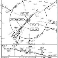
Cristobal Laje creates the SBCG scenario for Campo Grande International Airport in Mato Grosso do Sul, Brazil. It uses default objects drawn from libraries, with a radar fixed to the SBCG folder, a…
 Brazil
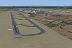
Frankfurt's airport adds a third runway, identified as 6/24, which measures 9240 feet in overall length. An image named fsx1.jpg accompanies the record, illustrating the modification and offering a…
 Germany
Version 1.1 of Formosa X RCTP Airport fixes background issues and renames runways to 05L-23R and 05R-23L in anticipation of the August 25, 2011 effective date. The patch requires Formosa X RCTP Air…
 Taiwan, Province of China
Two files, BR2_LFPG__2007_1_XO.BGL and BR3_LFPG_XO.BGL, govern LFPG's updated layout and apron lighting, by Xavier Ossedat, while three .fx files control warning beacons in the vicinity of runways.…
 France
Alexandre Vieira delivers a photoreal depiction of the SBSV Dois de Julho Airport area in Bahia, Brazil, using SbuilderX with Luis de Sá and based on aerial imagery, with the file name SBSV Salvado…
Brazil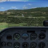
Version 2.0 covers Jundiai Airfield (SDJD) near Sao Paulo, Brazil, with altitude corrections, improved runway markings, and new parking positions and lights, Ren Scen earns credit. Brazilian locale…
Brazil
Version 2 of the Gibraltar project, created by Pips Perez, is built with SBuilderX at zoom level 18 and relies on srt2eur.zip and srt2eur2.zip. Coastline is adjusted at the southeast to keep the se…
 Gibraltar
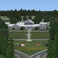
An addon for Whiting Field, North and South, adds ILS on KNDZ runway 32, six-strobe MALSR, and radial data to NSE VORTAC (112.3). The upgrade concentrates on navigation aids and runway data enhance…
 United States of America
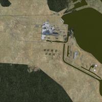
An expansive layout centers on the Chernobyl NPP as it appears from 1997 to 2005, with a custom built reactor building and extensive landclass textures for the surrounding area. NPP6 uses default o…
 Ukraine
Quality depiction centers on Catalina Island, identified by the KAVX code, delivering photorealistic rendering with a highly detailed airport and satellite imagery. Autogen stays off beyond the air…
United States of America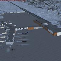
An FSDS-built terminal area updates the facility at the KDSM region, adding a dedicated Iowa Air National Guard 132nd Fighter Wing area and ensuring gates are accurately portrayed. Gates are number…
United States of America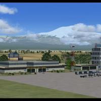
By Jacques Botha and Frits Beyer, this freeware design recreates HTKJ, the airport at Kilimanjaro in Tanzania, Africa, with custom hangars and buildings. Kilimanjaro_X.zip contains the HTKJ_Kiliman…
 Tanzania, United Republic of
MYGF serves Freeport, Bahamas, and stands as the region’s gateway after Nassau. The project, by Bahamasflyers and Shawn Penn, follows official specs to resemble Grand Bahama Intl Airport, emphasizi…
 Bahamas
A KAUS rebuild updates the Austin-Bergstrom airport with photo-real ground imagery, adds a parking garage and cargo buildings. Runways and aprons align to satellite imagery, and new approach lights…
United States of America