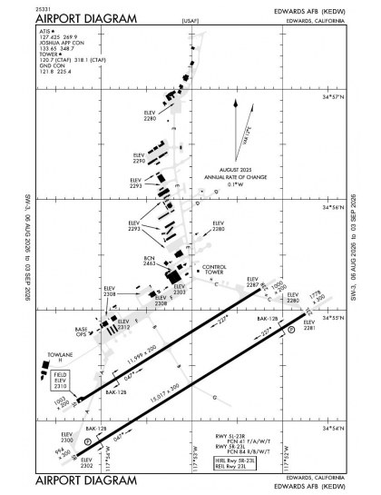
KEDW airport diagramThe official FAA airport diagram — runways,
taxiways, ramp layout and hold-short positions.Download PDF
8 published instrument approaches: 2 ILS approaches, 2 RNAV (GPS), 2 VOR, serving 2 runway ends.
All 12 KEDW charts in one downloadEvery approach, departure, arrival and minimums page
for this airport, sorted into folders, as a single ZIP. Taken one at a time on the free tier, 12 charts is roughly 1 min of downloading — they queue one behind another.
Minimums pages cover a whole volume, so the same
document is shared by every airport in it.
KEDW airport information
Control tower
Yes
Attendance
All mon-fri
ARTCC
Los Angeles Center
Flight service
Riverside
NOTAM facility
EDW (NOTAM-D available)
Magnetic variation
12E
Beacon
White-green (lighted land airport), sunset to sunrise
Wind indicator
Yes
Fuel
100LL avgas, JP-8
Bottled oxygen
Low
Customs
Landing rights airport
Ownership
Privately owned
Sectional
Los Angeles
From the FAA NASR 28-day subscription, cycle 6 Aug 2026.
KEDW radio frequencies
Service
Frequency
Call sign
CTAF
120.7
Ground
121.8
Edwards
ATIS
127.425
Edwards
Approach
133.65
Edwards
Emergency
121.5
Edwards
Civil VHF frequencies from the FAA NASR 28-day
subscription. Discrete sector and military frequencies are not listed.
Runways
Runway layout at KEDW, drawn to scale from FAA published runway-end coordinates and true alignments. Runways served by an ILS are highlighted.
Runway
Length
Width
Surface
Lighting
05R/23L
15,024 ft
300 ft
Concrete
High intensity
05R 58°T
PAPI (4-box) 3°
23L 238°T
LOC/GS · PAPI (4-box) 2.5°
05L/23R
12,000 ft
200 ft
Asphalt
07/25
8,000 ft
50 ft
Concrete
Runway and approach-aid data from the FAA NASR
28-day subscription.
Where KEDW is
Latitude, longitude34.9080880, -117.8855290
Elevation2,311 ft
From Edwards6 nm SW
Paste the coordinates into a simulator’s world map to
drop straight onto the field.
FAA remarks for KEDW
UHF 318.1
ESTIMATED ARP CALCULATED BASED ON RY 05L/23R & 05R/23L ONLY.
CLSD WKEND, HOL, AND AFMC FAMILY DAYS.
OPR MON 1400-FRI 0600Z++. BASED ON MSN RQMNTS, AFLD MAY CLOSE AFTER SKED LAST LDG. NOTAM WILL BE ISSUED ADVERTISING EARLY AFLD CLOSURES.
UNUSBL BYD 7 DEG RIGHT OF RWY CNTRLN.
A-GEAR - BAK-12B(B) IN RAISED POSN ON DEP END OF ACT RWY. BAK-12B(B) RQR 20 MIN PN FOR APCH END ENGAGEMENT. WHEN AFLD CLSD BAK-12B(B) IN RAISED POSN DEP END RWY 23, REMOVED APCH END RWY 23. 8 PT TIE-DOWNS ON ALL BAK-12B IN RAISED POSN.
MISC - ACFT WITH DV INBD CTC PTD 40 NM OUT. NO COMSEC AVBL; AIRCREW LTD TO OWN RESOURCES ON ARR OR IN CASE OF EXTV DELAY. UHF EQPT ACFT MUST USE UHF (NOT VHF) IN PAT. NO RVR CAPABILITIES.
4. RSTD - SOUTH BASE RWY 07/25 IS LIMITED TO LIGHT AIRCRAFT (12,500 POUNDS GROSS WEIGHT OR LESS), NO TURBOJETS.
NOISE ABTMT PROC EFF 0400-1300Z++. 412 OG APVL RQRD FOR TGL. RWY 23L/R ALL ACFT MNTN RWY HDG TIL ABM JIPOP (EDW226013), THEN CLIMB ON HDG BTN 226 DEG CCW TO 360 DEG. NO EBND TURNS TIL PASSING EDW 245 RDL.
MISC: CARGO AIRCRAFT REQUIRING SUPPORT MUST ARRIVE PRIOR TO 0200Z++. NO SPACE A PASSENGER SUPPORT AVAILABLE.
1. RSTD - OFFL BUS ONLY, PPR ALWAYS. CTC BASE OPS DSN 527-2222/4185, C661-277-2222/4185 OR PREFERABLY E-MAIL PPR REQ FORM TO S53D74@US.AF.MIL FOR PPR NR. PPR AND ASP BRIEFING RQRD FOR ALL ACFT (NO EXC); EDWARDS PPR BRIEFING LCTD AT WWW.EDWARDS.AF.MIL/R-2515-AIRSPACE. TRNS THRU ASP MUST BE PRIOR COORD WITH ASP MGR DSN 527-2515.
2. RSTD-TRAN SHOULD BE PRIOR COORD IN ADVANCE WITH AIRSPACE MGR DSN 527-2446 OR SPORT RCF DSN 527-3928. ALL PPR RQR MIN 24 HR PRIOR NOTICE, NO SAME DAY PPR AVBL. PPR WILL NOT BE ISSUED MORE THAN 5 DAYS PRIOR TO ARRIVAL. ALL PPR VALID +/- 30 MIN PPR TIME; PPR THAT FAIL TO ARR WITHIN 30 MIN OF ORIG ETA INTO EDWARDS WILL BE CONSIDERED CNL UNLESS PRIOR COORD HAS BEEN MADE. FONE COORD RQR FOR PPR OUTSIDE OF BLOCK TIME.
3. RSTD - PRACTICE APCH TO EDWARDS AFB MAIN BASE RWY, NORTH BASE RWY AND LAKE BED RWY PROH WHEN TWR CLSD. CTC NASA FLT OPS C661-276-3213 EXC FOR PPR. NON-NASA REGISTERED ACFT MUST CONTACT NASA TO PARK ON NASA RAMP. S BASE RWY 07-25 CLSD OFFL SS-SR.
CAUTION: USE CAUTION FOR UAS ARR/DEP FROM RWY 05L/23R, SOUTH BASE RWY 07/25, NORTH BASE RWY 06/24, THE ROGERS/ROSAMOND LAKEBED RUNWAY COMPLEX AND WITHIN R-2515. CTC ATC FOR UAS FLT ACT.
CAUTION - VFR INITIAL FLOWN 1500 FT N OF RWY CNTRLN DUE TO STEEP STRAIGHT IN SIMULATED FLAME OUT AND SHUTTLE APCH TO RWY.
CAUTION: CAUTION - PAY CAREFUL ATTN TO ACFT ALIGNMENT ON FINAL TO PRECLUDE INADVERTENT LDG ON S BASE RWY 25. NUMEROUS UNMRK/UNLGTD OBST SUR ARPT.
CAUTION - OBSERVER VIS RSTD SW-N DUE BLDG OBST VISION.
RSTD: RWY 05L-23R DAYLT ONLY OPS.
SERVICE-LGT: ILS AND PAPI NOT COINCIDENTAL.
TSNT ALERT SVC AVBL 1400-0600Z++ WKD. TSNT SVC UNAVBL FOR MULT ACFT TURNS/SORTIES. TRANSPORTATION SVC AVBL 1400-2330Z++ WKD. LTD FLEET SVC AVBL. NO PRIORITY BASIS.
CAUTION: OCNL WX BALLOON LAUNCHES 1 1/4NM NORTH WEST (APPROX 290 DEG) FROM ATCT.
MISC: NON-PARTICIPATING ACFT MAY EXP SIGNIFICANT DELAYS WHILE SPECIAL USE AIRSPACE IS SANITIZED TO ALLOW FOR TRANSIT UNDER IFR. NON-PARTICIPATING ACFT PLAN TO ARR/DEP 0200-0600Z++, 1400-1700Z++ AND 1900-2100Z++. ADVANCED COORD AND APVL RQR OUTSIDE ABV TIMES.
BASH PHASE II IN EFF 1 MAR - 30 APR AND 15 SEP - 15 NOV (SEE NOTAMS FOR SPECIFIC DATES).
CSTMS/AG/IMG - NOT TO BE USED AS AOE. NO CSTMS OR AG INSPN AVBL.
5. RSTD: UNAVBL AS A PRIM OR DIVERT LCTN AFTER PUBL AFLD HRS. AFLD HRS SUBJECT TO CHG NEAR FEDERAL HOL; UPDATES POSTED VIA NOTAM. CALL EDWARDS AFB BOPS FOR MOST CURRENT ALFD HRS.
RWY COND CODE (RWYCC) NOT RPTD.
RSTD: AIRCREW REQ TO USE KEDW AS ALTN LCTN MUST PRE-COORD WITH AFLD MGMT PRIOR TO MSN LAUNCH TO ENSURE AFLD WILL BE OPEN.
MISC: BASE OPS DSN 527-2222/3197, C661-277-2222/3197; FAX DSN 527-5544/8787, C661-277-5544/8787.
CAUTION: SOUTH BASE RWY 07/25 HAS POTENTIAL FOR HYDROPLANING DUR AND AFTER RAINFALL EVENTS. PILOTS USE CTN WHEN BRKG DUR WET RWY COND.
CAUTION: RWY 05L/23R AND 05R/23L HAVE POTENTIAL FOR HYDROPLANING DUR AND AFTER RAINFALL EVENTS. PILOTS USE CTN WHEN BRKG DUR WET RWY COND.
RWY: FIRST 1000 FT RWY 05L AND FIRST 1000 FT RWY 23R CONC. MID 10000 FT OF RWY 05L/23R IS POROUS FRICTION SFC.
RSTD: VTOL/STOVL OPS NOT AUTH.
Published verbatim from the FAA NASR subscription.
Abbreviations are the FAA's own.
Concentrated instrument coverage
Edwards AFB has eight approaches spanning ILS, localiser, RNAV (GPS) and VOR procedures, but they serve only two of the six runway ends. Instrument coverage is therefore concentrated on selected alignments rather than distributed across the three-runway layout. All three runways provide at least 8,000 ft, while the two parallel runways extend to 12,000 ft and 15,024 ft, giving the configuration substantial runway length.
Regional chart context
Among nearby fields, Palmdale USAF Plant 42 and Mojave Air & Space Port/Rutan Field have the most comparable breadth of published procedures. General William J Fox Airfield and Southern California Logistics have somewhat thinner sets, while California City Municipal has the narrowest coverage. The Los Angeles Sectional adds the wider visual-navigation context around Edwards and these neighbouring aerodromes.
12 current FAA charts for Edwards AFB, including 8 instrument approachs, 3 airport diagram. All are free to download as PDFs from this page, from the 6 August 2026 cycle.
What are the radio frequencies for KEDW?
Ground 121.8; ATIS 127.425; CTAF 120.7. Full civil VHF list, with sector notes, is in the frequencies table on this page — from the FAA NASR subscription.
How long is the runway at KEDW?
Edwards AFB has 3 runways. The longest is 05R/23L at 15,024 ft by 300 ft, concrete. Full runway dimensions, lighting and approach aids are listed on this page.
Does KEDW have an ILS approach?
Yes — 2 ILS procedures are published. In total KEDW has 8 published instrument approaches, of which 2 are RNAV (GPS).
Where can I download the KEDW airport diagram?
The official FAA airport diagram for Edwards AFB is free to download at the top of this page. It shows runways, taxiways, ramp layout and hold-short positions, and is reissued every 28 days.
Is KEDW a towered airport?
Yes. Edwards AFB has an operating control tower, within Los Angeles Center's airspace. Tower, ground and clearance frequencies are listed on this page.
Are these KEDW charts current?
They are from the FAA cycle effective 6 August 2026, which is superseded on 3 September 2026. We publish each new cycle on its effective date. They are for flight simulation and reference only — not for real-world navigation.

Bulk archives are a PRO benefit. Individual charts are free for everyone, always.
Flying into KEDW? PRO members take all 12 charts as one ZIP instead of 12 separate downloads, at full line speed with no cap — plus every chart family archive and all 24,000+ add-ons in the library.
Reviewed byIan Stephens· Editor-in-ChiefChart sourcing and page templates reviewed for accuracy. The charts themselves are unmodified FAA publications.
Not for navigation. For flight simulation
and reference use only. Procedures are superseded on a 28-day cycle — obtain
current official charts from the FAA for real-world flight.
FAA public-domain products, mirrored unmodified.
Fly Away Simulation is not affiliated with or endorsed by the FAA.
Chart licensing and terms.