Terminal Procedures

KIAD — Washington Dulles Intl

WASHINGTON, DC · 59 FAA charts · cycle 6 Aug 2026

FAA IADElevation 312 ft4 runwaysLongest 11,500 ftToweredFuel 100LL avgas, Jet AVolume NE-3Not for navigation
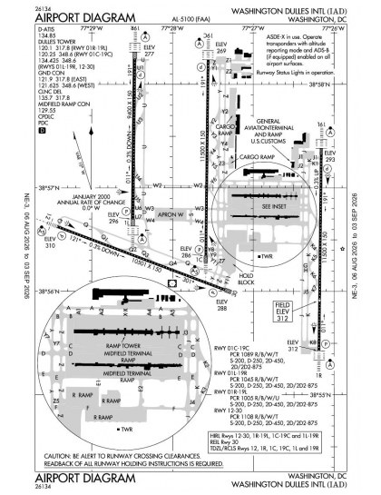
KIAD airport diagram — runways, taxiways and ramp layout
KIAD airport diagram The official FAA airport diagram — runways, taxiways, ramp layout and hold-short positions. Download PDF

28 published instrument approaches: 13 ILS approaches including CAT II/III minima, 15 RNAV (GPS), serving 8 runway ends.

All 59 KIAD charts in one download Every approach, departure, arrival and minimums page for this airport, sorted into folders, as a single ZIP. Taken one at a time on the free tier, 59 charts is roughly 6 min of downloading — they queue one behind another.
PRO members only

Instrument approach procedures

ChartAmendment
ILS OR LOC RWY 01C chart previewILS OR LOC RWY 01C3BPDF
ILS OR LOC RWY 01L chart previewILS OR LOC RWY 01L2APDF
ILS OR LOC RWY 01R chart previewILS OR LOC RWY 01R25APDF
ILS OR LOC RWY 19C chart previewILS OR LOC RWY 19C26APDF
ILS OR LOC RWY 19L chart previewILS OR LOC RWY 19L16APDF
ILS OR LOC RWY 19R chart previewILS OR LOC RWY 19R2PDF
ILS OR LOC/DME RWY 12 chart previewILS OR LOC/DME RWY 129EPDF
ILS RWY 01C (SA CAT II) chart previewILS RWY 01C (SA CAT II)3BPDF
ILS RWY 01L (CAT II - III) chart previewILS RWY 01L (CAT II - III)2APDF
ILS RWY 01R (CAT II - III) chart previewILS RWY 01R (CAT II - III)25APDF
ILS RWY 19C (CAT II - III) chart previewILS RWY 19C (CAT II - III)26APDF
ILS RWY 19L (SA CAT II) chart previewILS RWY 19L (SA CAT II)16APDF
ILS RWY 19R (CAT II - III) chart previewILS RWY 19R (CAT II - III)2PDF
RNAV (GPS) RWY 12 chart previewRNAV (GPS) RWY 121FPDF
RNAV (GPS) Y RWY 01C chart previewRNAV (GPS) Y RWY 01C2APDF
RNAV (GPS) Y RWY 01L chart previewRNAV (GPS) Y RWY 01L1APDF
RNAV (GPS) Y RWY 01R chart previewRNAV (GPS) Y RWY 01R2APDF
RNAV (GPS) Y RWY 19C chart previewRNAV (GPS) Y RWY 19C4PDF
RNAV (GPS) Y RWY 19L chart previewRNAV (GPS) Y RWY 19L3APDF
RNAV (GPS) Y RWY 19R chart previewRNAV (GPS) Y RWY 19R1PDF
RNAV (GPS) Y RWY 30 chart previewRNAV (GPS) Y RWY 300PDF
RNAV (RNP) Z RWY 01C chart previewRNAV (RNP) Z RWY 01C1BPDF
RNAV (RNP) Z RWY 01L chart previewRNAV (RNP) Z RWY 01L0APDF
RNAV (RNP) Z RWY 01R chart previewRNAV (RNP) Z RWY 01R1APDF
RNAV (RNP) Z RWY 19C chart previewRNAV (RNP) Z RWY 19C1PDF
RNAV (RNP) Z RWY 19L chart previewRNAV (RNP) Z RWY 19L1APDF
RNAV (RNP) Z RWY 19R chart previewRNAV (RNP) Z RWY 19R0PDF
RNAV (RNP) Z RWY 30 chart previewRNAV (RNP) Z RWY 300APDF

Departure procedures

ChartAmendment
BUNZZ THREE (RNAV) chart previewBUNZZ THREE (RNAV)PDF
CAPITAL ONE chart previewCAPITAL ONEPDF
CAPITAL ONE, CONT.1 chart previewCAPITAL ONE, CONT.1PDF
CLTCH THREE (RNAV) chart previewCLTCH THREE (RNAV)PDF
JCOBY FOUR (RNAV) chart previewJCOBY FOUR (RNAV)PDF
JDUBB FOUR (RNAV) chart previewJDUBB FOUR (RNAV)PDF
JERES TWO (RNAV) chart previewJERES TWO (RNAV)PDF
MCRAY TWO (RNAV) chart previewMCRAY TWO (RNAV)PDF
RNLDI FOUR (RNAV) chart previewRNLDI FOUR (RNAV)PDF
SCRAM SIX (RNAV) chart previewSCRAM SIX (RNAV)PDF
WOOLY TWO (RNAV) chart previewWOOLY TWO (RNAV)PDF

Arrival procedures (STAR)

ChartAmendment
CAVLR SEVEN (RNAV) chart previewCAVLR SEVEN (RNAV)PDF
COATT FIVE chart previewCOATT FIVEPDF
DELRO FIVE chart previewDELRO FIVEPDF
GIBBZ SIX (RNAV) chart previewGIBBZ SIX (RNAV)PDF
GIBBZ SIX (RNAV), CONT.1 chart previewGIBBZ SIX (RNAV), CONT.1PDF
HYPER ONE (RNAV) chart previewHYPER ONE (RNAV)PDF
HYPER ONE (RNAV), CONT.1 chart previewHYPER ONE (RNAV), CONT.1PDF
HYPER ONE (RNAV), CONT.2 chart previewHYPER ONE (RNAV), CONT.2PDF
PRIVO THREE chart previewPRIVO THREEPDF
PRIVO THREE, CONT.1 chart previewPRIVO THREE, CONT.1PDF
PRTZL TWO (RNAV) chart previewPRTZL TWO (RNAV)PDF
PRTZL TWO (RNAV), CONT.1 chart previewPRTZL TWO (RNAV), CONT.1PDF
PRTZL TWO (RNAV), CONT.2 chart previewPRTZL TWO (RNAV), CONT.2PDF
SELINSGROVE SIX chart previewSELINSGROVE SIXPDF
WAYNZ TWO (RNAV) chart previewWAYNZ TWO (RNAV)PDF
WAYNZ TWO (RNAV), CONT.1 chart previewWAYNZ TWO (RNAV), CONT.1PDF
WIGOL THREE (RNAV) chart previewWIGOL THREE (RNAV)PDF

Takeoff and alternate minimums

ChartAmendment
TAKEOFF MINIMUMS chart previewTAKEOFF MINIMUMSPDF
ALTERNATE MINIMUMS chart previewALTERNATE MINIMUMSPDF

Minimums pages cover a whole volume, so the same document is shared by every airport in it.

KIAD airport information

Control tower
Yes
Attendance
Continuous
ARTCC
Washington Center
Flight service
Leesburg
NOTAM facility
IAD (NOTAM-D available)
Magnetic variation
10W
Beacon
White-green (lighted land airport), sunset to sunrise
Wind indicator
Lighted
ARFF index
Index E
Fuel
100LL avgas, Jet A
Airframe service
Major
Powerplant service
Major
Bottled oxygen
High
Parking
Tie-downs
Landing fee
Yes
Customs
Landing rights airport
Activated
November 1962
Airport area
13,000 acres
Ownership
Publicly owned
Sectional
Washington
Last FAA inspection
2025-11-17

From the FAA NASR 28-day subscription, cycle 6 Aug 2026.

KIAD radio frequencies

ServiceFrequencyCall sign
UNICOM122.95
Tower120.1Rwy 01r/19l120.25Rwy 01c/19c134.425Rwy 01l/19r, Rwy 12/30Dulles
Ground121.625West121.9EastDulles
Clearance delivery135.7Dulles
ATIS134.85Dulles
Approach120.45241-330126.1331-090128.525091-240Dulles
Departure125.05300-010126.65190-300Dulles
Emergency121.5Dulles

Civil VHF frequencies from the FAA NASR 28-day subscription. Discrete sector and military frequencies are not listed.

Runways

11,500 × 150 ft01C19C11,500 × 150 ft01R19L10,501 × 150 ft12309,400 × 150 ft01L19RN5,000 ft
Runway layout at KIAD, drawn to scale from FAA published runway-end coordinates and true alignments. Runways served by an ILS are highlighted.
RunwayLengthWidth SurfaceLighting
01C/19C11,500 ft150 ftConcrete ExcellentHigh intensity
  01C 1°TILS · PAPI (4-box) 3° · MALSR approach lighting
  19C 181°TILS · PAPI (4-box) 3° · ALSF-2 approach lighting
01R/19L11,500 ft150 ftConcrete GoodHigh intensity
  01R 1°TILS/DME · PAPI (4-box) 3° · ALSF-2 approach lighting
  19L 181°TILS/DME · PAPI (4-box) 3° · ALSF-2 approach lighting
12/3010,501 ft150 ftConcrete GoodHigh intensity
  12 111°TILS · PAPI (4-box) 3° · MALSR approach lighting
  30 291°TPAPI (4-box) 3°
01L/19R9,400 ft150 ftConcrete ExcellentHigh intensity
  01L 1°TILS/DME · PAPI (4-box) 3° · ALSF-2 approach lighting
  19R 181°TILS/DME · PAPI (4-box) 3° · ALSF-2 approach lighting

Runway and approach-aid data from the FAA NASR 28-day subscription.

Where KIAD is

Latitude, longitude38.9474560, -77.4599290
Elevation312 ft
From Washington20 nm W

Paste the coordinates into a simulator’s world map to drop straight onto the field.

FAA remarks for KIAD

  • LOCATED IN BOTH FAIRFAX COUNTY VA AND LOUDOUN COUNTY VA.
  • PCR VALUE: 1089/R/B/W/T
  • PCR VALUE: 1045/R/B/W/T
  • PCR VALUE: 1005/R/B/W/U
  • PCR VALUE: 1108/R/B/W/T
  • ITNRNT ACFT CTC FBO ON 122.95 OR 129.77 FOR SVCS.
  • ACR PUSH BACKS & PWR FM ALL APRON PSNS REQUIRE CLNC FM MWAA RAMP TWR.
  • LARGE FLOCKS OF BIRDS ON & INVOF ARPT/DEER INVOF ARPT.
  • DURING PERIODS OF ACFT SATURATION LONG TERM PARKING MAY NOT BE AVAILABLE. SERVICES FOR FUEL AND GO ONLY WILL BE AVAILABLE.
  • FLIGHT TRAINING BETWEEN 2200-0700 IS PROHIBITED.
  • TAXILANE 'C' ACTIVE; PUSHBACK CLNCS ON NORTH SIDE OF MIDFIELD TERMINAL ARE ONTO TAXILANE 'D' ONLY UNLESS OTHERWISE AUTH.
  • ALL AIRCRAFT WITH WINGSPAN EXCEEDING 118 FT ARE RESTRICTED FROM USING TAXILANE A BTN A1 & A5.
  • RUNUP BLX FOR RWY 30 DSGND AS NON-MOVEMENT AREA.
  • ALL 180 DEG TURNS OUT OF APRON POSITIONS SHALL BE MADE USING MINIMUM POWER.
  • LDG FEE. FLIGHT NOTIFICATION SERVICE (ADCUS) AVBL. NOTE: SEE SPECIAL NOTICES --CONTINUOUS POWER FACILITIES.
  • TXL E1 CLSD TO ACFT WINGSPAN MORE THAN 118 FT.
  • B747-8 RESTRICTED TO MAXIMUM TAXI SPEED 17 KTS (20 MPH) ON TWY J.
  • ENGINE RUN-UPS BTW 2200L & 0700L REQUIRE PRIOR APPROVAL FM ARPT OPS.
  • RWY 30 DEPARTURES USE UPPER ANTENNA FOR ATC COMMUNICATIONS.
  • RWY STATUS LGTS ARE IN OPN.
  • PILOTS CONDUCTING EFVS OPS; BE AWARE LED ALS IN USE RWY 01C.
  • COCKPIT OVER CNTRLN TAXI PROHIBITED AT TWY Y INT WITH TWY Y11. JUDGMENTAL OVERSTEER RQRED.

Published verbatim from the FAA NASR subscription. Abbreviations are the FAA's own.

Approach and runway coverage

Instrument coverage extends to all eight runway ends rather than concentrating on selected alignments. The mix of ILS, RNAV (GPS) and localiser procedures provides several approach forms, while six ILS procedures include CAT II/III minima. Three parallel 01/19 runways are joined by runway 12/30; every runway is at least 9,400 ft long, with two extending to 11,500 ft, so substantial runway length is available across the full configuration.

Regional chart context

Among nearby fields, Ronald Reagan Washington National has the closest comparable breadth of published procedures, while Montgomery County Airpark has a much thinner chart set. The Washington Sectional supplies wider-area VFR context, the Baltimore-Washington Terminal Area Chart adds a more detailed terminal view, and the helicopter route chart shows the specialised rotary-wing route structure around the Baltimore-Washington area.

Airports near KIAD

IDAirportCity DistanceCharts
KJYOLeesburg ExecLEESBURG, VA9 nm NW23
KHEFWashington Manassas/Harry P Davis FldWASHINGTON, DC14 nm S29
KGAIMontgomery County AirparkGAITHERSBURG, MD19 nm NE11
KDAADavison AAFFORT BELVOIR, VA19 nm SE16
KDCARonald Reagan Washington NtlWASHINGTON, DC21 nm E48
W50DavisLAYTONSVILLE, MD23 nm NE2
KHWYWarrenton/FauquierWARRENTON, VA25 nm SW16
KCGSCollege ParkCOLLEGE PARK, MD25 nm E4

VFR charts covering KIAD

Common questions about KIAD

What charts are available for KIAD?

59 current FAA charts for Washington Dulles Intl, including 28 instrument approachs, 11 departure procedures, 17 arrival procedures, 1 airport diagram. All are free to download as PDFs from this page, from the 6 August 2026 cycle.

What are the radio frequencies for KIAD?

Tower 120.1, 120.25, 134.425; Ground 121.625, 121.9; ATIS 134.85; UNICOM 122.95; Clearance delivery 135.7. Full civil VHF list, with sector notes, is in the frequencies table on this page — from the FAA NASR subscription.

How long is the runway at KIAD?

Washington Dulles Intl has 4 runways. The longest is 01C/19C at 11,500 ft by 150 ft, concrete. Full runway dimensions, lighting and approach aids are listed on this page.

Does KIAD have an ILS approach?

Yes — 13 ILS procedures are published, including CAT II/III minima. In total KIAD has 28 published instrument approaches, of which 15 are RNAV (GPS).

Where can I download the KIAD airport diagram?

The official FAA airport diagram for Washington Dulles Intl is free to download at the top of this page. It shows runways, taxiways, ramp layout and hold-short positions, and is reissued every 28 days.

Does KIAD have CAT II or CAT III approaches?

Yes. 6 of the published ILS procedures carry CAT II/III minima, which allow approaches in lower visibility than a standard CAT I ILS. Those plates are listed separately in the approach table above, marked CAT II or CAT III in the chart name.

Is KIAD a towered airport?

Yes. Washington Dulles Intl has an operating control tower, within Washington Center's airspace. Tower, ground and clearance frequencies are listed on this page.

How many runways does KIAD have?

4, which is why the chart set is as large as it is — each runway end that supports an instrument approach needs its own plates. The runway diagram on this page shows the layout to scale.

Are these KIAD charts current?

They are from the FAA cycle effective 6 August 2026, which is superseded on 3 September 2026. We publish each new cycle on its effective date. They are for flight simulation and reference only — not for real-world navigation.

Wider chart sets

Bulk archives are a PRO benefit. Individual charts are free for everyone, always.

Flying into KIAD? PRO members take all 59 charts as one ZIP instead of 59 separate downloads, at full line speed with no cap — plus every chart family archive and all 24,000+ add-ons in the library.

Go PRO

Not for navigation. For flight simulation and reference use only. Procedures are superseded on a 28-day cycle — obtain current official charts from the FAA for real-world flight.

FAA public-domain products, mirrored unmodified. Fly Away Simulation is not affiliated with or endorsed by the FAA. Chart licensing and terms.