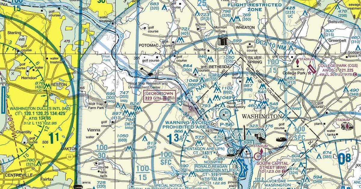
Official FAA digital chart — free GeoTIFF and PDF download
| Format | What you get | Size | |
|---|---|---|---|
| GeoTIFF | Georeferenced raster at 300 dpi, with world file and FGDC metadata | 45.6 MB | Download |
| Print-ready chart, no georeferencing | 94.5 MB | Download |
Not for navigation. For flight simulation and reference use only. Check the effective dates above, and obtain official charts from the FAA for real-world flight.

These are big files. This chart alone is 94.5 MB. Guest downloads are rate limited; PRO members get full-speed, unthrottled downloads across every chart and all 24,000+ add-ons in the library.
Go PROFrom the Shenandoah Valley to the Delmarva Peninsula, this sheet spans the Baltimore–Washington corridor and the upper Chesapeake Bay. Its coverage includes northern Virginia, central Maryland, southern Pennsylvania, eastern West Virginia and western Delaware.
The landscape changes markedly from west to east. Blue Ridge ridges and folded Appalachian terrain give way to rolling Piedmont, then to the flatter Atlantic coastal plain. Around the Chesapeake, broad water, branching rivers and deeply indented shorelines create a distinctive contrast with the dense metropolitan corridor.
Routes continuing east move towards the Philadelphia Terminal Area Chart, while the New York sheet adjoins to the north-east. The Pittsburgh sheet provides the corresponding continuation to the north-west. These connections are most relevant for longer routes crossing beyond the Chesapeake region or following the Appalachian corridor away from the chart’s western and northern margins.
| ID | Airport | City | Elev | Rwys | Longest |
|---|---|---|---|---|---|
| KIAD IAD | Washington Dulles Intl | WASHINGTON, DC | 312 ft | 4 | 11,500 ft |
| KBWI BWI | Baltimore/Washington Intl Thurgood Marshall | BALTIMORE, MD | 143 ft | 3 | 10,503 ft |
| KMRB MRB | Eastern Wv Rgnl/Shepherd Fld | MARTINSBURG, WV | 564 ft | 1 | 8,815 ft |
| KDCA DCA | Ronald Reagan Washington Ntl | WASHINGTON, DC | 14 ft | 4 | 7,169 ft |
| KHGR HGR | Hagerstown Rgnl/Richard A Henson Fld | HAGERSTOWN, MD | 703 ft | 2 | 7,000 ft |
| KMTN MTN | Martin State | BALTIMORE, MD | 22 ft | 2 | 6,999 ft |
| KHEF HEF | Washington Manassas/Harry P Davis Fld | WASHINGTON, DC | 192 ft | 2 | 6,200 ft |
| KRMN RMN | Washington Exec/Stafford Rgnl | STAFFORD, VA | 219 ft | 1 | 6,000 ft |
| KFDK FDK | Frederick Muni | FREDERICK, MD | 308 ft | 2 | 5,819 ft |
| KESN ESN | Easton/Newnam Fld | EASTON, MD | 72 ft | 2 | 5,500 ft |
| KJYO JYO | Leesburg Exec | LEESBURG, VA | 389 ft | 1 | 5,500 ft |
| KOKV OKV | Winchester Rgnl | WINCHESTER, VA | 726 ft | 1 | 5,498 ft |
| 2W6 | St Mary'S County Rgnl | LEONARDTOWN, MD | 141 ft | 1 | 5,350 ft |
| KDMW DMW | Carroll County Rgnl/Jack B Poage Fld | WESTMINSTER, MD | 789 ft | 1 | 5,100 ft |
| KCJR CJR | Culpeper Rgnl | CULPEPER, VA | 315 ft | 1 | 5,000 ft |
| KHWY HWY | Warrenton/Fauquier | WARRENTON, VA | 336 ft | 1 | 5,000 ft |
| W35 | Potomac Airpark | BERKELEY SPRINGS, WV | 412 ft | 1 | 4,979 ft |
| KEVY EVY | Summit | MIDDLETOWN, DE | 69 ft | 2 | 4,488 ft |
| KCGE CGE | Cambridge-Dorchester Rgnl | CAMBRIDGE, MD | 19 ft | 1 | 4,477 ft |
| KGAI GAI | Montgomery County Airpark | GAITHERSBURG, MD | 538 ft | 1 | 4,202 ft |
| 2W5 | Maryland | INDIAN HEAD, MD | 175 ft | 1 | 3,740 ft |
| N57 | New Garden | TOUGHKENAMON, PA | 435 ft | 1 | 3,693 ft |
| 0W3 | Harford County | CHURCHVILLE, MD | 411 ft | 1 | 3,354 ft |
| KRJD RJD | Gooden Airpark | RIDGELY, MD | 64 ft | 1 | 3,214 ft |
| KOMH OMH | Orange County | ORANGE, VA | 464 ft | 1 | 3,200 ft |
| KLUA LUA | Luray Caverns | LURAY, VA | 902 ft | 1 | 3,126 ft |
| KFRR FRR | Front Royal-Warren County | FRONT ROYAL, VA | 703 ft | 1 | 3,008 ft |
| W48 | Essex Skypark | BALTIMORE, MD | 14 ft | 2 | 3,000 ft |
| KFME FME | Fort Meade Exec | FORT MEADE (ODENTON), MD | 149 ft | 1 | 3,000 ft |
| MD1 | Massey Aerodrome | MASSEY, MD | 73 ft | 1 | 3,000 ft |
| 58M | Claremont | ELKTON, MD | 106 ft | 1 | 2,989 ft |
| KCGS CGS | College Park | COLLEGE PARK, MD | 48 ft | 1 | 2,980 ft |
| 8W2 | New Market | NEW MARKET, VA | 962 ft | 1 | 2,920 ft |
| KEZF EZF | Shannon | FREDERICKSBURG, VA | 85 ft | 3 | 2,902 ft |
| W29 | Bay Bridge | STEVENSVILLE, MD | 14 ft | 1 | 2,714 ft |
| W73 | Mid Atlantic Soaring Center | FAIRFIELD, PA | 573 ft | 1 | 2,700 ft |
| KVKX VKX | Potomac Airfield | FRIENDLY, MD | 117 ft | 1 | 2,665 ft |
| W50 | Davis | LAYTONSVILLE, MD | 609 ft | 1 | 2,600 ft |
| KANP ANP | Lee | ANNAPOLIS, MD | 34 ft | 1 | 2,505 ft |
| W00 | Freeway | BOWIE, MD | 168 ft | 1 | 2,420 ft |
| 3W3 | Kentmorr Airpark | STEVENSVILLE, MD | 10 ft | 1 | 2,400 ft |
| KGVE GVE | Gordonsville Muni | GORDONSVILLE, VA | 452 ft | 1 | 2,300 ft |
| W42 | Fallston | FALLSTON, MD | 460 ft | 1 | 2,200 ft |
| 2W2 | Clearview Airpark | WESTMINSTER, MD | 798 ft | 1 | 1,840 ft |
| 0P2 | Shoestring Aviation Airfield | STEWARTSTOWN, PA | 1,000 ft | 2 | 1,000 ft |
45 public-use airports within this chart's coverage, ordered by runway length. A further 149 private and restricted landing facilities are not listed. Source: FAA NASR 28-day subscription.
Approach plates and airport diagrams for every airport in the states this sheet covers:
It spans 38.1°N to 39.8°N and 78.7°W to 75.7°W. Airports on the sheet fall within District of Columbia, Delaware, Maryland, Pennsylvania, Virginia and West Virginia. The full list of public-use airports within its coverage is on this page.
Take the GeoTIFF if you are loading the chart into moving-map software or a flight planner — it is georeferenced, so the software can place it correctly on a map, and it ships with a world file and FGDC metadata at 300 dpi (45.6 MB). Take the PDF to print it or read it on a second screen (94.5 MB); it is the same chart without georeferencing.
This is the FAA edition effective 3 September 2026, which is superseded on 29 October 2026. Visual charts are reissued every 56 days and we publish each new edition on the day it takes effect. It is for flight simulation and reference only — not for real-world navigation.
Philadelphia to the east, New York to the north-east and Pittsburgh to the north-west. Each is linked from this page, so a route running off one edge can be continued on the next sheet.
Yes, with no account required. FAA charts are United States Government works and are not subject to copyright protection in the US under 17 U.S.C. § 105. Guest downloads are speed-capped, so a sheet this size takes a while; PRO members download at full line speed and can take the whole family as one archive.

FAA public-domain products, mirrored unmodified. Fly Away Simulation is not affiliated with or endorsed by the FAA. Chart licensing and terms.

