Terminal Procedures

KLFI — Langley AFB

HAMPTON, VA · 15 FAA charts · cycle 6 Aug 2026

FAA LFIElevation 8 ft1 runwayLongest 10,002 ftToweredVolume NE-3Not for navigation
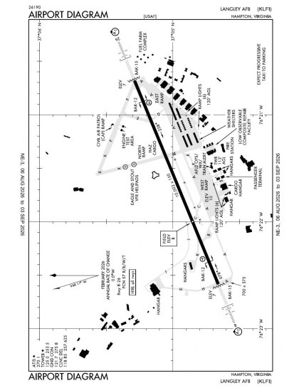
KLFI airport diagram — runways, taxiways and ramp layout
KLFI airport diagram The official FAA airport diagram — runways, taxiways, ramp layout and hold-short positions. Download PDF

10 published instrument approaches: 4 ILS approaches, 2 RNAV (GPS), serving 2 runway ends.

All 15 KLFI charts in one download Every approach, departure, arrival and minimums page for this airport, sorted into folders, as a single ZIP. Taken one at a time on the free tier, 15 charts is roughly 2 min of downloading — they queue one behind another.
PRO members only

Instrument approach procedures

ChartAmendment
HI-ILS OR LOC Z RWY 08 chart previewHI-ILS OR LOC Z RWY 08PDF
HI-ILS OR LOC Z RWY 26 chart previewHI-ILS OR LOC Z RWY 26PDF
HI-TACAN Z RWY 08 chart previewHI-TACAN Z RWY 08PDF
HI-TACAN Z RWY 26 chart previewHI-TACAN Z RWY 26PDF
ILS OR LOC Y RWY 08 chart previewILS OR LOC Y RWY 08PDF
ILS OR LOC Y RWY 26 chart previewILS OR LOC Y RWY 26PDF
RNAV (GPS) RWY 08 chart previewRNAV (GPS) RWY 08PDF
RNAV (GPS) RWY 26 chart previewRNAV (GPS) RWY 26PDF
TACAN Y RWY 08 chart previewTACAN Y RWY 08PDF
TACAN Y RWY 26 chart previewTACAN Y RWY 26PDF

Arrival procedures (STAR)

ChartAmendment
KOHLS ONE (RNAV) chart previewKOHLS ONE (RNAV)PDF
OUTLA ONE (RNAV) chart previewOUTLA ONE (RNAV)PDF
OUTLA ONE (RNAV), CONT.1 chart previewOUTLA ONE (RNAV), CONT.1PDF

Takeoff and alternate minimums

ChartAmendment
TAKEOFF MINIMUMS chart previewTAKEOFF MINIMUMSPDF

Minimums pages cover a whole volume, so the same document is shared by every airport in it.

KLFI airport information

Control tower
Yes
Attendance
All mon-fri 1100-0300z++
ARTCC
Washington Center
Flight service
Leesburg
NOTAM facility
LFI (NOTAM-D available)
Magnetic variation
10W
Beacon
White-green (lighted land airport), sunset to sunrise
Wind indicator
Yes
Airframe service
Major
Powerplant service
Major
Bottled oxygen
None
Customs
Landing rights airport
Activated
April 1943
Ownership
Privately owned
Sectional
Washington

From the FAA NASR 28-day subscription, cycle 6 Aug 2026.

KLFI radio frequencies

ServiceFrequencyCall sign
Tower125.0Langley
Ground121.7Langley
Clearance delivery118.85Langley
Approach124.9311-009125.7311-009127.9180-310134.875010-179Langley
Emergency121.5Langley

Civil VHF frequencies from the FAA NASR 28-day subscription. Discrete sector and military frequencies are not listed.

Runways

10,002 × 150 ft0826N3,000 ft
Runway layout at KLFI, drawn to scale from FAA published runway-end coordinates and true alignments. Runways served by an ILS are highlighted.
RunwayLengthWidth SurfaceLighting
08/2610,002 ft150 ftConcreteHigh intensity
  08ILS · PAPI (4-box) 2.8° · ALSF-1 approach lighting
  26LOC/GS · PAPI (4-box) 2.8° · ALSF-1 approach lighting

Runway and approach-aid data from the FAA NASR 28-day subscription.

Where KLFI is

Latitude, longitude37.0828890, -76.3605440
Elevation8 ft
From Hampton3 nm N

Paste the coordinates into a simulator’s world map to drop straight onto the field.

FAA remarks for KLFI

  • ARFF IS CAT 8 WITH 8100 GAL OF CAPABILITY. STEADY ARFF COND FOR LANGLEY AFB IS OPTIMUM LEVEL OF SVC (OLS) FOR CAT 1-10. _.
  • RWY 08/26 THR LGT GATED, MID 70 FT INOP/REMOVED.
  • A-GEAR: BAK-15 CABLE ALWAYS IN PLACE RWY 26 OVRN AND NET RAISED AT PILOTS REQ. BAK-12B(B) PENDANT CABLE ALWAYS IN PLACE. BAK-12B EXTN.
  • JASU: 2(M32A-60) MC-11) 4(A/M 32A-86).
  • FUEL: A++. EXPECT UP TO 30 MIN DELAY.
  • OIL: O-133-148-156 SOAP.
  • TRAN ALERT: OPR 1130-0430Z++ WKD, CLSD WKEND, HOL, AND ACC DOWN DAYS. EXP PROGRESSIVE TAXI TO PRK. FLW ME SVC AVBL UPON REQ.
  • RSTD: PPR CTC BASE OPS 1030-0430Z++ DSN 574-2504, C7577642504. PPR VALID +/- 1 HR OF APV TIME DUR AFLD OPRNG HRS. IF OUTSIDE OF APV TIME SLOT CTC BASE OPS TO UPDATE PPR. ONLY 1 F/W ACFT AUTH FR 1300-1400Z++. TRANSPORT/DV ACFT CTC BASE OPS 20 MIN PRIOR LDG.
  • CAUTION: INST IFR AND VFR HI PERFORMANCE FTR TFC WITHIN THE CLASS D AIRSPACE: EXTV UNCTL GENERAL AVN TFC BLW 3000 FT OVER JAMES RIVER AND CHESAPEAKE BAY. DEP TFC DO NOT EXCEED 1000 FT ON CLIMBOUT TIL DEP END OF RWY.
  • CAUTION: LASER LGT BEAM HAZ TO DRCT VISUAL OBSN WILL BE CONDUCTED AT NASA LANGLEY RESEARCH CNTR WITHIN 1/2 NM RAD OF 37 DEG 06.3 MIN N 76 DEG 22.7 MIN W. STRONG CAUTION IS ADVS. LASER BEAM MAY BE INJURIOUS TO PILOTS/PAX EYES WITHIN ALL ALT OF LGT SOURCE. CK NOTAM FOR DATE/TIME/DURATION/AFFECTED ALT.
  • CAUTION: WX OBSN SITE LCTD 080-250 DUE TO BLDG.
  • CAUTION: WIND SHEAR COND MAY EXIST ON RWY 26 THRU SHORT FINAL AND TD, THAT ARE PREVALENT, UNDETECTABLE AND OFTEN UNRPT. INCREASED POTENTIAL FOR HYDROPLANING DUE TO EXCESSIVE RUBBER BUILD-UP. ALS NON-FRANGIBLE. AFLD GRASS CUTTING CONDUCTED FR MAR-NOV, EXP INCREASED BIRD ACT IN VCNTY OF MOWERS.
  • TFC PAT: OVERHEAD 3000 FT AT 5 DME DESCENDING TO 1500 FT BY 3 DME, RGT BREAK RWY 26, LEFT BREAK RWY 08. RECTANGULAR 1000 FT RGT TFC RWY 26, LEFT TFC RWY 08.
  • NS ABTMT: QUIET HR 0330-1100Z++ WKD, 0330-1300Z++ WKEND AND HOL, WAIVERS CTC COMD POST DSN DSN 574-5411.
  • MISC: AFLD OPS DSN 574-2504, C757-764-2504. AFLD MGR DSN 574-2508. DD FORM 1801 RQR 90 MIN PRIOR TO ETD. RWY 08/26 GROOVED. ACC FTR ACFT EXP REDUCED RWY SEPARATION: DAY/VFR, SIMILAR ACFT 3000 FT, DISSIMIILAR TYPE ACFT 6000 FT. NGT 6000 FT ALL ACFT.
  • MISC: TRAN ACFT NOTIFY TWR ON INITIAL CTC IF REDUCED RWY SEPARATION IS NOT DESIRED. AFLD OPS DOES NOT HAVE COMSEC OR FACILITY TO STORE FOR TRAN CREWS; TRAN CREWS SHOULD PLAN TO ARR WITH APPROPRIATE AMOUNT OF COMSEC TO COMPLETE MSN. COMSEC CAN BE STORED AT 1FW COMD POST; DSN 574-5411 C757-764-2504.
  • A: PRK, REFUEL AND MAINT AVBL ON AF RAMP. ACFT WITH FIREARMS CALL PTD TO ARNG FOR SECURITY.
  • NASA: ACFT INTENDING TO OPERATE FROM NASA RAMP SHALL CONTACT NASA FLIGHT OPERATIONS AT LARC-DL-FLTOPS@MAIL.NASA.GOV TO ARRANGE FOR APPROVAL AND SUPPORT PRIOR TO ARRIVAL. ADDITIONALLY OBTAIN PPR FROM 1 OSS/OSA AT C757-764-2504 FOR LANDING AT KLFI. SVC NOT AVBL FOR NON-NASA ACFT. NO ORGANIC SUPPORT FOR LARGE TRANSPORT CATEGORY AIRCRAFT (POWER, FUEL, LAV, STEPS). HOWEVER USAF ELEMENTS MAY BE ABLE TO PROVIDE SUPPORT WITH SUFFICIENT ADVANCE NOTICE. TAXIWAY JULIET INCREASED FOD HAZARD AND REDUCED PCN DUE TO DEGRADING PAVEMENT CONDITIONS. ACFT WITH ACN GREATER THAN 24 OR WINGSPAN GREATER THAN 80 FT USE TAXIWAY H. TAXIWAY J LIMITED FOR NIGHT AND IFR CONDITIONS DUE TO LACK OF TAXIWAY EDGE LIGHTING SYSTEM. CONTROL OF PERIMETER ROAD STREET LIGHTS TO STOP VEHICULAR TRAFFIC IS THREE CLICKS ON 123.375 FOR TAXIWAY J AND FIVE CLICKS FOR TAXIWAY H. ONLY NASA BE200, T38, OV10 AND T34 CAN OPR ON TWY 'J'.
  • PMSV METRO: ALTN PMSV IS MCGUIRE AFB ON 239.8 WX SVC AVBL H24 AT DSN 574-5908/5907,C757-764-5908/5907. AN/FMQ-19 AUTOMATED OBSERVING SYS IN USE; AUGMENTED BY HUMAN OBSN WHEN NEC. DUR WX FLT CLOSURE OR EVAC, REMOTE BRIEFING SVC AVBL FROM 15 OP WX SQ (SCOTT AFB) DSN 576-9755 OR 576-9701 THRU 9704, C618-256-9755 OR 618-256-9701 THRU 9704.
  • CAUTION: ATC WILL RELAY TWR PREVAILING VIS, SECTOR VIS, LCL PIREPS OR AN OCCURRENCE OF PREV UNREPORTED WX COND THAT COULD AFFECT OPS TO WX FLT.
  • REMARKS: TWY 'J' IS RESTRICTED TO ACFT WITH TOTAL WINGSPAN OF 80 FT OR LESS AND 100000 LBS. OR LESS GROSS WEIGHT.
  • RSTD: ACC RSRS APPLIED TO ACC ACFT ONLY.
  • WGT BEARING WAIVERS CTC AFLD MANAGER DSN 574-2508.
  • CAUTION: USE EXTREME CTN FOR UAS OPS AT NASA LANGLEY RESEARCH CNTR FR SFC-400 FT WITHIN 1/2 NM RAD OF 370607.51N/762313.88W.
  • A-G O/S FOR MAINT: EAST BAK-12 TUE 1030-1130Z++, WEST BAK-12 WED 1030-1130Z++.
  • REMARKS: OPR 1100-0300Z++ MON-FRI, OPEN WKEND TO SUPPORT REG SKED DRILL (RSD)/GUARD WKEND ONCE A MONTH; CLSD FEDERAL HOL AND ACC DOWN DAYS UNLESS OPS APV BY 1 FW/CC. CTC COMD POST (CP) DSN 574-5411 OR C757-764-5411 OUTSIDE OF OPR HR.
  • MISC: TOWING CAPES LIMITED TO UNIVERSAL TOWBAR ONLY.
  • CAUTION: BASH PHASE I IN EFF 16 NOV - 14 FEB AND 01 APR - 14 SEP. BASH PHASE II IN EFF 15 FEB - 31 MAR AND 15 SEP - 15 NOV. CTC BASE OPS FOR CURRENT BASH COND.
  • REMARKS: COMMUNICATION-NASA OPS UNMTO C757-864-3887.
  • RSTD: V/STOL AIRCRAFT, VERTICAL TKOF, VERTICAL LOW APCH, AND VERTICAL LDG ARE PROHIBITED AT THE AFLD.

Published verbatim from the FAA NASR subscription. Abbreviations are the FAA's own.

Approach coverage

Langley AFB’s single 08/26 runway is served at both ends by ten approaches: four ILS, four localiser and two RNAV (GPS). Instrument coverage is therefore available in either runway direction, with several procedure types concentrated on the same 10,002 ft alignment. That length provides substantial landing and take-off distance, but there is no second runway orientation.

Coverage nearby

Newport News/Williamsburg International and Norfolk NS (Chambers Field) have similarly broad chart sets, while Norfolk International has slightly wider coverage. Norfolk NS and Felker AAF have much thinner published sets. The Washington Sectional adds the wider geographic and visual-navigation context around Hampton that the airport diagram and terminal procedures do not provide.

Airports near KLFI

IDAirportCity DistanceCharts
KPHFNewport News/Williamsburg IntlNEWPORT NEWS, VA7 nm NW16
KNHUNorfolk NsNORFOLK, VA8 nm S7
KNGUNorfolk Ns (Chambers Fld)NORFOLK, VA9 nm S15
KFAFFelker AAFFORT EUSTIS, VA12 nm W5
KORFNorfolk IntlNORFOLK, VA14 nm SE18
KPVGHampton Roads ExecNORFOLK, VA19 nm S8
W94Camp Peary Lndg StripWILLIAMSBURG, VA19 nm NW4
KJGGWaltrip Williamsburg Exec AirportWILLIAMSBURG, VA19 nm NW5

VFR charts covering KLFI

Common questions about KLFI

What charts are available for KLFI?

15 current FAA charts for Langley AFB, including 10 instrument approachs, 3 arrival procedures, 1 airport diagram. All are free to download as PDFs from this page, from the 6 August 2026 cycle.

What are the radio frequencies for KLFI?

Tower 125.0; Ground 121.7; Clearance delivery 118.85. Full civil VHF list, with sector notes, is in the frequencies table on this page — from the FAA NASR subscription.

How long is the runway at KLFI?

Langley AFB has 1 runway. The longest is 08/26 at 10,002 ft by 150 ft, concrete. Full runway dimensions, lighting and approach aids are listed on this page.

Does KLFI have an ILS approach?

Yes — 4 ILS procedures are published. In total KLFI has 10 published instrument approaches, of which 2 are RNAV (GPS).

Where can I download the KLFI airport diagram?

The official FAA airport diagram for Langley AFB is free to download at the top of this page. It shows runways, taxiways, ramp layout and hold-short positions, and is reissued every 28 days.

Is KLFI a towered airport?

Yes. Langley AFB has an operating control tower, within Washington Center's airspace. Tower, ground and clearance frequencies are listed on this page.

Are these KLFI charts current?

They are from the FAA cycle effective 6 August 2026, which is superseded on 3 September 2026. We publish each new cycle on its effective date. They are for flight simulation and reference only — not for real-world navigation.

Wider chart sets

Bulk archives are a PRO benefit. Individual charts are free for everyone, always.

Flying into KLFI? PRO members take all 15 charts as one ZIP instead of 15 separate downloads, at full line speed with no cap — plus every chart family archive and all 24,000+ add-ons in the library.

Go PRO

Not for navigation. For flight simulation and reference use only. Procedures are superseded on a 28-day cycle — obtain current official charts from the FAA for real-world flight.

FAA public-domain products, mirrored unmodified. Fly Away Simulation is not affiliated with or endorsed by the FAA. Chart licensing and terms.