Terminal Procedures

KRDU — Raleigh-Durham Intl

RALEIGH/DURHAM, NC · 39 FAA charts · cycle 6 Aug 2026

FAA RDUElevation 435 ft3 runwaysLongest 10,000 ftToweredFuel 100LL avgas, Jet AVolume SE-2Not for navigation
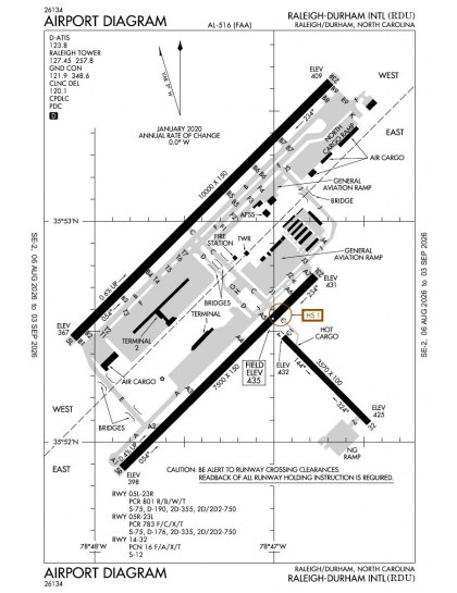
KRDU airport diagram — runways, taxiways and ramp layout
KRDU airport diagram The official FAA airport diagram — runways, taxiways, ramp layout and hold-short positions. Download PDF

15 published instrument approaches: 6 ILS approaches including CAT II/III minima, 9 RNAV (GPS), serving 5 runway ends.

All 39 KRDU charts in one download Every approach, departure, arrival and minimums page for this airport, sorted into folders, as a single ZIP. Taken one at a time on the free tier, 39 charts is roughly 4 min of downloading — they queue one behind another.
PRO members only

Instrument approach procedures

ChartAmendment
ILS OR LOC RWY 05L chart previewILS OR LOC RWY 05L6PDF
ILS OR LOC RWY 05R chart previewILS OR LOC RWY 05R31PDF
ILS OR LOC RWY 23L chart previewILS OR LOC RWY 23L10PDF
ILS OR LOC RWY 23R chart previewILS OR LOC RWY 23R12PDF
ILS RWY 05R (SA CAT I - II) chart previewILS RWY 05R (SA CAT I - II)31PDF
ILS RWY 23R (CAT II - III) chart previewILS RWY 23R (CAT II - III)12PDF
RNAV (GPS) RWY 32 chart previewRNAV (GPS) RWY 320BPDF
RNAV (GPS) Y RWY 05L chart previewRNAV (GPS) Y RWY 05L2APDF
RNAV (GPS) Y RWY 05R chart previewRNAV (GPS) Y RWY 05R4PDF
RNAV (GPS) Y RWY 23L chart previewRNAV (GPS) Y RWY 23L3PDF
RNAV (GPS) Y RWY 23R chart previewRNAV (GPS) Y RWY 23R2APDF
RNAV (RNP) Z RWY 05L chart previewRNAV (RNP) Z RWY 05L3PDF
RNAV (RNP) Z RWY 05R chart previewRNAV (RNP) Z RWY 05R3APDF
RNAV (RNP) Z RWY 23L chart previewRNAV (RNP) Z RWY 23L3PDF
RNAV (RNP) Z RWY 23R chart previewRNAV (RNP) Z RWY 23R3PDF

Departure procedures

ChartAmendment
BEXGO FIVE (RNAV) chart previewBEXGO FIVE (RNAV)PDF
HOOKZ FIVE (RNAV) chart previewHOOKZ FIVE (RNAV)PDF
HURIC FOUR (RNAV) chart previewHURIC FOUR (RNAV)PDF
LWOOD FIVE (RNAV) chart previewLWOOD FIVE (RNAV)PDF
OXFRD FIVE (RNAV) chart previewOXFRD FIVE (RNAV)PDF
PACKK NINE chart previewPACKK NINEPDF
PACKK NINE, CONT.1 chart previewPACKK NINE, CONT.1PDF
RALEIGH ONE chart previewRALEIGH ONEPDF
RALEIGH ONE, CONT.1 chart previewRALEIGH ONE, CONT.1PDF
ROZBO FIVE (RNAV) chart previewROZBO FIVE (RNAV)PDF
SHPRD FOUR (RNAV) chart previewSHPRD FOUR (RNAV)PDF

Arrival procedures (STAR)

ChartAmendment
ALDAN FOUR (RNAV) chart previewALDAN FOUR (RNAV)PDF
ALDAN FOUR (RNAV), CONT.1 chart previewALDAN FOUR (RNAV), CONT.1PDF
BLOGS THREE (RNAV) chart previewBLOGS THREE (RNAV)PDF
BRADE SIX chart previewBRADE SIXPDF
BUZZY ONE chart previewBUZZY ONEPDF
DMSTR TWO (RNAV) chart previewDMSTR TWO (RNAV)PDF
DMSTR TWO (RNAV), CONT.1 chart previewDMSTR TWO (RNAV), CONT.1PDF
TAQLE THREE (RNAV) chart previewTAQLE THREE (RNAV)PDF
TAQLE THREE (RNAV), CONT.1 chart previewTAQLE THREE (RNAV), CONT.1PDF

Takeoff and alternate minimums

ChartAmendment
TAKEOFF MINIMUMS chart previewTAKEOFF MINIMUMSPDF
ALTERNATE MINIMUMS chart previewALTERNATE MINIMUMSPDF

Minimums pages cover a whole volume, so the same document is shared by every airport in it.

Hot spots

ChartAmendment
HOT SPOT chart previewHOT SPOTPDF

KRDU airport information

Control tower
Yes
Attendance
Continuous
ARTCC
Washington Center
Flight service
Raleigh
NOTAM facility
RDU (NOTAM-D available)
Magnetic variation
9W
Beacon
White-green (lighted land airport), sunset to sunrise
Wind indicator
Lighted
ARFF index
Index D
Fuel
100LL avgas, Jet A
Airframe service
Major
Powerplant service
Major
Bottled oxygen
None
Parking
Tie-downs
Customs
Landing rights airport
Activated
April 1943
Airport area
5,000 acres
Ownership
Publicly owned
Sectional
Charlotte
Last FAA inspection
2026-06-04

From the FAA NASR 28-day subscription, cycle 6 Aug 2026.

KRDU radio frequencies

ServiceFrequencyCall sign
UNICOM122.95
Tower127.45Raleigh
Ground121.9Raleigh
Clearance delivery120.1Raleigh
ATIS123.8Raleigh
Approach124.95055-229127.675230-054Raleigh
Departure125.3055-229132.35230-054Raleigh
Emergency121.5Raleigh

Civil VHF frequencies from the FAA NASR 28-day subscription. Discrete sector and military frequencies are not listed.

Runways

10,000 × 150 ft05L23R7,500 × 150 ft05R23L3,570 × 100 ft1432N2,000 ft
Runway layout at KRDU, drawn to scale from FAA published runway-end coordinates and true alignments. Runways served by an ILS are highlighted.
RunwayLengthWidth SurfaceLighting
05L/23R10,000 ft150 ftConcrete GoodHigh intensity
  05L 45°TILS/DME · PAPI (4-box) 3° · MALSR approach lighting
  23R 225°TILS/DME · PAPI (4-box) 3° · ALSF-2 approach lighting · right-hand circuit
05R/23L7,500 ft150 ftAsphalt GoodHigh intensity
  05R 45°TILS/DME · PAPI (4-box) 3° · MALSR approach lighting · right-hand circuit
  23L 225°TILS/DME · PAPI (4-box) 3° · MALSR approach lighting
14/323,570 ft100 ftAsphalt GoodMedium intensity
  32 315°TPAPI (4-box) 3.5°

Runway and approach-aid data from the FAA NASR 28-day subscription.

Where KRDU is

Latitude, longitude35.8776390, -78.7874720
Elevation435 ft
From Raleigh/Durham9 nm NW

Paste the coordinates into a simulator’s world map to drop straight onto the field.

FAA remarks for KRDU

  • VISIBILITY OF BCN SHIELDED TO THE NORTH.
  • NO JET ENGINE MAINTENANCE RUNS BETWEEN 0000-0600.
  • PCR VALUE: 801/R/B/W/T
  • PCR VALUE: 783/F/C/X/T
  • RWY 05L/23R UNGROOVED.
  • NG PPR FOR LDG CTC V582-9181 C(919)664-9181.
  • NG 24 HR PPR FOR JET ACFT & TRANS MIL ACFT - 919-840-7510.
  • RSTD: PPR FOR ALL MILITARY AIRCRAFT F/W - R/W & UNSCHEDULED CHARTER FLIGHTS WITH 30 OR MORE PASSENGERS. 24 HR PN RQR FOR MIL PRACTICE APCH. CTC ARPT OPS 919-840-7510 OR RDU APP C919-380-3125. 24 HR PN RQR FOR PPR FOR ALL F/W AND R/W MIL ACFT GOING TO ARNG RAMP, POC C984-661-6200. OSACOM FLT DET C984-661-6202.
  • ARPT CLSD TO AIRSHIPS.
  • TWY E BEHIND SOUTH CARGO 4 & TWY J BEHIND CORPORATE HANGARS NOT VSBL FM ATCT.
  • ARNG: LTD PRK. ARNG OPS C984-661-6200. CTC FORECAST BASE 10 MIN PRIOR LDG. RAMP CLSD TO ALL F/W EXCEPT ARMY & MIL TRANSPORT WITH PPR, FACILITY HRS 1300-2130Z++ MON-FRI EXC HOL. MAKE APPT FOR AFTER DUTY HRS. OSACOM FLT DET C984-661-6202.
  • TWY F4 & F5 IS CLSD UFN.
  • ALL TDG V AIRCRAFT TXG ON TWY A ARE RSTD TO TAXI SPD OF 15 MPH.
  • APN TXL F BTN TWY T1 AND TWY T7 CLSD TO ACFT WITH WINGSPAN MORE THAN 171 FT.
  • TWY D CLSD TO ACFT WITH WINGSPAN MORE THAN 171 FT WHEN TWY G AND H ARE OCCUPIED.
  • TRML 1 ACFT MUST CTC ATC ON 121.9 PRIOR TO PUSH ONTO TWY A. TRML 2 ACFT MUST CTC RAMP TWR ON 130.175 PRIOR TO PUSH. NORTH CARGO APRON ADG IV OR V ACFT MUST CTC ATC ON 121.9 PRIOR TO PUSH.
  • TWY C BTN TWY F AND G IS RSTRD TO ACFT LESS THAN A MAX GROSS TKOF WEIGHT OF 490000 LBS.
  • TWY E CLSD TO AFCT WITH WINGSPAN MORE THAN 171 FT.

Published verbatim from the FAA NASR subscription. Abbreviations are the FAA's own.

Approach and runway coverage

Five of Raleigh-Durham’s six runway ends have published approaches, with several ends supported by more than one procedure type. The mix of ILS, localiser and RNAV (GPS) procedures provides both ground-based and satellite-based coverage, while one ILS includes CAT II/III minima. The two parallel runways offer 10,000 ft and 7,500 ft of length; the 3,570 ft crossing runway is less than half the length of the longest and is not dimensionally equivalent.

Wider chart context

Nearby fields have only five or six published charts each, making their procedure coverage substantially thinner than Raleigh-Durham’s. The Charlotte, Cincinnati and Washington sectionals supplement the terminal procedures with broader visual-navigation context across the surrounding region.

Airports near KRDU

IDAirportCity DistanceCharts
KTTARaleigh Exec Jetport At Sanford-Lee CountySANFORD, NC23 nm SW6
KLHZTriangle North ExecLOUISBURG, NC24 nm E6
KTDFRaleigh Rgnl At Person CountyROXBORO, NC26 nm N5
KJNXJohnston RgnlSMITHFIELD, NC28 nm SE6
KHRJHarnett Rgnl JetportERWIN, NC30 nm S5
KHNZHenderson/OxfordOXFORD, NC32 nm NE5
KBUYBurlington/Alamance RgnlBURLINGTON, NC35 nm W7
KSCRSiler City MuniSILER CITY, NC36 nm W4

VFR charts covering KRDU

Common questions about KRDU

What charts are available for KRDU?

39 current FAA charts for Raleigh-Durham Intl, including 15 instrument approachs, 11 departure procedures, 9 arrival procedures, 1 airport diagram. All are free to download as PDFs from this page, from the 6 August 2026 cycle.

What are the radio frequencies for KRDU?

Tower 127.45; Ground 121.9; ATIS 123.8; UNICOM 122.95; Clearance delivery 120.1. Full civil VHF list, with sector notes, is in the frequencies table on this page — from the FAA NASR subscription.

How long is the runway at KRDU?

Raleigh-Durham Intl has 3 runways. The longest is 05L/23R at 10,000 ft by 150 ft, concrete. Full runway dimensions, lighting and approach aids are listed on this page.

Does KRDU have an ILS approach?

Yes — 6 ILS procedures are published, including CAT II/III minima. In total KRDU has 15 published instrument approaches, of which 9 are RNAV (GPS).

Where can I download the KRDU airport diagram?

The official FAA airport diagram for Raleigh-Durham Intl is free to download at the top of this page. It shows runways, taxiways, ramp layout and hold-short positions, and is reissued every 28 days.

Does KRDU have CAT II or CAT III approaches?

Yes. 1 of the published ILS procedures carry CAT II/III minima, which allow approaches in lower visibility than a standard CAT I ILS. Those plates are listed separately in the approach table above, marked CAT II or CAT III in the chart name.

Is KRDU a towered airport?

Yes. Raleigh-Durham Intl has an operating control tower, within Washington Center's airspace. Tower, ground and clearance frequencies are listed on this page.

Are these KRDU charts current?

They are from the FAA cycle effective 6 August 2026, which is superseded on 3 September 2026. We publish each new cycle on its effective date. They are for flight simulation and reference only — not for real-world navigation.

Wider chart sets

Bulk archives are a PRO benefit. Individual charts are free for everyone, always.

Flying into KRDU? PRO members take all 39 charts as one ZIP instead of 39 separate downloads, at full line speed with no cap — plus every chart family archive and all 24,000+ add-ons in the library.

Go PRO

Not for navigation. For flight simulation and reference use only. Procedures are superseded on a 28-day cycle — obtain current official charts from the FAA for real-world flight.

FAA public-domain products, mirrored unmodified. Fly Away Simulation is not affiliated with or endorsed by the FAA. Chart licensing and terms.