Terminal Procedures

PHNG — Kaneohe Bay MCAS (Marion E Carl Fld)

KANEOHE, HI · 12 FAA charts · cycle 6 Aug 2026

FAA NGFElevation 23 ft1 runwayLongest 7,771 ftToweredVolume PC-1Not for navigation
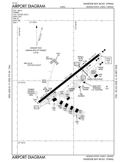
PHNG airport diagram — runways, taxiways and ramp layout
PHNG airport diagram The official FAA airport diagram — runways, taxiways, ramp layout and hold-short positions. Download PDF

5 published instrument approaches: 2 RNAV (GPS).

All 12 PHNG charts in one download Every approach, departure, arrival and minimums page for this airport, sorted into folders, as a single ZIP. Taken one at a time on the free tier, 12 charts is roughly 1 min of downloading — they queue one behind another.
PRO members only

Instrument approach procedures

ChartAmendment
COPTER TACAN RWY 22 chart previewCOPTER TACAN RWY 22PDF
HI-TACAN Y RWY 22 chart previewHI-TACAN Y RWY 22PDF
RNAV (GPS) Y RWY 22 chart previewRNAV (GPS) Y RWY 22PDF
RNAV (GPS) Z RWY 22 chart previewRNAV (GPS) Z RWY 22PDF
TACAN Z RWY 22 chart previewTACAN Z RWY 22PDF

Obstacle departure procedures

ChartAmendment
HELUX SIX (OBSTACLE) chart previewHELUX SIX (OBSTACLE)PDF
KANEOHE SIX (OBSTACLE) chart previewKANEOHE SIX (OBSTACLE)PDF
MUGGE ONE (OBSTACLE) chart previewMUGGE ONE (OBSTACLE)PDF

Takeoff and alternate minimums

ChartAmendment
TAKEOFF MINIMUMS chart previewTAKEOFF MINIMUMSPDF
RADAR MINIMUMS chart previewRADAR MINIMUMSPDF

Minimums pages cover a whole volume, so the same document is shared by every airport in it.

Hot spots

ChartAmendment
HOT SPOT chart previewHOT SPOTPDF

PHNG airport information

Control tower
Yes
Attendance
All
ARTCC
Honolulu Control Facility Center
Flight service
Honolulu
NOTAM facility
PHNG (NOTAM-D available)
Magnetic variation
10E
Beacon
Split-white-green (military airport), sunset to sunrise
Bottled oxygen
High/low
Activated
September 1946
Ownership
Privately owned
Sectional
Hawaiian Islands

From the FAA NASR 28-day subscription, cycle 6 Aug 2026.

PHNG radio frequencies

ServiceFrequencyCall sign
CTAF120.7
Approach125.0Marine Kaneohe
Emergency121.5Marine Kaneohe

Civil VHF frequencies from the FAA NASR 28-day subscription. Discrete sector and military frequencies are not listed.

Runways

7,771 × 200 ft0422N2,000 ft
Runway layout at PHNG, drawn to scale from FAA published runway-end coordinates and true alignments. Runways served by an ILS are highlighted.
RunwayLengthWidth SurfaceLighting
04/227,771 ft200 ftAsphalt GoodHigh intensity
  04 52°TPAPI (4-box) 3° · SSALR approach lighting
  22 232°TPAPI (4-box) 3° · SSALR approach lighting

Runway and approach-aid data from the FAA NASR 28-day subscription.

Where PHNG is

Latitude, longitude21.4504560, -157.7679490
Elevation23 ft
From Kaneohe2 nm SW

Paste the coordinates into a simulator’s world map to drop straight onto the field.

FAA remarks for PHNG

  • RWY LGTS AVBL DUR OPR HR.
  • OPR HRS MON 1830-0300Z (0830-1700 HST); TUE-FRI 1830-1100Z (0830-0100 HST); SAT 0700-1100Z (2100-0100 HST) FOR TENANT UNIT LAUNCH AND RECOVERY; CLSD SUN AND HOL. OTR OPR HRS BY STRICT PPR APVL. PPR ALWAYS RQRD.
  • HORIZONTAL DATUM WGS84.
  • (E114) J5 (NATO CODE F-44) FUEL AVBL.
  • (E60-04) E28(B) (1680').
  • SERVICE-LGT: RY 04 OLS; WAVE-OFF.
  • JASU - 2(MMG-1) (MMG-1A) 12(MMG-2) 2(NC-10A) (NCPP-105).
  • FUEL - J5, J8.
  • FLUID - LOX - TMU 27/70 RQR 24 HR PN.
  • OIL - O-128-132-133-156; SOAP AVBL PEARL HARBOR NS 1700-0130Z MON-FRI, OT PN RQR.
  • CSTMS/AG/IMG - ALL ACFT ARR OGNG OUTSIDE CONUS RQR MANDATORY CSTMS/AG/IMG/USDA INSPNS WITH 24 HR PN. ALL ACFT DEP TO CONUS RQR MANDATORY USDA INSPN. PHONE 3 HRS PRIOR TO ARR TO UPDATE CREW AND PAX INFO TO INCL FOREIGN NATL STS. ALL ACFT ARRS ARE RQRD TO NOTIFY AIR OPS OF ANYONE SUSPECTED OF ILLNESS PRIOR TO ARR TO K-BAY. FAILURE TO COMPLY WILL DELAY PAX DEBARKATION AND/OR POSS FINES. ACFT COMMANDER WILL COMPLY WITH ALL CSTMS/AG/IMG/USDA REGS. ALL MANDATED INSPNS ARRS COORD THRU VISITING ACFT LINE (VAL). FOR SKED USDA INSPNS CTC VAL ARR WITH PPSD DEP DATE/TIME, DSN 315-496-1604/1106 OR C808-496-1604/1106.
  • CAUTION - EXTV R/W TFC IN IMMED VCNTY NW OF RWY AT 500' AND BLW. BIRD HAZ.
  • TFC PAT - TSNT AIRCREW MUST OBTAIN CRS RULES BRIEFING PRIOR TO CONDUCTING OVHD BREAK; LCL ACFT ALT FIXED WING 1000 FT, ROTARY WING 500 FT.
  • MISC: RWY 22 GRAD FOR FIRST 2000 FT IS -0.3 PCT. VFR ACFT SEE SEC E FOR PREFERRED RTE.
  • RSTD 1 OF 3: ALL TSNT AND TENANT ACFT ARR/DEP OUTSIDE OF LOCAL FLYING AREA RQR A PPR. PPR WILL ONLY ISSUED DRG PUBLISHED OPR HRS. 48 HR NOTICE RQRD FOR ANY PPR CHG. CUSTOMS/AG/IMG RQR 24 HR ADVN NOTICE.
  • RSTD 2 OF 3: ACFT COMMANDERS ARE RESPONSIBLE FOR COORDG CHGS WITH FLT PLANNING AT DSN 315-496-2121/2122, C808-496-2121/2122. AFTER HRS CTC OPS DUTY OFFICER C808-348-4511.
  • RSTD 3 OF 3: ACFT CARRYING HAZUS CLASS 1.3 AND 1.4 MUNITIONS SHALL NOT EXCEED 50 LBS NET UNLESS SKEDD FOR COMBAT AIRCRAFT LOADING AREA (CALA) PRKG. CALA PRKG RQRD WILL BE CLEARLY IDENTIFIED ON PPR.
  • MISC: CLASS D ASP REVERTS TO CLASS E ASP WHEN TWR CLSD. CTC BASE OPS FOR ALL PPR REQS (OPR HRS, VAL REQS) AT DSN 315-496-2121/2122 OR C808-496-2121/2122 OR MCBH.ATC.SCHEDS.FMB@USMC.MIL. MIN 24 HR PN RQRD. PPR APVL ONLY DRG OPR HRS. REQ FONE PATCH 2 HRS PRIOR ARR.
  • RSTD: TWY T DSGND AS TOW WAY FROM TWY B TO FUEL PITS. TWY F DSGND AS TOW WAY FROM HEL RINSE TO COMPASS ROSE.
  • MISC - ALL CLSD ATCT AFLD OPS CAN ONLY BE APVD BY THE AFLD MGR. DSN 457-5551, C808-257-5551. *NOTE HEL/TILT ROTOR ONLY.
  • TRAN ALERT - OPR VISITING ACFT LINE (VAL) DUR AIRFIELD HRS. PPR ALWAYS RQR. LTD TRAN MAINT AVBL O/R.
  • CAUTION: ACTV ROADWAY XNG 5500 FT FROM RWY 04 THLD, 2267 FT FROM RWY 22 THLD. CLSD TWR FIXED WING OPS NOT AUTHD. CLSD TWR ROTARY WING OPS RQR AIRFIELD MGR APVL. DSN 457-5551, C808-257-5551.

Published verbatim from the FAA NASR subscription. Abbreviations are the FAA's own.

Concentrated procedure coverage

Kaneohe Bay MCAS has five approach plates, yet only one end of runway 04/22 is served. The published mix includes two RNAV (GPS) approaches and a helicopter procedure, making the arrival coverage notably one-sided rather than balanced between both runway directions. Three obstacle departure procedures provide additional departure guidance. All fixed-wing runway-length and alignment planning centres on the same 7,771 ft strip, with no second runway orientation available.

Regional chart context

Daniel K Inouye International has by far the broadest nearby procedure set. Molokai matches Kaneohe Bay’s overall chart coverage, while Kalaeloa, Wheeler AAF and Kalaupapa have progressively thinner sets. The Hawaiian Islands Sectional adds broader VFR context around Kaneohe and the surrounding fields, complementing the airport-specific diagram and terminal procedures.

Airports near PHNG

IDAirportCity DistanceCharts
PHNLDaniel K Inouye IntlHONOLULU, HI12 nm SW54
PHHIWheeler AAFWAHIAWA, HI15 nm W5
PHJRKalaeloa (John Rodgers Fld)KAPOLEI, HI19 nm SW8
PHMKMolokaiKAUNAKAKAI, HI42 nm SE12
PHLUKalaupapaKALAUPAPA, HI47 nm E4

VFR charts covering PHNG

Common questions about PHNG

What charts are available for PHNG?

12 current FAA charts for Kaneohe Bay MCAS (Marion E Carl Fld), including 5 instrument approachs, 1 airport diagram. All are free to download as PDFs from this page, from the 6 August 2026 cycle.

What are the radio frequencies for PHNG?

CTAF 120.7. Full civil VHF list, with sector notes, is in the frequencies table on this page — from the FAA NASR subscription.

How long is the runway at PHNG?

Kaneohe Bay MCAS (Marion E Carl Fld) has 1 runway. The longest is 04/22 at 7,771 ft by 200 ft, asphalt. Full runway dimensions, lighting and approach aids are listed on this page.

Does PHNG have an ILS approach?

No ILS is published. In total PHNG has 5 published instrument approaches, of which 2 are RNAV (GPS).

Where can I download the PHNG airport diagram?

The official FAA airport diagram for Kaneohe Bay MCAS (Marion E Carl Fld) is free to download at the top of this page. It shows runways, taxiways, ramp layout and hold-short positions, and is reissued every 28 days.

Which runway do instrument approaches serve at PHNG?

Every published approach serves one runway end. There is no instrument procedure to the reciprocal direction, so an arrival in instrument conditions commits to that single approach direction regardless of the wind.

Is PHNG a towered airport?

Yes. Kaneohe Bay MCAS (Marion E Carl Fld) has an operating control tower, within Honolulu Control Facility Center's airspace. Tower, ground and clearance frequencies are listed on this page.

Are these PHNG charts current?

They are from the FAA cycle effective 6 August 2026, which is superseded on 3 September 2026. We publish each new cycle on its effective date. They are for flight simulation and reference only — not for real-world navigation.

Wider chart sets

Bulk archives are a PRO benefit. Individual charts are free for everyone, always.

Flying into PHNG? PRO members take all 12 charts as one ZIP instead of 12 separate downloads, at full line speed with no cap — plus every chart family archive and all 24,000+ add-ons in the library.

Go PRO

Not for navigation. For flight simulation and reference use only. Procedures are superseded on a 28-day cycle — obtain current official charts from the FAA for real-world flight.

FAA public-domain products, mirrored unmodified. Fly Away Simulation is not affiliated with or endorsed by the FAA. Chart licensing and terms.