Terminal Procedures

KBIX — Keesler AFB

BILOXI, MS · 9 FAA charts · cycle 6 Aug 2026

FAA BIXElevation 32 ft1 runwayLongest 7,630 ftToweredFuel A++Volume SC-4Not for navigation
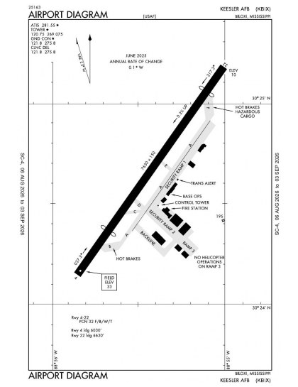
KBIX airport diagram — runways, taxiways and ramp layout
KBIX airport diagram The official FAA airport diagram — runways, taxiways, ramp layout and hold-short positions. Download PDF

7 published instrument approaches: 1 ILS approach, 2 RNAV (GPS), serving 2 runway ends.

All 9 KBIX charts in one download Every approach, departure, arrival and minimums page for this airport, sorted into folders, as a single ZIP. Taken one at a time on the free tier, 9 charts is roughly 56 sec of downloading — they queue one behind another.
PRO members only

Instrument approach procedures

ChartAmendment
ILS OR LOC RWY 22 chart previewILS OR LOC RWY 22PDF
RNAV (GPS) RWY 04 chart previewRNAV (GPS) RWY 04PDF
RNAV (GPS) RWY 22 chart previewRNAV (GPS) RWY 22PDF
TACAN RWY 04 chart previewTACAN RWY 04PDF
TACAN RWY 22 chart previewTACAN RWY 22PDF
TACAN-A chart previewTACAN-APDF
TACAN-B chart previewTACAN-BPDF

Takeoff and alternate minimums

ChartAmendment
TAKEOFF MINIMUMS chart previewTAKEOFF MINIMUMSPDF

Minimums pages cover a whole volume, so the same document is shared by every airport in it.

KBIX airport information

Control tower
Yes
Attendance
All mon-fri 1400-0500z++
ARTCC
Houston Center
Flight service
Greenwood
NOTAM facility
BIX (NOTAM-D available)
Magnetic variation
2W
Beacon
White-green (lighted land airport), sunset to sunrise
Wind indicator
Yes
Fuel
A++
Airframe service
Major
Powerplant service
Major
Bottled oxygen
None
Customs
Landing rights airport
Activated
April 1940
Ownership
Privately owned
Sectional
New Orleans

From the FAA NASR 28-day subscription, cycle 6 Aug 2026.

KBIX radio frequencies

ServiceFrequencyCall sign
Tower120.75Keesler
Ground121.8Keesler
Approach124.6130-309127.5310-129Keesler

Civil VHF frequencies from the FAA NASR 28-day subscription. Discrete sector and military frequencies are not listed.

Runways

7,630 × 150 ft0422N1,000 ft
Runway layout at KBIX, drawn to scale from FAA published runway-end coordinates and true alignments. Runways served by an ILS are highlighted.
RunwayLengthWidth SurfaceLighting
04/227,630 ft150 ftPorous asphaltHigh intensity
  04 35°TPAPI (4-box) 3° · displaced threshold 1,600 ft
  22 215°TILS · PAPI (4-box) 3° · ALSF-1 approach lighting · displaced threshold 1,000 ft · right-hand circuit

Runway and approach-aid data from the FAA NASR 28-day subscription.

Where KBIX is

Latitude, longitude30.4104270, -88.9244350
Elevation32 ft

Paste the coordinates into a simulator’s world map to drop straight onto the field.

FAA remarks for KBIX

  • OVERHEAD 1500 FT; CONVENTIONAL 1000 FT.
  • CLSD HOLS.
  • UNIT TRNG ASSEMBLY (UTA) NORMALLY FIRST WKEND OF MONTH, SAT 1700-2300Z++, SUN 1630-0500Z++. ALL NON-UTA WKENDS AFLD WILL BE CLSD BUT AVBL TO OPEN WITH PRIOR CDN; CTC AFLD MGMT OPS DSN 597-2120.
  • NON STD LEN 2000 FT.
  • LGTD WATER TWR LCTD 1775 FT RGT OF CENTERLINE RWY 04 AND 2900 FT LEFT OF CENTERLINE RWY 22.
  • CAUTION: FIRST 100 FT CONC SPHERICAL BOLLARDS LCTD 440 FT SW OF CNTLN.
  • BASH PHASE II IN EFF 1 JUN - 30 SEP; EXP HEAVIER BIRD ACT SR-SS.
  • RSTD: PPR ALL TRAN ACFT; CTC AFLD MGMT DSN 597-2120. TWY E 50 FT WID. ACFT RINSE FAC (BIRD BATH) TWY C AVBL TO C130 & LRGR. AIR CREWS CTC GND PRIOR TO ACFT ENG START. ALL C130 OR LRGR MUST FACE N ON TWY B FOR MAINT RUNS OR ENG RUN-UPS. PILOTS WILL AVOID FLYING OVR USAF MEDICAL CNTR LCTD ON BACK BAY 1 NM E OF RWY & VA HOSPITAL ON BACK BAY 1 NM W OF RWY.
  • TRAN ACFT RON MUST ARR BY 2100Z++ MON-FRI BY 2200Z++ SUN.
  • CAUTION: MARINA TREES HINDER WIND, LO WIND SPEED ON RWY 22 WHEN WIND DIR FROM 280-340. DUR AUGMENTATION/BACK UP; LTD WX OBSN TO E AND VIS MKR BYD 1 SM ONLY AVBL IN THE W TO N SECTOR, NIGHT FLOOD LGT HINDER CLOUD AND VIS OBSN, AND CEIL FRE 100-200 FT LO THAN OBSN ON RWY 22 APCH FROM NOV-MAR.
  • MISC: HNGR SPACE NOT AVBL FOR SVR WX. COMSEC MATERIALS ARE NOT AVBL.
  • JASU: 1(MA-1A); 3(A/M32-86A).
  • FLUID: SP PRESAIR LPOX LOX.
  • OIL: 0-148-156.
  • CAUTION: GS ANT 250 FT W OF CNTRLN & 1050 FT FROM AER 22.
  • MISC: RWY 04 AVBL TKOF 6632' FR KEY-HOLE; RWY 22 AVBL TKOF 6034' FR KEY-HOLE. SEE US TRML LO ARPT SKETCH FOR NSTD RWY 04/22 CONFIGURATION.
  • MISC: RWY 04 DISPL THLD DIMENSIONS AND SFC - 1ST 200 FT IS CONCRETE, NEXT 800 FT MID 75 FT IS CONCRETE OUTER WITH 37.5 FT NON-WT BRG ASPHALT EDGE EA SIDE, AND REMAINING 598 FT X 150 FT IS CONCRETE.
  • MISC: RWY 22 DISPL THLD DIMENSIONS AND SFC - 1ST 200 X 150 IS CONCRETE, NEXT 800 X 75 IS CONCRETE WITH 37.5' NON-WT BRG ASPHALT EDGE EA SIDE.
  • MISC: VIP ACFT CTC PTD 372.2 15 MIN PRIOR TO LDG WITH FIRM CHOCK TIME. DURG OPR HRS LIFEGUARD/MEDEVAC/SAR/MSN ESSENTIAL ACFT CTC AFLD MGMT. OPS DSN 597-2120, C228-377-21210, 1 HR PRIOR TO ARR FOR PROPER COORD, DUR NON-OPR HRS CTC COMD POST DSN 597-4330, C228-377-4330 1 HR PRIOR TO REQ AFLD BE OPEN.
  • MISC: CLASS D AIRSPACE EFF 1400-0500Z++ MON-FRI, 1700-2300Z++ SAT AND SUN, CLSD HOL, UNIT TRNG ASSEMBLIES 1900-0500Z++ SUN.
  • 403 WG AFRC - C130/WC130 ACFT OPR WKD.
  • CAUTION: RWY EDGE LGTS PAST THRESHOLDS GREATER THAN 10' FROM FULL STRENGTH PAVEMENT. SPOT 24/25 (TWY B AND F) LIGHT-ALLS USED WHEN C-17 PARK DURG HRS OF DARKNESS AND INCLEMENT WX.
  • CAUTION; RWY HAZ MEN OR EQUIP OPERATING RANDOMLY TO INCLUDE WITHIN 100' OF RWY DLY.
  • CAUTION: LARGE FRAME AND HEAVY ACFT WILL MAKE 180-DEGREE TURNS ON CONCRETE PORTION OF RWY.
  • HELICOPTER TFC PAT 500 FT MSL
  • PPR ALL ACFT, PPR ALL ACFT AFTER TRAN MAINT OPR CTC AFLD MGMT OPS AT DSN 597-2120.
  • RSC/RCR NOT RPT DUR PUBL AFLD CLSD TIMES.
  • SERVICE-LGT: NSTD RWY EDGE & TWY LGTS; SVRL LGTS GTR THAN 200 FT DIST APART ON RWY, SVRL MISSING TWY EXIT LGTS.
  • TRAN ALERT: TRAN MAINT OPR 1400-2300++ MON-FRI. OT WITH PRIOR COORDINATION; CTC AFLD MGMT OPS DSN 597-2120.
  • CAUTION: NVD TRNG 0200-0500Z++ TUE AND THU.
  • SVC-TRAN ALERT: NO LAV OR POTABLE WATER SVC AVBL.
  • CAUTION: BACKLINE APN: TWO SWITCHES, GREEN BOXES 5 FT SQUARE EA, LCTD WI 125 FT OF BACKLINE APN.
  • CAUTION: TWO IR LGTS OTS LCTD SW SIDE, 950 FT N OF RWY 04 THR AND NE SIDE 991 FT S OF RWY 22 THR.
  • CAUTION: RWY 04/22, TWY A, TWY D & TWY E LACK 25 FT PAVED SHOULDERS. TWY B & TWY F HAVE 25 FT PAVED SHOULDERS ONLY ON ONE SIDE.

Published verbatim from the FAA NASR subscription. Abbreviations are the FAA's own.

Approach coverage

Keesler AFB’s single 7,630 ft runway has published approaches to both ends, so instrument coverage is not confined to one direction. The seven approach charts include an ILS, a localiser procedure and two RNAV (GPS) approaches, providing both ground-based and satellite-based options. With no second runway, however, every procedure leads back to the same 04/22 alignment.

Regional chart context

Gulfport-Biloxi International has the broadest nearby procedure set, with twice Keesler’s total chart coverage. Trent Lott International and Stennis International have chart sets closer in scale to Keesler’s, while Dean Griffin Memorial and St Elmo are much more thinly covered. Beyond the instrument procedures, the New Orleans Sectional supplies wider VFR context, and the US Gulf Coast Helicopter Route Chart adds helicopter-specific routing information.

Airports near KBIX

IDAirportCity DistanceCharts
KGPTGulfport-Biloxi IntlGULFPORT, MS8 nm W18
KPQLTrent Lott IntlPASCAGOULA, MS21 nm E6
KHSAStennis IntlBAY ST LOUIS, MS28 nm W7
M24Dean Griffin MemlWIGGINS, MS29 nm NW3
2R5St ElmoST ELMO, AL34 nm E2
M13Poplarville/Pearl River CountyPOPLARVILLE, MS38 nm NW3
KMJDPicayune MuniPICAYUNE, MS38 nm W6
KMOBMobile RgnlMOBILE, AL39 nm NE12

VFR charts covering KBIX

Common questions about KBIX

What charts are available for KBIX?

9 current FAA charts for Keesler AFB, including 7 instrument approachs, 1 airport diagram. All are free to download as PDFs from this page, from the 6 August 2026 cycle.

What are the radio frequencies for KBIX?

Tower 120.75; Ground 121.8. Full civil VHF list, with sector notes, is in the frequencies table on this page — from the FAA NASR subscription.

How long is the runway at KBIX?

Keesler AFB has 1 runway. The longest is 04/22 at 7,630 ft by 150 ft, porous asphalt. Full runway dimensions, lighting and approach aids are listed on this page.

Does KBIX have an ILS approach?

Yes — 1 ILS procedure is published. In total KBIX has 7 published instrument approaches, of which 2 are RNAV (GPS).

Where can I download the KBIX airport diagram?

The official FAA airport diagram for Keesler AFB is free to download at the top of this page. It shows runways, taxiways, ramp layout and hold-short positions, and is reissued every 28 days.

Is KBIX a towered airport?

Yes. Keesler AFB has an operating control tower, within Houston Center's airspace. Tower, ground and clearance frequencies are listed on this page.

Are these KBIX charts current?

They are from the FAA cycle effective 6 August 2026, which is superseded on 3 September 2026. We publish each new cycle on its effective date. They are for flight simulation and reference only — not for real-world navigation.

Wider chart sets

Bulk archives are a PRO benefit. Individual charts are free for everyone, always.

Flying into KBIX? PRO members take all 9 charts as one ZIP instead of 9 separate downloads, at full line speed with no cap — plus every chart family archive and all 24,000+ add-ons in the library.

Go PRO

Not for navigation. For flight simulation and reference use only. Procedures are superseded on a 28-day cycle — obtain current official charts from the FAA for real-world flight.

FAA public-domain products, mirrored unmodified. Fly Away Simulation is not affiliated with or endorsed by the FAA. Chart licensing and terms.