Terminal Procedures

KNPA — Pensacola NAS (Forrest Sherman Fld)

PENSACOLA, FL · 23 FAA charts · cycle 6 Aug 2026

FAA NPAElevation 28 ft3 runwaysLongest 8,001 ftToweredVolume SE-3Not for navigation
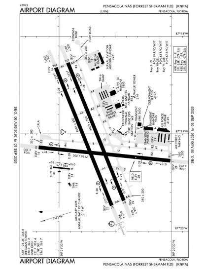
KNPA airport diagram — runways, taxiways and ramp layout
KNPA airport diagram The official FAA airport diagram — runways, taxiways, ramp layout and hold-short positions. Download PDF

20 published instrument approaches: 2 ILS approaches, 6 RNAV (GPS), 2 VOR, serving 6 runway ends.

All 23 KNPA charts in one download Every approach, departure, arrival and minimums page for this airport, sorted into folders, as a single ZIP. Taken one at a time on the free tier, 23 charts is roughly 2 min of downloading — they queue one behind another.
PRO members only

Instrument approach procedures

ChartAmendment
HI-TACAN Z RWY 01 chart previewHI-TACAN Z RWY 01PDF
HI-TACAN Z RWY 07L chart previewHI-TACAN Z RWY 07LPDF
HI-TACAN Z RWY 07R chart previewHI-TACAN Z RWY 07RPDF
HI-TACAN Z RWY 25L chart previewHI-TACAN Z RWY 25LPDF
HI-TACAN Z RWY 25R chart previewHI-TACAN Z RWY 25RPDF
HI-VOR Z RWY 19 chart previewHI-VOR Z RWY 19PDF
ILS OR RNAV (GPS) Y RWY 07L chart previewILS OR RNAV (GPS) Y RWY 07LPDF
ILS Z OR LOC Z RWY 07L chart previewILS Z OR LOC Z RWY 07LPDF
RNAV (GPS) RWY 01 chart previewRNAV (GPS) RWY 01PDF
RNAV (GPS) RWY 07R chart previewRNAV (GPS) RWY 07RPDF
RNAV (GPS) RWY 19 chart previewRNAV (GPS) RWY 19PDF
RNAV (GPS) RWY 25L chart previewRNAV (GPS) RWY 25LPDF
RNAV (GPS) RWY 25R chart previewRNAV (GPS) RWY 25RPDF
TACAN Y RWY 01 chart previewTACAN Y RWY 01PDF
TACAN Y RWY 07L chart previewTACAN Y RWY 07LPDF
TACAN Y RWY 07R chart previewTACAN Y RWY 07RPDF
TACAN Y RWY 19 chart previewTACAN Y RWY 19PDF
TACAN Y RWY 25L chart previewTACAN Y RWY 25LPDF
TACAN Y RWY 25R chart previewTACAN Y RWY 25RPDF
VOR Y RWY 19 chart previewVOR Y RWY 19PDF

Takeoff and alternate minimums

ChartAmendment
TAKEOFF MINIMUMS chart previewTAKEOFF MINIMUMSPDF
RADAR MINIMUMS chart previewRADAR MINIMUMSPDF

Minimums pages cover a whole volume, so the same document is shared by every airport in it.

KNPA airport information

Control tower
Yes
Attendance
Mar-nov mon-fri 1200-0300z
ARTCC
Jacksonville Center
Flight service
Gainesville
NOTAM facility
NPA (NOTAM-D available)
Magnetic variation
3W
Beacon
Split-white-green (military airport), sunset to sunrise
Bottled oxygen
None
Ownership
Privately owned
Sectional
New Orleans

From the FAA NASR 28-day subscription, cycle 6 Aug 2026.

KNPA radio frequencies

ServiceFrequencyCall sign
Tower120.7Sherman
Ground121.7Sherman
Clearance delivery134.1Sherman
ATIS124.35Sherman
Approach120.65Sherman

Civil VHF frequencies from the FAA NASR 28-day subscription. Discrete sector and military frequencies are not listed.

Runways

8,001 × 200 ft07L25R8,000 × 200 ft07R25L7,136 × 200 ft0119N2,000 ft
Runway layout at KNPA, drawn to scale from FAA published runway-end coordinates and true alignments. Runways served by an ILS are highlighted.
RunwayLengthWidth SurfaceLighting
07L/25R8,001 ft200 ftAsphaltHigh intensity
  07LILS/DME · PAPI (4-box) 3° · ALSF-1 approach lighting
  25RPAPI (4-box) 3°
07R/25L8,000 ft200 ftAsphaltHigh intensity
  07RPAPI (4-box) 3°
  25LPAPI (4-box) 3°
01/197,136 ft200 ftAsphaltHigh intensity
  01PAPI (4-box) 3°
  19PAPI (4-box) 3°

Runway and approach-aid data from the FAA NASR 28-day subscription.

Where KNPA is

Latitude, longitude30.3532730, -87.3179710
Elevation28 ft
From Pensacola6 nm SW

Paste the coordinates into a simulator’s world map to drop straight onto the field.

FAA remarks for KNPA

  • AVBL ONLY DURING HRS OF OPERATION.
  • FSS-GAINESVILLE GNV- NOTAM PNS
  • HOL BY NOTAM. SEE FLIP AP/1 SUPPLEMENTARY ARPT RMK.
  • A-GEAR: 15 MIN NTC FOR SHORT FIELD ARRESTMENT.
  • JASU - 2(NC-10) 2(MSU-200)
  • FUEL: JET A++
  • FLUID - SP LHOX LOX OXRB ACFT NITROGEN AND OX SVCG AVBL MAR-NOV 1200-0300Z, MON-FRI, NOV-MAR 1300-0300Z, CLSD SAT-SUN, OPEN BY NOTAM, AND HOL BY NOTAM.
  • OIL: O-128-148-156
  • TRAN SVC AVBL, CTC FOR HOURS, CLSD SAT-SUN, HOL BY NOTAM ; OT NO TRAN ACFT AUTH.
  • TFC PAT: LDG/TAXI LGT RQR ALL LDG WHEN WX COND PERMIT. WHEELS WATCH NOT ON STN. SEE MANDATORY IFR ARR PRO-FLIP AP/1 SUPPLEMENTARY ARPT RMK. REDUCED RWY SEPARATION STD IN EFF CNATRA ACFT ONLY. MULTIPLE APCH SEVERELY LTD DUR SINGLE RWY OPR.
  • NS ABTMT: REQ ALL ACFT REMAIN AT OR ABV 500' AND 0.5 NM OFF-SHORE FR NAVARRE BEACH TO W OF JOHNSON BEACH DUE TO NESTING OF PROTECTED SPECIES APR-OCT.
  • CSTMS/AG/IMG: CSTMS, AG AVBL IF PRIOR ARNG MADE WITH MIN 48 HR ADVANCE NTC.
  • CAUTION: EXPECT SIMULTANEOUS OPR DUR DUAL RY OPERATIONS. PONDING OCCURS AFTER MODERATE TO HVY RAIN AT ALL RY INT AND HOLD SHORT AREAS. RY 7L-R/25L-R GROOVED. RY 1/19 NOT GROOVED.
  • MISC- SECTOR CONTROL PENSACOLA, FL KNPA (CALL SIGN SEABREEZE) C850-452-2041, SKEDS HOURS 1200-2100Z++ MON-FRI, MAR-NOV; 1300-2200Z MON-FRI; NOV-MAR. (R) CTL SVC AND SKED PROVIDED IN W155 TO ALL MIL AND DESIGNATED CIV AIR OPR. ALL ACFT OPR IN W155 SHALL BE SKED, CHECK IN/OUT ON PRIM FREQ AND REMAIN IN CONTINUOUS RDO COM WITH SEABREEZE OR WITH THE MIL RADAR UNIT/FAC SPECIFICALLY AUTH BY SEABREEZE TO PROVIDE CTL/CONTAINMENT SVC. ACFT OPR BLW 3500- MAY NOT RECEIVE RADAR SVC DUE TO LIMITED RADAR/RADIO COVERAGE. FOR DETAILED WARNING OP AREA SKED/USE PRO, CTC SECTOR CONTROL PENSACOLA. SEABREEZE - (PRIM)-(E) (127.45 351.625) 348.0 3102.4 6835.4 H-5D, L18E, F. FLT PLANS FOR NAS PENSACOLA CAN BE SUBMITTED TO BASE OPS VIA FAX AT C850-452-8105 OR E-MAIL: CNIC_SE_PNSC_NPA_BASE_OPS@US.NAVY.MIL. TO CONFIRM RECEIPT OF FLT PLANS CTC FLT PLANNING DISPATCHER C850-452-2265/2041. KNPA ASOS DIAL-IN C850-452-3040.
  • ACFT EXP TO CONDUCT OPR FR SHERMAN FLD CTC FLEET LIAISON OFFICE DSN 459-4333, C850-452-4333 FOR SKED.
  • CIV ACFT LDG PMT CTC DEPUTY AIR OPS OFFICER DSN:459-2547 C:850-452-2547.
  • RSTD - B-52 OPS PROH. PPR REQ FOR ALL TRANSIENT AIRCRAFT. PPR VALID PLUS OR MINUS 30 MIN. OF APPRVD TIME NOT TO EXCEED BEYOND NORMAL AIRFLD CLOSURE TIME. FAILURE TO ARRIVE WITHIN THE ASSIGNED WINDOW MAY RESULT IN DENIAL OF LANDING CLEARANCE., CTC TRAN LINE DSN 850-459-2672, C850-452-2672.

Published verbatim from the FAA NASR subscription. Abbreviations are the FAA's own.

Approach coverage across all six ends

Pensacola NAS has instrument coverage to every end of its three-runway layout rather than concentrating procedures on one alignment. RNAV (GPS), VOR and localiser procedures mean the set does not depend on satellite guidance alone. Two ILS approaches provide precision coverage, but not across all six ends. All three runways exceed 7,100 ft, while the parallel 07/25 pair differs in length by only one foot, avoiding a materially shorter runway within that alignment.

Nearby and VFR coverage

Pensacola International has the broadest nearby chart set, although its 11 charts are notably fewer than KNPA’s 23; the other listed airports range from eight charts down to two. The New Orleans sectional adds broader VFR context, while the US Gulf Coast Helicopter Route Chart supplies helicopter-routing detail absent from the instrument procedures.

Airports near KNPA

IDAirportCity DistanceCharts
KPNSPensacola IntlPENSACOLA, FL10 nm NE11
KJKAGulf Shores Intl/Jack Edwards FldGULF SHORES, AL19 nm W6
5R4Holk Fld At Foley MuniFOLEY, AL20 nm W3
2R4Peter Prince FldMILTON, FL24 nm NE2
KNDZWhiting Fld NAS SouthMILTON, FL26 nm NE8
KNSEWhiting Fld NAS NorthMILTON, FL27 nm NE9
KCQFH L Sonny CallahanFAIRHOPE, AL30 nm W5
KHRTHurlburt FldMARY ESTHER, FL33 nm E7

VFR charts covering KNPA

Common questions about KNPA

What charts are available for KNPA?

23 current FAA charts for Pensacola NAS (Forrest Sherman Fld), including 20 instrument approachs, 1 airport diagram. All are free to download as PDFs from this page, from the 6 August 2026 cycle.

What are the radio frequencies for KNPA?

Tower 120.7; Ground 121.7; ATIS 124.35; Clearance delivery 134.1. Full civil VHF list, with sector notes, is in the frequencies table on this page — from the FAA NASR subscription.

How long is the runway at KNPA?

Pensacola NAS (Forrest Sherman Fld) has 3 runways. The longest is 07L/25R at 8,001 ft by 200 ft, asphalt. Full runway dimensions, lighting and approach aids are listed on this page.

Does KNPA have an ILS approach?

Yes — 2 ILS procedures are published. In total KNPA has 20 published instrument approaches, of which 6 are RNAV (GPS).

Where can I download the KNPA airport diagram?

The official FAA airport diagram for Pensacola NAS (Forrest Sherman Fld) is free to download at the top of this page. It shows runways, taxiways, ramp layout and hold-short positions, and is reissued every 28 days.

Is KNPA a towered airport?

Yes. Pensacola NAS (Forrest Sherman Fld) has an operating control tower, within Jacksonville Center's airspace. Tower, ground and clearance frequencies are listed on this page.

Are these KNPA charts current?

They are from the FAA cycle effective 6 August 2026, which is superseded on 3 September 2026. We publish each new cycle on its effective date. They are for flight simulation and reference only — not for real-world navigation.

Wider chart sets

Bulk archives are a PRO benefit. Individual charts are free for everyone, always.

Flying into KNPA? PRO members take all 23 charts as one ZIP instead of 23 separate downloads, at full line speed with no cap — plus every chart family archive and all 24,000+ add-ons in the library.

Go PRO

Not for navigation. For flight simulation and reference use only. Procedures are superseded on a 28-day cycle — obtain current official charts from the FAA for real-world flight.

FAA public-domain products, mirrored unmodified. Fly Away Simulation is not affiliated with or endorsed by the FAA. Chart licensing and terms.