Terminal Procedures

KNZY — North Island NAS (Halsey Fld)

SAN DIEGO, CA · 18 FAA charts · cycle 6 Aug 2026

FAA NZYElevation 26 ft2 runwaysLongest 8,001 ftToweredFuel 100LL avgas, JP-5Volume SW-3Not for navigation
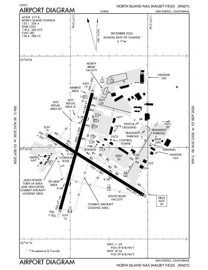
KNZY airport diagram — runways, taxiways and ramp layout
KNZY airport diagram The official FAA airport diagram — runways, taxiways, ramp layout and hold-short positions. Download PDF

11 published instrument approaches: 3 RNAV (GPS), 1 VOR, 2 localiser, serving 2 runway ends.

All 18 KNZY charts in one download Every approach, departure, arrival and minimums page for this airport, sorted into folders, as a single ZIP. Taken one at a time on the free tier, 18 charts is roughly 2 min of downloading — they queue one behind another.
PRO members only

Instrument approach procedures

ChartAmendment
HI-TACAN Z RWY 29 chart previewHI-TACAN Z RWY 29PDF
HI-TACAN Z RWY 36 chart previewHI-TACAN Z RWY 36PDF
HOTEL VISUAL RWY 29 chart previewHOTEL VISUAL RWY 29PDF
LOC/DME-A chart previewLOC/DME-APDF
LOC/DME-B chart previewLOC/DME-BPDF
RNAV (GPS) Y RWY 36 chart previewRNAV (GPS) Y RWY 36PDF
RNAV (RNP) RWY 29 chart previewRNAV (RNP) RWY 29PDF
RNAV (RNP) Z RWY 36 chart previewRNAV (RNP) Z RWY 36PDF
TACAN Y RWY 29 chart previewTACAN Y RWY 29PDF
TACAN Y RWY 36 chart previewTACAN Y RWY 36PDF
VOR/DME RWY 29 chart previewVOR/DME RWY 29PDF

Obstacle departure procedures

ChartAmendment
NASNI ONE (OBSTACLE) chart previewNASNI ONE (OBSTACLE)PDF

Arrival procedures (STAR)

ChartAmendment
BARET FIVE chart previewBARET FIVEPDF
BARET FIVE, CONT.1 chart previewBARET FIVE, CONT.1PDF
CHASR TWO (RNAV) chart previewCHASR TWO (RNAV)PDF

Takeoff and alternate minimums

ChartAmendment
TAKEOFF MINIMUMS chart previewTAKEOFF MINIMUMSPDF
RADAR MINIMUMS chart previewRADAR MINIMUMSPDF

Minimums pages cover a whole volume, so the same document is shared by every airport in it.

KNZY airport information

Control tower
Yes
Attendance
All
ARTCC
Los Angeles Center
Flight service
San Diego
NOTAM facility
NZY (NOTAM-D available)
Magnetic variation
11E
Beacon
Split-white-green (military airport), sunset to sunrise
Fuel
100LL avgas, JP-5
Bottled oxygen
None
Activated
May 1941
Ownership
Privately owned
Sectional
Los Angeles

From the FAA NASR 28-day subscription, cycle 6 Aug 2026.

KNZY radio frequencies

ServiceFrequencyCall sign
Tower135.1Navy North Island
Ground118.0Navy North Island
Clearance delivery128.4Navy North Island
Approach125.15Navy North Island
Emergency121.5Navy North Island

Civil VHF frequencies from the FAA NASR 28-day subscription. Discrete sector and military frequencies are not listed.

Runways

8,001 × 200 ft18367,501 × 200 ft1129N2,000 ft
Runway layout at KNZY, drawn to scale from FAA published runway-end coordinates and true alignments. Runways served by an ILS are highlighted.
RunwayLengthWidth SurfaceLighting
18/368,001 ft200 ftPorous asphaltHigh intensity
  18 195°TPAPI (4-box) 3°
  36 15°TPAPI (4-box) 3° · SALSF
11/297,501 ft200 ftPorous asphaltHigh intensity
  29 302°TPAPI (4-box) 3° · ALSF-1 approach lighting

Runway and approach-aid data from the FAA NASR 28-day subscription.

Where KNZY is

Latitude, longitude32.6981990, -117.2131150
Elevation26 ft
From San Diego3 nm SW

Paste the coordinates into a simulator’s world map to drop straight onto the field.

FAA remarks for KNZY

  • AVBL ONLY DURING HRS OF OPERATION.
  • 1430Z++ MON- 0600Z++ SAT; 1600Z++ SAT- 0600Z++ SUN; 1600Z++ SUN- 0600Z++ MON. CLSD 0200Z++ DAY PRIOR TO 1430Z++ DAY FOLLOWING ALL FEDERAL HOLIDAYS. SEE FLIP AP/1 SUPPLEMENTARY ARPT INFO.
  • MISC: VIP/LOGISTIC FLT CTC BASE OPS PRIOR TO LDG.
  • TFC PAT: USE MAX EXTERIOR LGT BLW 10,000' WITHIN 10 NM. ALL TRAN ACFT LTD TO FULL STOP ONLY. TOUCH-AND-GO/LO APCH NOT AVBL. TRAN ACFT SECTION APCH NOT AUTH. REDUCED RWY SEPARATION STD IN EFF USN/USMC ACFT.
  • CAUTION: EXTV VFR COPTER OPR SFC-500' VCNTY ARPT AND SFC-2000' 8 NM SE. LGT CIV ACFT CLIMB/DESCEND THRU RY 29 FINAL APCH CRS BYD 6 DME ENTER/DEP SAN DIEGO CLASS B AIRSPACE VFR CORRIDOR. AVOID CNTRLINE LGT DUR RY 29 OR RY 36 ARRESTMENT TO PREVENT TAILHOOK BOUNCE. HVY VEH TFC CROSS TWY L AND TWY A.
  • FLUID: SP PRESAIR.
  • OIL: O-128-148-156-RSTD OIL ANALYSIS AVBL, PRIOR COORD RQR.
  • TRAN ALERT: OPR 1400-0600Z WKD AND 1600-0600Z WKEND; (DT- 1300-0500Z WKD AND 1500-0500Z WKEND). NO TRAN MAINT/LTD SVC (PRKG ACFT ONLY; NO CARGO/PAX SVC). LOX NOT AVBL.
  • TRAN ALERT: TRAN AIRCREW MUST REMAIN WITH ACFT TO PROVIDE TECHNICAL DRCT/ASSISTANCE IN SVCG. AIR TRML/TRAN LINE COORD ALL REFUL REQ. ARR ACFT PASS SVC REQ TO LINEMAN. ALL TRAN PILOTS CK IN WITH ODO, BASE OPS BLDG 516, UPON ARR.
  • JASU: 2(GTC-85)(NC-8)
  • A-GEAR: SHORT-FLD A-GEAR RWY 36 NMLY DE-RIGGED. LONG-FLD A-GEAR RWY 36 NMLY DE-RIGGED. SHORT-FLD A-GEAR RWY 29 DE-RIGGED. LONG-FLD A-GEAR RWY 29 NMLY RIGGED.
  • NS ABTMT: STRICT COMPLIANCE RQR.
  • CAUTION: BIRD HAZ MAY-OCT, PARTICULARLY AT DEP END RWY 29.
  • CSTMS/AG/IMG: CSTMS AVBL WITH 2 HR NTC 1600-0100Z++ MON-SAT. MIN 4 HR NTC RQR 0100-1600Z++.
  • RADAR: SEE TERMINAL FLIP FOR RADAR MINIMA.
  • LOC: 18, 29
  • CLSD 0600-1600Z++ SAT-SUN, 0600-1430Z++ MON, CLSD 0200Z++ DAY PRIOR TO 1430Z++ DAY FLW ALL FEDERAL HOL. SEE FLIP AP/1 SUPPLEMENTARY ARPT RMK.
  • RSTD: CALL ODO BTN 1300-0500Z WKDAYS DSN 735-8233, C619-545-8233 FOR PPR. LCL FLT DRG RON PROHIBITED.
  • CAUTION: TWY DELTA AND TWY FOXTROT NOT LIT FOR NIGHT OPERATIONS.
  • CAUTION: RWY 11/29 SFC AREA BTN THE RWY EDGE LNS AND REDLS, APRXLY 50 FT ON EITHER SIDE, IS CRACKED AND HAS LOOSE GRVL. WRY 11/29 EDGE LGTS LOCATED 50 FT OUTBOARD OF RUNWAY EDGE LNS, AND ARE NOT WI 10 FT OF THE MKD RWY EDGE. PILOTS SHOULD EXERCISE CAUTION TRANSITING THE AREA BETWEEN THE RWY EDGE LNS AND REDLS.
  • CAUTION: RWY 18/36 RWY DIST MKRS LESS THAN THE REQD 50 FT OFF THE RWY EDGE.
  • CAUTION: TWY L EDGE LGTS NOT WI 10 FT OF MKD TWY EDGE.
  • FOR CD WHEN ATCT CLSD CTC SOCAL APCH AT 800-448-3724.
  • CTC AMGR 619-545-8243/619-778-2074 FOR INFO CONCERNING CIVIL ACFT LDG PMTS.
  • RSTD: MV-22, CMV-22, F-35B ACFT VTOL OPS FROM ANY RWY, TWY OR HELIPAD ARE PROHIBITED, EXC WHEN AN EMERG SITUATION DICTATES. CMV-22 VTOL OPS (FCF) AUTH ON TWY ECHO BETWEEN TWY CHARLIE AND HELIPAD 12.
  • CAUTION: DIST BTN TWY B1 CNTRLN AND TWY B2 CNTRLN IS 200 FT WHICH IS 37.5 FT SHORT OF THE RQRD 237.5 FT. NO TWY LGTS ON TWY H AND TWY D.
  • SERVICE: AIRFIELD FIREFIGHTING CAPABILITY CAT-2.
  • TSNT PILOT WITH DV CODE 6 OR HIGHER CTC BASE OPS ON 355.5 TO UPDATE ETA WHEN PRACTICAL.
  • MISC: COORD ALL DETS AND ACFT STAGING WITH THE AFM AT NBC_AIROPS_MANAGEMENT@US.NAVY.MIL.
  • TRAN ALERT: TRAN ACFT WILL HAVE SVC FOR ONE LAUNCH AND RECOVERY. FURTHER TRAN SORTIES WILL RQR SQDN MAINT PSNL TO LAUNCH AND RECOVER.
  • CAUTION: RWY 29 DIST RMNG MKRS INACCURATE. MKR 7-6500 FT RMNG (MKR 6-5500 FT, MKR 5-4500 FT, MKR 4-3650 FT, MKR 3-2800 FT, MKR 2-2000 FT, MKR 1-1000 FT).
  • TRAN ALERT: FLEET SVC AVBL DUR TRAN ALERT OPERG HRS, PN RQR; FLEET SVC RESPONSIBILITY OF AIRCREW. LAVATORY CART AVBL FOR TRAN AIRCREW USE.
  • CAUTION: TWY L CLSD, EXC AT INT OF TWY M AND ADJ TO HGR 535 TO MNVR ACFT INTO HEAVY NORTH AND VRM PRKG APN.

Published verbatim from the FAA NASR subscription. Abbreviations are the FAA's own.

Procedure coverage

North Island NAS has two runway alignments of similar length, so selecting between them does not impose a large runway-length difference. Instrument approach coverage is less evenly distributed: only two of the four runway ends are served. The published mix includes RNAV (GPS), VOR and localiser procedures, providing several forms of guidance despite that concentration.

Nearby and visual chart coverage

Among the listed nearby fields, San Diego International has the broadest procedure set, while Miramar MCAS is closest to North Island in overall chart coverage. Montgomery-Gibbs Executive and Brown Field Municipal have appreciably thinner sets, and Imperial Beach NOLF thinner still. The Los Angeles Sectional adds wider visual context, while the San Diego Terminal Area Chart provides a more detailed local terminal-area view than the instrument procedures.

Airports near KNZY

IDAirportCity DistanceCharts
KSANSan Diego IntlSAN DIEGO, CA2 nm NE29
KMYFMontgomery-Gibbs ExecSAN DIEGO, CA8 nm NE8
KNRSImperial Beach NOLF (Ream Fld)IMPERIAL BEACH, CA9 nm SE3
KNKXMiramar MCAS (Joe Foss Fld)SAN DIEGO, CA11 nm N14
KSDMBrown Fld MuniSAN DIEGO, CA14 nm SE8
KSEEGillespie FldSAN DIEGO/EL CAJON, CA14 nm NE11
KRNMRamonaRAMONA, CA25 nm NE8
KCRQMc Clellan-PalomarCARLSBAD, CA26 nm N14

VFR charts covering KNZY

Common questions about KNZY

What charts are available for KNZY?

18 current FAA charts for North Island NAS (Halsey Fld), including 11 instrument approachs, 3 arrival procedures, 1 airport diagram. All are free to download as PDFs from this page, from the 6 August 2026 cycle.

What are the radio frequencies for KNZY?

Tower 135.1; Ground 118.0; Clearance delivery 128.4. Full civil VHF list, with sector notes, is in the frequencies table on this page — from the FAA NASR subscription.

How long is the runway at KNZY?

North Island NAS (Halsey Fld) has 2 runways. The longest is 18/36 at 8,001 ft by 200 ft, porous asphalt. Full runway dimensions, lighting and approach aids are listed on this page.

Does KNZY have an ILS approach?

No ILS is published. In total KNZY has 11 published instrument approaches, of which 3 are RNAV (GPS).

Where can I download the KNZY airport diagram?

The official FAA airport diagram for North Island NAS (Halsey Fld) is free to download at the top of this page. It shows runways, taxiways, ramp layout and hold-short positions, and is reissued every 28 days.

Is KNZY a towered airport?

Yes. North Island NAS (Halsey Fld) has an operating control tower, within Los Angeles Center's airspace. Tower, ground and clearance frequencies are listed on this page.

Are these KNZY charts current?

They are from the FAA cycle effective 6 August 2026, which is superseded on 3 September 2026. We publish each new cycle on its effective date. They are for flight simulation and reference only — not for real-world navigation.

Wider chart sets

Bulk archives are a PRO benefit. Individual charts are free for everyone, always.

Flying into KNZY? PRO members take all 18 charts as one ZIP instead of 18 separate downloads, at full line speed with no cap — plus every chart family archive and all 24,000+ add-ons in the library.

Go PRO

Not for navigation. For flight simulation and reference use only. Procedures are superseded on a 28-day cycle — obtain current official charts from the FAA for real-world flight.

FAA public-domain products, mirrored unmodified. Fly Away Simulation is not affiliated with or endorsed by the FAA. Chart licensing and terms.