Terminal Procedures

KRIV — March ARB

RIVERSIDE, CA · 15 FAA charts · cycle 6 Aug 2026

FAA RIVElevation 1,536 ft2 runwaysLongest 13,302 ftToweredFuel 100LL avgas, Jet A, A++Volume SW-3Not for navigation
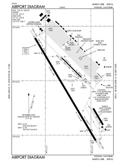
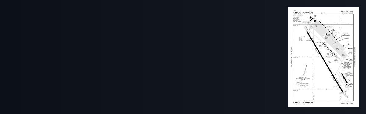
KRIV airport diagram — runways, taxiways and ramp layout
KRIV airport diagram The official FAA airport diagram — runways, taxiways, ramp layout and hold-short positions. Download PDF

10 published instrument approaches: 3 ILS approaches, 2 RNAV (GPS), 2 VOR, serving 2 runway ends.

All 15 KRIV charts in one download Every approach, departure, arrival and minimums page for this airport, sorted into folders, as a single ZIP. Taken one at a time on the free tier, 15 charts is roughly 2 min of downloading — they queue one behind another.
PRO members only

Instrument approach procedures

ChartAmendment
HI-ILS OR LOC Z RWY 32 chart previewHI-ILS OR LOC Z RWY 32PDF
HI-TACAN Z RWY 32 chart previewHI-TACAN Z RWY 32PDF
HI-VOR Z RWY 32 chart previewHI-VOR Z RWY 32PDF
ILS OR LOC X RWY 32 chart previewILS OR LOC X RWY 32PDF
ILS OR LOC Y RWY 32 chart previewILS OR LOC Y RWY 32PDF
RNAV (GPS) RWY 14 chart previewRNAV (GPS) RWY 14PDF
RNAV (GPS) RWY 32 chart previewRNAV (GPS) RWY 32PDF
TACAN Y RWY 14 chart previewTACAN Y RWY 14PDF
TACAN Y RWY 32 chart previewTACAN Y RWY 32PDF
VOR Y RWY 32 chart previewVOR Y RWY 32PDF

Departure procedures

ChartAmendment
SKYES FOUR chart previewSKYES FOURPDF

Arrival procedures (STAR)

ChartAmendment
ARKOE ONE chart previewARKOE ONEPDF
MARCH FOUR chart previewMARCH FOURPDF

Takeoff and alternate minimums

ChartAmendment
TAKEOFF MINIMUMS chart previewTAKEOFF MINIMUMSPDF

Minimums pages cover a whole volume, so the same document is shared by every airport in it.

KRIV airport information

Control tower
Yes
Attendance
All all 0700-2300
ARTCC
Los Angeles Center
Flight service
Riverside
NOTAM facility
RIV (NOTAM-D available)
Magnetic variation
14E
Beacon
White-green (lighted land airport), sunset to sunrise
Fuel
100LL avgas, Jet A, A++
Airframe service
Major
Powerplant service
Major
Bottled oxygen
High/low
Customs
Landing rights airport
Activated
May 1941
Airport area
2,075 acres
Ownership
Privately owned
Sectional
Los Angeles
Last FAA inspection
1976-09-09

From the FAA NASR 28-day subscription, cycle 6 Aug 2026.

KRIV radio frequencies

ServiceFrequencyCall sign
Tower127.65March
Ground121.75March
ATIS134.75March
Approach119.25133.5134.0March
Emergency121.5March

Civil VHF frequencies from the FAA NASR 28-day subscription. Discrete sector and military frequencies are not listed.

Runways

13,302 × 200 ft14323,061 × 100 ft1230N2,000 ft
Runway layout at KRIV, drawn to scale from FAA published runway-end coordinates and true alignments. Runways served by an ILS are highlighted.
RunwayLengthWidth SurfaceLighting
14/3213,302 ft200 ftConcrete GoodHigh intensity
  14 149°TPAPI (4-box) 2.59°
  32 329°TILS · PAPI (4-box) 3° · ALSF-1 approach lighting
12/303,061 ft100 ftAsphalt Poor

Runway and approach-aid data from the FAA NASR 28-day subscription.

Where KRIV is

Latitude, longitude33.8819430, -117.2590170
Elevation1,536 ft
From Riverside6 nm SE

Paste the coordinates into a simulator’s world map to drop straight onto the field.

FAA remarks for KRIV

  • CAUTION: NSTD RWY MRK-LANDING ZONE (LZ) MARK (3500X90 PAINTED ON RWY 32 FOR BASE ASGN C17 ACFT ONLY).
  • TFC PAT - RECTANGULAR 3000', OVERHEAD 3500'.
  • OPR H24; OPS FM 0700-1500Z++ RQR 452 OG/CC APVL, EXC FOR KRIV BASED ALERT MSN.
  • RY 12/30 CLSD TO PUBLIC-USE ONLY.
  • RWY 12/30 IS A SRY RWY, USED FOR MIL OPS AND MNTND BY THE MIL. IT IS IN VERY POOR COND.
  • CAUTION: EXTV GLIDER, SKYDIVING, BALLOONIST AND ULTRALIGHT ACT AT PERRIS ARPT, 7 NM S OF MARCH.
  • CAUTION: HEAVY MILITARY FLIGHT TRAINING.
  • JOINT USE AIRPORT - OWNED AND OPERATED BY US AIR FORCE/ NO CIVIL TOUCH AND GO OPS OR MANEUVERS.
  • AIRFIELD USE AGREEMENT WITH CIVIL ARPT AUTH (MARCH INLAND PORT ARPT AUTH) MILITARY, CIVIL COMMERCIAL AND GENERAL AVIATION(GA) USES.
  • GA OPS - PPR AND/OR LANDING PERMIT NOT REQ FOR USE OF CIVIL APRON AND RAMPS/FBO INF. -FREEMAN HOLDINGS 951-247-2111 / FREQS 130.075.
  • RY 12/30 CLSD TO PUBLIC DUE TO MUNITIONS AND EXPLOSIVES OPS IN CLOSE PROXIMITY OF RY 12/30 PER UFC & DOD REGULATIONS.
  • TRANSPORTATION LIMITED, PRIOR COORDINATION REQUIRED, CTC DSN 447-7787 WKND.
  • TSNT ACFT NO PRACTICE APCH 2100-0700.
  • GEN AVN OPS PMTD DUR FBO BUS HRS. FBO BUS HRS 1400-0600Z++ MON-FRI, OPEN SAT-SUN (IF REQ PRIOR TO CLOSE OF BUS FRI) AND WILL HONOR MEDICAL REQ MADE AT ANY TIME, CALL 951-247-2111.
  • USE EXTREME CAUTION FOR EXTV UAS OPS IN VCNTY.
  • NONSTANDARD TACAN CHECKPOINT SIGNS LCTD AT RWY A AND TWY F.
  • MIL RMK: 24 HR PN/PPR FOR ALL TRAN ACFT, CTC AFLD MGMT OPS DSN 447-4404/2422, C951-655-4404/2422.
  • MIL RMK: ALL INBD PAX/CARGO ACFT MUST CTC COMD POST DSN 447-4665 24 HR PRIOR TO ARR WITH TYPE CARGO AND NR OF PAX.
  • CSTMS/AG/IMG - CTC AFLD MGMT OPS DSN 447-4404/2422, C951-655-4404/2422 AT LEAST 24 HR PN TO ARR RQR. LTD SVC, NO RESIDENT CSTMS AGENT, BUT ON CALL H24, DRIVING FR ONTARIO INTL. NO-NTC ACFT THAT RQR CSTMS EXP MIN 2 HR DELAY. CSTMS RQR FOLLOWING FORMS FOR ARR ACFT - CBP FORM 7507 GENERAL DECLARATION, CBP FORM 6059B CUSTOMS DECLARATION FR ALL PERS ONBOARD LCTD HTTPS://WWW.CBP.GOV/NEWSROOM/PUBLICATIONS/FORMS, PAX/CARGO MANIFEST AS APPLICABLE. AIRCREW, PAX, CARGO RQR TO REMAIN IN ACFT TIL RELEASED BY CSTMS. APV LDG RIGHTS AND OVFT EXM REQ. NOT A PORT OF ENTRY, IMG SVC EXTREMELY LTD, CASE-BY-CASE BASIS. CTC PTD 2 HR PRIOR TO LDG VIA DRCT A/G COM OR FONE PATCH.
  • SERVICE - OIL: JOAP AVBL ONLY ON RESERVE WKEND. O-148.
  • RSTD: V-22 OPS RSTRD TO RWY 14/32. HELIPAD AND RWY 12/30 RSTRD TO HELS ONLY. NO FIXED WING OR V-22 ACFT PMTD DUE TO PAVEMENT RATING OF VERY POOR.
  • RSTD: TSNT RAMP PRKG SPOTS J1, K1 AND L1 RSTRD TO ACFT WITH WINGSPANS LESS THAN 185 FT.
  • RSTD: ACFT WITH WINGSPAN OF 130 FT OR GTR RSTD TO TAXI WITH OUTBOARD ENGS AT IDLE THRUST ON TWYS A AND F DUE TO SHOULDER PAVEMENT COND AND FOD POTENTIAL.
  • SERVICE - TRAN ALERT: OPR 1500-0700Z++ MON-SUN.

Published verbatim from the FAA NASR subscription. Abbreviations are the FAA's own.

Approaches concentrated on two ends

March ARB has ten approaches, but they are concentrated on only two of the four runway ends. The mix of ILS, localiser, RNAV (GPS) and VOR procedures provides several forms of instrument guidance rather than relying on a single approach type. The runway lengths are highly unequal: the shorter strip cannot provide an equivalent alignment for aircraft requiring more than 3,061 ft, leaving the 13,302 ft runway as the only option for those aircraft.

Local chart context

Riverside and San Bernardino International have chart sets close in breadth to March ARB’s, while Flabob and Redlands Municipal have much thinner coverage; Hemet-Ryan is also relatively limited. The Los Angeles Sectional supplies broader VFR context, the Terminal Area Chart adds more detailed local coverage, and the Helicopter Route Chart shows routing specific to helicopter operations.

Airports near KRIV

IDAirportCity DistanceCharts
KRIRFlabobRIVERSIDE/RUBIDOUX/, CA10 nm NW2
KRALRiversideRIVERSIDE, CA10 nm NW13
KSBDSan Bernardino IntlSAN BERNARDINO, CA13 nm N13
KREIRedlands MuniREDLANDS, CA13 nm NE2
KHMTHemet-RyanHEMET, CA15 nm SE4
KAJOCorona MuniCORONA, CA17 nm W7
F70French ValleyMURRIETA/TEMECULA, CA20 nm S2
KCNOChinoCHINO, CA20 nm W10

VFR charts covering KRIV

Common questions about KRIV

What charts are available for KRIV?

15 current FAA charts for March ARB, including 10 instrument approachs, 1 departure procedure, 2 arrival procedures, 1 airport diagram. All are free to download as PDFs from this page, from the 6 August 2026 cycle.

What are the radio frequencies for KRIV?

Tower 127.65; Ground 121.75; ATIS 134.75. Full civil VHF list, with sector notes, is in the frequencies table on this page — from the FAA NASR subscription.

How long is the runway at KRIV?

March ARB has 2 runways. The longest is 14/32 at 13,302 ft by 200 ft, concrete. Full runway dimensions, lighting and approach aids are listed on this page.

Does KRIV have an ILS approach?

Yes — 3 ILS procedures are published. In total KRIV has 10 published instrument approaches, of which 2 are RNAV (GPS).

Where can I download the KRIV airport diagram?

The official FAA airport diagram for March ARB is free to download at the top of this page. It shows runways, taxiways, ramp layout and hold-short positions, and is reissued every 28 days.

Is KRIV a towered airport?

Yes. March ARB has an operating control tower, within Los Angeles Center's airspace. Tower, ground and clearance frequencies are listed on this page.

Are these KRIV charts current?

They are from the FAA cycle effective 6 August 2026, which is superseded on 3 September 2026. We publish each new cycle on its effective date. They are for flight simulation and reference only — not for real-world navigation.

Wider chart sets

Bulk archives are a PRO benefit. Individual charts are free for everyone, always.

Flying into KRIV? PRO members take all 15 charts as one ZIP instead of 15 separate downloads, at full line speed with no cap — plus every chart family archive and all 24,000+ add-ons in the library.

Go PRO

Not for navigation. For flight simulation and reference use only. Procedures are superseded on a 28-day cycle — obtain current official charts from the FAA for real-world flight.

FAA public-domain products, mirrored unmodified. Fly Away Simulation is not affiliated with or endorsed by the FAA. Chart licensing and terms.