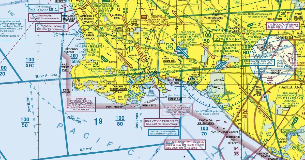
Official FAA digital chart — free GeoTIFF and PDF download
| Format | What you get | Size | |
|---|---|---|---|
| GeoTIFF | Georeferenced raster at 300 dpi, with world file and FGDC metadata | 35.7 MB | Download |
| Print-ready chart, no georeferencing | 69.8 MB | Download |
Not for navigation. For flight simulation and reference use only. Check the effective dates above, and obtain official charts from the FAA for real-world flight.

These are big files. This chart alone is 69.8 MB. Guest downloads are rate limited; PRO members get full-speed, unthrottled downloads across every chart and all 24,000+ add-ons in the library.
Go PROGreater Los Angeles sits at the centre of a sheet stretching from the Ventura coast and Pacific waters eastwards across the Los Angeles Basin, the Inland Empire and the Coachella Valley into the Southern California desert. Catalina Island lies within its coastal coverage, while the northern edge takes in the abrupt mountain country separating the basin from the Mojave Desert.
This compact east–west span brings together markedly different flying environments: a broad, heavily developed coastal basin, rugged ridges and passes, inland valleys, and open desert. The San Diego Terminal Area Chart adjoins to the south-east, providing continuity for routes extending towards that region.
The Terminal Area Chart provides the closer-scale view suited to the concentrated Los Angeles region. The corresponding Sectional Aeronautical Chart places the same area within a broader Southern California context, making it more useful for routes continuing well beyond the terminal region. The Helicopter Route Chart serves a more specialised purpose, presenting the area for rotorcraft operations and route planning at an appropriate local scale.
| ID | Airport | City | Elev | Rwys | Longest |
|---|---|---|---|---|---|
| KRIV RIV | March ARB | RIVERSIDE, CA | 1,536 ft | 2 | 13,302 ft |
| KLAX LAX | Los Angeles Intl | LOS ANGELES, CA | 127 ft | 4 | 12,923 ft |
| KONT ONT | Ontario Intl | ONTARIO, CA | 944 ft | 2 | 12,197 ft |
| KLGB LGB | Long Beach (Daugherty Fld) | LONG BEACH, CA | 60 ft | 7 | 10,000 ft |
| KPSP PSP | Palm Springs Intl | PALM SPRINGS, CA | 476 ft | 2 | 10,000 ft |
| KSBD SBD | San Bernardino Intl | SAN BERNARDINO, CA | 1,159 ft | 1 | 10,000 ft |
| KTRM TRM | Jacqueline Cochran Rgnl | PALM SPRINGS, CA | -114 ft | 2 | 8,500 ft |
| KVNY VNY | Van Nuys | VAN NUYS, CA | 802 ft | 2 | 8,001 ft |
| KCNO CNO | Chino | CHINO, CA | 650 ft | 3 | 7,000 ft |
| KBUR BUR | Hollywood Burbank | BURBANK, CA | 778 ft | 2 | 6,886 ft |
| KCMA CMA | Camarillo | CAMARILLO, CA | 76 ft | 3 | 6,013 ft |
| F70 | French Valley | MURRIETA/TEMECULA, CA | 1,349 ft | 1 | 6,000 ft |
| KOXR OXR | Oxnard | OXNARD, CA | 44 ft | 1 | 5,953 ft |
| L35 | Big Bear City | BIG BEAR CITY, CA | 6,752 ft | 1 | 5,850 ft |
| KSNA SNA | John Wayne/Orange County | SANTA ANA, CA | 55 ft | 3 | 5,700 ft |
| KTNP TNP | Twentynine Palms | TWENTYNINE PALMS, CA | 1,888 ft | 2 | 5,531 ft |
| KRAL RAL | Riverside | RIVERSIDE, CA | 818 ft | 3 | 5,401 ft |
| L65 | Perris Valley | PERRIS, CA | 1,413 ft | 1 | 5,100 ft |
| KUDD UDD | Bermuda Dunes | PALM SPRINGS, CA | 73 ft | 1 | 5,002 ft |
| KTOA TOA | Zamperini Fld | TORRANCE, CA | 103 ft | 3 | 5,001 ft |
| KBNG BNG | Banning Muni | BANNING, CA | 2,222 ft | 1 | 4,955 ft |
| KHHR HHR | Jack Northrop Fld/Hawthorne Muni | HAWTHORNE, CA | 65 ft | 1 | 4,884 ft |
| KPOC POC | Brackett Fld | LA VERNE, CA | 1,013 ft | 2 | 4,840 ft |
| KREI REI | Redlands Muni | REDLANDS, CA | 1,574 ft | 1 | 4,504 ft |
| L22 | Yucca Valley | YUCCA VALLEY, CA | 3,224 ft | 1 | 4,363 ft |
| KHMT HMT | Hemet-Ryan | HEMET, CA | 1,514 ft | 2 | 4,315 ft |
| L70 | Agua Dulce | AGUA DULCE, CA | 2,633 ft | 1 | 4,205 ft |
| KWHP WHP | Whiteman | LOS ANGELES, CA | 1,003 ft | 1 | 4,120 ft |
| L77 | Chiriaco Summit | CHIRIACO SUMMIT, CA | 1,710 ft | 1 | 4,000 ft |
| KEMT EMT | San Gabriel Valley | EL MONTE, CA | 295 ft | 1 | 3,995 ft |
| L26 | Hesperia | HESPERIA, CA | 3,390 ft | 1 | 3,910 ft |
| KCCB CCB | Cable | UPLAND, CA | 1,443 ft | 3 | 3,863 ft |
| KSMO SMO | Santa Monica Muni | SANTA MONICA, CA | 169 ft | 2 | 3,500 ft |
| KCPM CPM | Compton/Woodley | COMPTON, CA | 98 ft | 2 | 3,323 ft |
| KAJO AJO | Corona Muni | CORONA, CA | 533 ft | 1 | 3,200 ft |
| KRIR RIR | Flabob | RIVERSIDE/RUBIDOUX/, CA | 767 ft | 1 | 3,190 ft |
| KFUL FUL | Fullerton Muni | FULLERTON, CA | 96 ft | 4 | 3,121 ft |
| KAVX AVX | Catalina | AVALON, CA | 1,602 ft | 1 | 3,000 ft |
| KSZP SZP | Santa Paula | SANTA PAULA, CA | 250 ft | 2 | 2,665 ft |
39 public-use airports within this chart's coverage, ordered by runway length. A further 20 private and restricted landing facilities are not listed. Source: FAA NASR 28-day subscription.
Approach plates and airport diagrams for every airport in the states this sheet covers:
It spans 33.4°N to 34.5°N and 119.5°W to 115.7°W. Airports on the sheet fall within California. The full list of public-use airports within its coverage is on this page.
Take the GeoTIFF if you are loading the chart into moving-map software or a flight planner — it is georeferenced, so the software can place it correctly on a map, and it ships with a world file and FGDC metadata at 300 dpi (35.7 MB). Take the PDF to print it or read it on a second screen (69.8 MB); it is the same chart without georeferencing.
This is the FAA edition effective 3 September 2026, which is superseded on 29 October 2026. Visual charts are reissued every 56 days and we publish each new edition on the day it takes effect. It is for flight simulation and reference only — not for real-world navigation.
San Diego to the south-east. Each is linked from this page, so a route running off one edge can be continued on the next sheet.
Yes, with no account required. FAA charts are United States Government works and are not subject to copyright protection in the US under 17 U.S.C. § 105. Guest downloads are speed-capped, so a sheet this size takes a while; PRO members download at full line speed and can take the whole family as one archive.

FAA public-domain products, mirrored unmodified. Fly Away Simulation is not affiliated with or endorsed by the FAA. Chart licensing and terms.

