LOS ANGELES, CA · 103 FAA charts · cycle 1 Oct 2026
26 published instrument approaches: 10 ILS approaches including CAT II/III minima, 16 RNAV (GPS), serving 8 runway ends.
| Chart | Amendment | ||
|---|---|---|---|
| TAKEOFF MINIMUMS | — |
Minimums pages cover a whole volume, so the same document is shared by every airport in it.
| Chart | Amendment | ||
|---|---|---|---|
| HOT SPOT | — |
From the FAA NASR 28-day subscription, cycle 1 Oct 2026.
| Service | Frequency | Call sign |
|---|---|---|
| UNICOM | 122.95 | |
| Tower | 119.8Helicopters120.95South Cmplx133.9North Cmplx | Los Angeles |
| Ground | 121.4West121.65North-Cmplx121.75South Cmplx | Los Angeles |
| Clearance delivery | 120.35 | Los Angeles |
| ATIS | 133.8Arr135.65Dep | Los Angeles |
| Approach | 124.3Apch Fm West/Dep To West124.5225-044 Lax124.9090-224 Lax128.5045-089 Lax | Los Angeles |
| Departure | 125.2225-044 Lax | Los Angeles |
| Emergency | 121.5 | Los Angeles |
Civil VHF frequencies from the FAA NASR 28-day subscription. Discrete sector and military frequencies are not listed.
| Runway | Length | Width | Surface | Lighting |
|---|---|---|---|---|
| 07L/25R | 12,923 ft | 150 ft | Concrete Good | High intensity |
| 07L 83°T | ILS/DME · PAPI (4-box) 3° · MALSR approach lighting · displaced threshold 832 ft · right-hand circuit | |||
| 25R 263°T | ILS/DME · PAPI (4-box) 3° · MALSR approach lighting · displaced threshold 957 ft | |||
| 07R/25L | 11,095 ft | 200 ft | Asphalt over concrete Good | High intensity |
| 07R 83°T | ILS/DME · PAPI (4-box) 3° · MALSR approach lighting · right-hand circuit | |||
| 25L 263°T | ILS/DME · PAPI (4-box) 3° · ALSF-2 approach lighting | |||
| 06R/24L | 10,885 ft | 150 ft | Concrete Good | High intensity |
| 06R 83°T | ILS/DME · PAPI (4-box) 3° · MALSR approach lighting · displaced threshold 537 ft | |||
| 24L 263°T | ILS/DME · PAPI (4-box) 3° · MALSR approach lighting · displaced threshold 801 ft · right-hand circuit | |||
| 06L/24R | 8,926 ft | 150 ft | Asphalt over concrete Good | High intensity |
| 06L 83°T | ILS/DME · PAPI (4-box) 3° · MALSR approach lighting | |||
| 24R 263°T | ILS/DME · PAPI (4-box) 3° · ALSF-2 approach lighting · right-hand circuit | |||
Runway and approach-aid data from the FAA NASR 28-day subscription.
33.9424960, -118.4080490
127 ft9 nm SWPaste the coordinates into a simulator’s world map to drop straight onto the field.
Published verbatim from the FAA NASR subscription. Abbreviations are the FAA's own.
All eight runway ends have published approaches, so the procedure set covers both directions on all four runways rather than concentrating instrument access on one alignment. ILS, localiser and RNAV (GPS) procedures provide several forms of guidance, with CAT II/III minima published for two ILS approaches. Every runway exceeds 8,900 ft and three exceed 10,800 ft, giving the field multiple long-runway options within its paired parallel layout.
Among nearby fields, Long Beach and Bob Hope have the broadest chart sets, with Santa Monica also relatively well covered. Hawthorne and Zamperini Field have markedly thinner procedure collections. The Los Angeles Sectional supplies wider-area VFR context, while the Terminal Area Chart adds a more detailed view of the immediate Los Angeles area beyond the airport-specific instrument procedures.
| ID | Airport | City | Distance | Charts |
|---|---|---|---|---|
| KHHR | Jack Northrop Fld/Hawthorne Muni | HAWTHORNE, CA | 4 nm E | 15 |
| KSMO | Santa Monica Muni | SANTA MONICA, CA | 5 nm NW | 24 |
| KTOA | Zamperini Fld | TORRANCE, CA | 9 nm S | 12 |
| KLGB | Long Beach (Daugherty Fld) | LONG BEACH, CA | 15 nm SE | 31 |
| KBUR | Hollywood Burbank | BURBANK, CA | 16 nm N | 27 |
| KVNY | Van Nuys | VAN NUYS, CA | 17 nm N | 28 |
| KWHP | Whiteman | LOS ANGELES, CA | 19 nm N | 6 |
| KSLI | Los Alamitos AAF | LOS ALAMITOS, CA | 20 nm SE | 10 |
103 current FAA charts for Los Angeles Intl, including 26 instrument approachs, 40 departure procedures, 34 arrival procedures, 1 airport diagram. All are free to download as PDFs from this page, from the 1 October 2026 cycle.
Tower 119.8, 120.95, 133.9; Ground 121.4, 121.65, 121.75; ATIS 133.8, 135.65; UNICOM 122.95; Clearance delivery 120.35. Full civil VHF list, with sector notes, is in the frequencies table on this page — from the FAA NASR subscription.
Los Angeles Intl has 4 runways. The longest is 07L/25R at 12,923 ft by 150 ft, concrete. Full runway dimensions, lighting and approach aids are listed on this page.
Yes — 10 ILS procedures are published, including CAT II/III minima. In total KLAX has 26 published instrument approaches, of which 16 are RNAV (GPS).
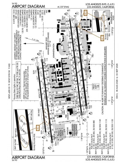
The official FAA airport diagram for Los Angeles Intl is free to download at the top of this page. It shows runways, taxiways, ramp layout and hold-short positions, and is reissued every 28 days.
Yes. 2 of the published ILS procedures carry CAT II/III minima, which allow approaches in lower visibility than a standard CAT I ILS. Those plates are listed separately in the approach table above, marked CAT II or CAT III in the chart name.
Yes. Los Angeles Intl has an operating control tower, within Los Angeles Center's airspace. Tower, ground and clearance frequencies are listed on this page.
4, which is why the chart set is as large as it is — each runway end that supports an instrument approach needs its own plates. The runway diagram on this page shows the layout to scale.
They are from the FAA cycle effective 1 October 2026, which is superseded on 29 October 2026. We publish each new cycle on its effective date. They are for flight simulation and reference only — not for real-world navigation.

Flying into KLAX? PRO members take all 103 charts as one ZIP instead of 103 separate downloads, at full line speed with no cap — plus every chart family archive and all 24,000+ add-ons in the library.
Go PRO
Not for navigation. For flight simulation and reference use only. Procedures are superseded on a 28-day cycle — obtain current official charts from the FAA for real-world flight.
FAA public-domain products, mirrored unmodified. Fly Away Simulation is not affiliated with or endorsed by the FAA. Chart licensing and terms.

