Terminal Procedures

KNGP — Corpus Christi NAS (Truax Fld)

CORPUS CHRISTI, TX · 21 FAA charts · cycle 6 Aug 2026

FAA NGPElevation 18 ft4 runwaysLongest 8,001 ftToweredVolume SC-3Not for navigation
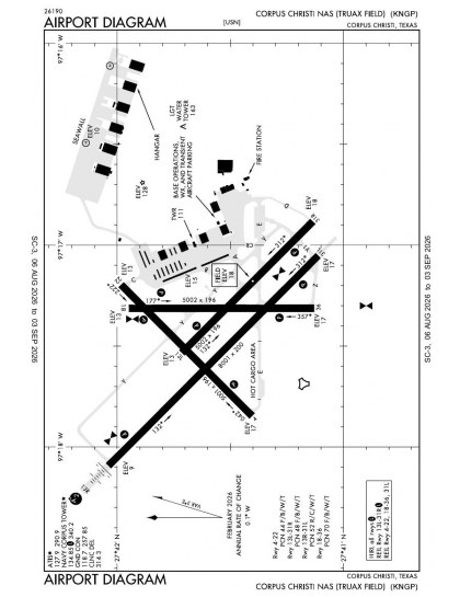
KNGP airport diagram — runways, taxiways and ramp layout
KNGP airport diagram The official FAA airport diagram — runways, taxiways, ramp layout and hold-short positions. Download PDF

18 published instrument approaches: 2 ILS approaches, 8 RNAV (GPS), 2 VOR, serving 8 runway ends.

All 21 KNGP charts in one download Every approach, departure, arrival and minimums page for this airport, sorted into folders, as a single ZIP. Taken one at a time on the free tier, 21 charts is roughly 2 min of downloading — they queue one behind another.
PRO members only

Instrument approach procedures

ChartAmendment
HI-TACAN W RWY 31L chart previewHI-TACAN W RWY 31LPDF
HI-TACAN X RWY 13R chart previewHI-TACAN X RWY 13RPDF
ILS Y OR RNAV (GPS) RWY 13R chart previewILS Y OR RNAV (GPS) RWY 13RPDF
ILS Z OR LOC Z RWY 13R chart previewILS Z OR LOC Z RWY 13RPDF
RNAV (GPS) RWY 04 chart previewRNAV (GPS) RWY 04PDF
RNAV (GPS) RWY 13L chart previewRNAV (GPS) RWY 13LPDF
RNAV (GPS) RWY 18 chart previewRNAV (GPS) RWY 18PDF
RNAV (GPS) RWY 22 chart previewRNAV (GPS) RWY 22PDF
RNAV (GPS) RWY 31L chart previewRNAV (GPS) RWY 31LPDF
RNAV (GPS) RWY 31R chart previewRNAV (GPS) RWY 31RPDF
RNAV (GPS) RWY 36 chart previewRNAV (GPS) RWY 36PDF
TACAN RWY 18 chart previewTACAN RWY 18PDF
TACAN RWY 36 chart previewTACAN RWY 36PDF
TACAN X RWY 31L chart previewTACAN X RWY 31LPDF
TACAN Z RWY 13R chart previewTACAN Z RWY 13RPDF
TACAN Z RWY 31L chart previewTACAN Z RWY 31LPDF
VOR/DME OR TACAN Y RWY 13R chart previewVOR/DME OR TACAN Y RWY 13RPDF
VOR/DME OR TACAN Y RWY 31L chart previewVOR/DME OR TACAN Y RWY 31LPDF

Takeoff and alternate minimums

ChartAmendment
TAKEOFF MINIMUMS chart previewTAKEOFF MINIMUMSPDF
RADAR MINIMUMS chart previewRADAR MINIMUMSPDF

Minimums pages cover a whole volume, so the same document is shared by every airport in it.

KNGP airport information

Control tower
Yes
Attendance
All mon-thu 1300-0500z++
ARTCC
Houston Center
Flight service
San Angelo
NOTAM facility
NGP (NOTAM-D available)
Magnetic variation
3E
Beacon
Split-white-green (military airport), sunset to sunrise
Bottled oxygen
High/low
Activated
July 1943
Ownership
Privately owned
Sectional
Brownsville

From the FAA NASR 28-day subscription, cycle 6 Aug 2026.

KNGP radio frequencies

ServiceFrequencyCall sign
CTAF134.85
Tower125.525SouthNavy Corpus
Ground118.7Navy Corpus
ATIS127.9Navy Corpus
Approach120.9All Rwy Except As Noted, Hi-Tacan Rwy 13r127.5Hi-Tacan Rwy 31l128.675Navy Corpus
Emergency121.5Navy Corpus

Civil VHF frequencies from the FAA NASR 28-day subscription. Discrete sector and military frequencies are not listed.

Runways

8,001 × 200 ft13R31L5,002 × 220 ft13L31R5,002 × 196 ft18365,001 × 200 ft0422N2,000 ft
Runway layout at KNGP, drawn to scale from FAA published runway-end coordinates and true alignments. Runways served by an ILS are highlighted.
RunwayLengthWidth SurfaceLighting
13R/31L8,001 ft200 ftPorous asphaltHigh intensity
  13R 134°TILS/DME · PAPI (4-box) 3° · SALSF · right-hand circuit
  31L 314°TPAPI (4-box) 3°
13L/31R5,002 ft220 ftAsphaltHigh intensity
  13L 134°TPAPI (4-box) 3°
  31R 314°TPAPI (4-box) 3° · right-hand circuit
18/365,002 ft196 ftAsphaltHigh intensity
  18 179°TPAPI (4-box) 3° · right-hand circuit
  36 359°TPAPI (4-box) 3°
04/225,001 ft200 ftAsphaltHigh intensity
  04 45°TPAPI (4-box) 3°
  22 225°TPAPI (4-box) 3° · right-hand circuit

Runway and approach-aid data from the FAA NASR 28-day subscription.

Where KNGP is

Latitude, longitude27.6927010, -97.2903790
Elevation18 ft
From Corpus Christi6 nm SE

Paste the coordinates into a simulator’s world map to drop straight onto the field.

FAA remarks for KNGP

  • DUSK-DAWN. WHEN TWR CLSD ACTVT PCL - CTAF.
  • CLSD SAT, SUN & HOL. (DT 1200-0400Z MON-THU; 1200-2400Z FRI; CLSD SAT, SUN & HOL); OT CK NOTAM.
  • /2506.
  • CLSD SUN 1400-1800Z++
  • CAUTION: HI MID-AIR POTENTIAL, EXTREME VIGILANCE RQR. EXER EXTREME CAUTION VCNTY WALDRON FLD NALF LCTD 3 NM S.
  • CAUTION: NMRS BIRDS VCNTY AFLD, USE EXTREME CTN DURG HVY RAIN EVENTS.
  • TFC PAT: ALL ACFT USE LDG OR TAXI LGT WHILE IN ARPT TFC AREA.
  • SERVICE-TRAN ALERT: TRAN ACFT EXP DELAYS FROM 0900-1400L DUE TO LTD REFUL/SVC. MAINT EXTREMELY LTD BEFORE 0900L, AFTER 1400L AND DURING NON-WORK HRS.
  • A: ALL R/W AND F/W ACFT LDG/TAXIING TO SEAWALL PPR DSN 861-2506/2507 C361-961-2506/2507.
  • A: AVOID FLT OVER POPULATED AREAS BLW 1000' AGL PRIOR TO GULF SHORE LINE.
  • TFC PAT: TRAN ACFT EXP APCH TO FULL STOP LDG ONLY WHEN SINGLE RWY OPR ARE BEING CONDUCTED, PRACTICE APCH NOT AUTH.
  • BEARING STRENGTH RWY 13L/31R: ST175 SBTT542 TRT585.
  • JASU: 3(MSU-200, A/UA47A-5), MEPP- 2(NC-8), 3(NC-10), 2(AM32A-108).
  • FUEL: F-24.
  • FLUID: SP PRESAIR LOX LHOXRB.
  • OIL: MIL-PRF-23699 (NATO: 0-156) AND MIL-PRF-7808 L GRADE 3 (NATO: 0-148).
  • CAUTION: EXTV R/W TEST FLTS CONDUCTED MON-SAT FM TOWN OF PORT O'CONNOR TO MUSTANG BEACH ARPT (KRAS), ALG THE COAST FM 300 - 5000 FT.
  • RSTD: REFUEL/TRAN ALERT ARNG STRONGLY RECOMMENDED FOR ALL ACFT TO AVOID EXTV SVCG/TURNAROUND DELAYS OR PRK IN HI FOD RISK AREAS.
  • CSTMS/AG/IMG CSTMS, IMG AVBL FOR ACFT ARRIVING FROM OVERSEAS, PLAN ARR FROM BTN 1400-2100Z-, C361-961-2506/2507.. PILOTS RQR TO PROVIDE IDENTA-PLATE NR TO INSPECTOR FOR BILLING.
  • A: R/W ACFT DESTINED FOR CORPUS CHRISTI ARMY DEPOT TURN IN WILL REMAIN AT LEAST 1/4 NM OFF SHORE AND 500' PRIOR TO CTC NAVY CORPUS TWR. PPR ALL CCAD TRAN ACFT. TURN IN WILL ONLY BE ACCEPTED DUR NML DUTY HR, 1300-2300Z++ MON-FRI. MON-FRI.
  • A: R/W ACFT MAKE APCH TO HELIPAD ADJ HNGR 44, CTC OPS/ X-RAY CHARLIE AND GND TAXI TO/FROM PARKING. POC AVN DIV, HNGR 44.
  • A: AVOID OVFT OF BLDG S OF RAMP AREA AND AMMO DUMP E OF CONTAINMENT AREA.
  • A: ALL ACFT WITH WEAPONS ARR CCAD AFTER NML DUTY HR NOTIFY CCAD SECURITY DSN 861-3313/3314, C361-961-3313/3314.
  • A: MAJ MAINT AVBL.
  • A: LOADING/UNLOADING OF AIR CARGO - MIL/CIV DESIGNATED FOR CCAD WILL BE SCHED FOR DAYLGT HR ONLY.
  • CAUTION: BIRD ACTIVITY/BASH - SEE AP-1.
  • CAUTION: IF EQUIPPED, ALL ACFT SHALL UTILIZE UHF ATC FREQS UNLESS ASSIGNED VHF.
  • MISC: CLSD TWR OPS: DEPARTING IFR ACFT SHALL OBTAIN AN IFR CLNC AND RELEASE FROM SAN ANGELO FSS PRIOR TO TKOF WHEN THE FIELD IS IFR VIA GROUND LINK OR CORPUS CHRISTI APCH BY CALLING 361-299-4230. IF THE FIELD IS VFR, A VFR DEPARTURE IS AUTHORIZED.
  • RSTD: ACFT ARR/DEP PROHIBITED ONE HR PRIOR TO AFLD OPENING DUE TO AFLD PREPARATIONS EXC FOR CUST/BORDER PROTECTION. MSN CRITICAL OR OTR EVENT RQR CTC AFM C361-961-2506/2507/5511.
  • MISC: ACFT OPERATING TO THE SEA WALL USE CAUTION. INBD HELI CTC CORPUS CHRISTI ARMY DEPOT (CCAD) FLT OPS X-RAY CHARLIE AT 49.70, 139.0, 339.7, OR DSN 861-0520/1020, C361-961-0520/1020.
  • RSTD: PPR 48 HR ALL TRAN ACFT, DSN 861-2506/2507, C361-961-2506/2507. FOR CIV AIR LDG PMT INFO CTC AFM C361-961-2506/5511.
  • RMK: AFM HR 1230-0500Z++ MON-THU; 1230-0100Z++ FRI; CLSD SAT, SUN AND HOL.
  • TWY Y OPEN FM INTXN OF RWY 04/22 TO APCH END RWY 13R.
  • SERVICE - FLUID - LO) AVBL ONLY WITH 7 DAYS PN OF RQMNT.
  • MAIN PRKG APRON FM TWY A TO TWY C LTD TO TW4 ACFT ONLY.
  • SERVICE: NO LAVATORY SVCS AVBL HERE.
  • RSTD: RWY 31L LEAD OFF CNTRLN MRKGS AT TWY ECHO RIGHT SIDE REMOVED.

Published verbatim from the FAA NASR subscription. Abbreviations are the FAA's own.

Approach coverage across the whole layout

Corpus Christi NAS has published instrument approaches to all eight runway ends, so coverage is spread across the complete four-runway layout rather than concentrated on one alignment. The mix is led by RNAV (GPS), with ILS, VOR and localiser procedures adding distinct forms of guidance. Runway 13R/31L is about 3,000 ft longer than each of the other three runways, making it the clear outlier where available runway length is the main distinction.

Regional chart context

Corpus Christi Intl has the only nearby procedure set approaching this field’s breadth, with 15 charts against 21. Mustang Beach, Ingleside Regional, Nueces County and Sinton each have only four or five, so their published coverage is markedly thinner. Three sectional charts provide overlapping VFR context, while the US Gulf Coast Helicopter Route Chart adds helicopter-route detail absent from the instrument procedure set.

Airports near KNGP

IDAirportCity DistanceCharts
KCRPCorpus Christi IntlCORPUS CHRISTI, TX12 nm NW15
KRASMustang BeachPORT ARANSAS, TX13 nm NE4
KTFPIngleside RgnlINGLESIDE, TX14 nm N5
KRBONueces CountyROBSTOWN, TX22 nm W4
T69SintonSINTON, TX25 nm NW5
KRKPAransas CountyROCKPORT, TX27 nm NE7
KNQIKingsville NASKINGSVILLE, TX30 nm W17
KALIAlice IntlALICE, TX39 nm W5

VFR charts covering KNGP

Common questions about KNGP

What charts are available for KNGP?

21 current FAA charts for Corpus Christi NAS (Truax Fld), including 18 instrument approachs, 1 airport diagram. All are free to download as PDFs from this page, from the 6 August 2026 cycle.

What are the radio frequencies for KNGP?

Tower 125.525; Ground 118.7; ATIS 127.9; CTAF 134.85. Full civil VHF list, with sector notes, is in the frequencies table on this page — from the FAA NASR subscription.

How long is the runway at KNGP?

Corpus Christi NAS (Truax Fld) has 4 runways. The longest is 13R/31L at 8,001 ft by 200 ft, porous asphalt. Full runway dimensions, lighting and approach aids are listed on this page.

Does KNGP have an ILS approach?

Yes — 2 ILS procedures are published. In total KNGP has 18 published instrument approaches, of which 8 are RNAV (GPS).

Where can I download the KNGP airport diagram?

The official FAA airport diagram for Corpus Christi NAS (Truax Fld) is free to download at the top of this page. It shows runways, taxiways, ramp layout and hold-short positions, and is reissued every 28 days.

Is KNGP a towered airport?

Yes. Corpus Christi NAS (Truax Fld) has an operating control tower, within Houston Center's airspace. Tower, ground and clearance frequencies are listed on this page.

How many runways does KNGP have?

4, which is why the chart set is as large as it is — each runway end that supports an instrument approach needs its own plates. The runway diagram on this page shows the layout to scale.

Are these KNGP charts current?

They are from the FAA cycle effective 6 August 2026, which is superseded on 3 September 2026. We publish each new cycle on its effective date. They are for flight simulation and reference only — not for real-world navigation.

Wider chart sets

Bulk archives are a PRO benefit. Individual charts are free for everyone, always.

Flying into KNGP? PRO members take all 21 charts as one ZIP instead of 21 separate downloads, at full line speed with no cap — plus every chart family archive and all 24,000+ add-ons in the library.

Go PRO

Not for navigation. For flight simulation and reference use only. Procedures are superseded on a 28-day cycle — obtain current official charts from the FAA for real-world flight.

FAA public-domain products, mirrored unmodified. Fly Away Simulation is not affiliated with or endorsed by the FAA. Chart licensing and terms.