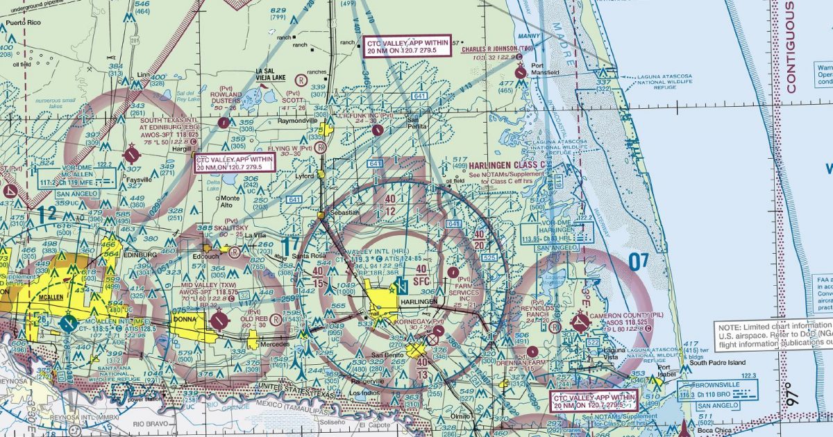
Official FAA digital chart — free GeoTIFF and PDF download
| Format | What you get | Size | |
|---|---|---|---|
| GeoTIFF | Georeferenced raster at 300 dpi, with world file and FGDC metadata | 51.3 MB | Download |
| Print-ready chart, no georeferencing | 108.4 MB | Download |
Not for navigation. For flight simulation and reference use only. Check the effective dates above, and obtain official charts from the FAA for real-world flight.

These are big files. This chart alone is 108.4 MB. Guest downloads are rate limited; PRO members get full-speed, unthrottled downloads across every chart and all 24,000+ add-ons in the library.
Go PROThe Lower Rio Grande Valley anchors the eastern side of a sheet extending from the Corpus Christi area deep into northern Mexico. It follows the western Gulf coast south through Tamaulipas towards Ciudad Victoria, while the broad western reach takes in Monterrey, Saltillo and the high interior beyond.
The flying landscape changes markedly across the coverage. Gulf waters, coastal lagoons and low coastal plains dominate the east. Inland, the ground rises towards the Sierra Madre Oriental, with ridges, valleys and increasingly dry plateau country replacing the flatter coastal terrain. The Rio Grande provides the major geographical divide across the northern part of the sheet.
The chart meets San Antonio to the north, Houston to the north-east and El Paso to the north-west. Together, those joins support routes continuing along the Texas coast, north into central Texas or west across the interior borderlands without making the Brownsville sheet stand alone.
| ID | Airport | City | Elev | Rwys | Longest |
|---|---|---|---|---|---|
| KHRL HRL | Valley Intl | HARLINGEN, TX | 36 ft | 3 | 9,400 ft |
| KLRD LRD | Laredo Intl | LAREDO, TX | 508 ft | 3 | 8,743 ft |
| KPIL PIL | Cameron County | PORT ISABEL, TX | 18 ft | 4 | 8,001 ft |
| KCRP CRP | Corpus Christi Intl | CORPUS CHRISTI, TX | 46 ft | 2 | 7,510 ft |
| KBRO BRO | Brownsville/South Padre Island Intl | BROWNSVILLE, TX | 22 ft | 2 | 7,399 ft |
| KMFE MFE | Mc Allen Intl | MC ALLEN, TX | 107 ft | 2 | 7,120 ft |
| KBKS BKS | Brooks County | FALFURRIAS, TX | 111 ft | 2 | 6,006 ft |
| KTXW TXW | Mid Valley Intl | WESLACO, TX | 69 ft | 1 | 6,002 ft |
| KIKG IKG | Kleberg County | KINGSVILLE, TX | 130 ft | 1 | 6,000 ft |
| KALI ALI | Alice Intl | ALICE, TX | 178 ft | 2 | 5,997 ft |
| KRKP RKP | Aransas County | ROCKPORT, TX | 23 ft | 2 | 5,608 ft |
| KHBV HBV | Jim Hogg County | HEBBRONVILLE, TX | 662 ft | 1 | 5,003 ft |
| KEBG EBG | South Texas Intl At Edinburg | EDINBURG, TX | 75 ft | 1 | 5,000 ft |
| KAPY APY | Zapata County | ZAPATA, TX | 422 ft | 1 | 5,000 ft |
| KTFP TFP | Ingleside Rgnl | INGLESIDE, TX | 17 ft | 1 | 4,999 ft |
| T69 | Sinton | SINTON, TX | 47 ft | 2 | 4,323 ft |
| 67R | Rio Grande City Muni | RIO GRANDE CITY, TX | 290 ft | 1 | 4,000 ft |
| KRBO RBO | Nueces County | ROBSTOWN, TX | 79 ft | 1 | 3,700 ft |
| KRAS RAS | Mustang Beach | PORT ARANSAS, TX | 5 ft | 1 | 3,482 ft |
| 07R | Bishop-Windham | BISHOP, TX | 55 ft | 1 | 3,200 ft |
| T05 | Charles R Johnson | PORT MANSFIELD, TX | 10 ft | 1 | 3,200 ft |
| T19 | Duval-Freer | FREER, TX | 564 ft | 1 | 3,200 ft |
| 67T | Old Hoppe Place | AGUA DULCE, TX | 96 ft | 1 | 3,164 ft |
| 9R5 | Hunt | PORTLAND, TX | 38 ft | 2 | 2,350 ft |
24 public-use airports within this chart's coverage, ordered by runway length. A further 78 private and restricted landing facilities are not listed. Source: FAA NASR 28-day subscription.
Approach plates and airport diagrams for every airport in the states this sheet covers:
It spans 23.5°N to 28.3°N and 103.7°W to 96.6°W. Airports on the sheet fall within Texas. The full list of public-use airports within its coverage is on this page.
Take the GeoTIFF if you are loading the chart into moving-map software or a flight planner — it is georeferenced, so the software can place it correctly on a map, and it ships with a world file and FGDC metadata at 300 dpi (51.3 MB). Take the PDF to print it or read it on a second screen (108.4 MB); it is the same chart without georeferencing.
This is the FAA edition effective 3 September 2026, which is superseded on 29 October 2026. Visual charts are reissued every 56 days and we publish each new edition on the day it takes effect. It is for flight simulation and reference only — not for real-world navigation.
San Antonio to the north, El Paso to the north-west and Houston to the north-east. Each is linked from this page, so a route running off one edge can be continued on the next sheet.
Yes, with no account required. FAA charts are United States Government works and are not subject to copyright protection in the US under 17 U.S.C. § 105. Guest downloads are speed-capped, so a sheet this size takes a while; PRO members download at full line speed and can take the whole family as one archive.

FAA public-domain products, mirrored unmodified. Fly Away Simulation is not affiliated with or endorsed by the FAA. Chart licensing and terms.

