Terminal Procedures

KNTD — Point Mugu NAS (Naval Base Ventura Co)

OXNARD, CA · 14 FAA charts · cycle 6 Aug 2026

FAA NTDElevation 13 ft2 runwaysLongest 11,102 ftToweredVolume SW-3Not for navigation
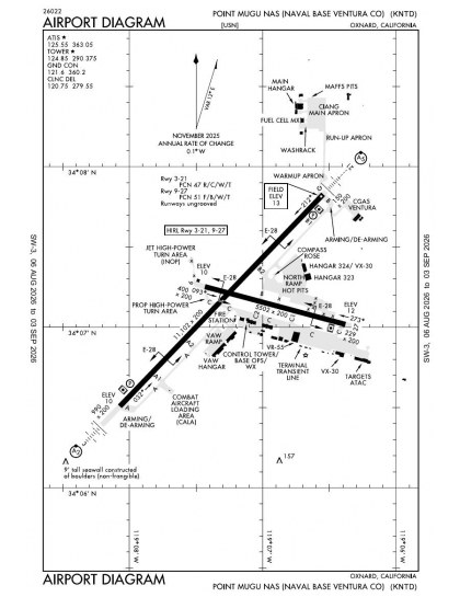
KNTD airport diagram — runways, taxiways and ramp layout
KNTD airport diagram The official FAA airport diagram — runways, taxiways, ramp layout and hold-short positions. Download PDF

7 published instrument approaches: 2 ILS approaches, 2 RNAV (GPS), serving 2 runway ends.

All 14 KNTD charts in one download Every approach, departure, arrival and minimums page for this airport, sorted into folders, as a single ZIP. Taken one at a time on the free tier, 14 charts is roughly 1 min of downloading — they queue one behind another.
PRO members only

Instrument approach procedures

ChartAmendment
HI-TACAN Z RWY 21 chart previewHI-TACAN Z RWY 21PDF
ILS OR LOC RWY 03 chart previewILS OR LOC RWY 03PDF
ILS OR LOC RWY 21 chart previewILS OR LOC RWY 21PDF
RNAV (GPS) RWY 03 chart previewRNAV (GPS) RWY 03PDF
RNAV (GPS) RWY 21 chart previewRNAV (GPS) RWY 21PDF
TACAN RWY 21 chart previewTACAN RWY 21PDF
TACAN Z RWY 03 chart previewTACAN Z RWY 03PDF

Departure procedures

ChartAmendment
DOYLE NINE chart previewDOYLE NINEPDF
SAN MARCUS ONE chart previewSAN MARCUS ONEPDF

Arrival procedures (STAR)

ChartAmendment
GUERA TWO (RNAV) chart previewGUERA TWO (RNAV)PDF
GUERA TWO (RNAV), CONT.1 chart previewGUERA TWO (RNAV), CONT.1PDF

Takeoff and alternate minimums

ChartAmendment
TAKEOFF MINIMUMS chart previewTAKEOFF MINIMUMSPDF
RADAR MINIMUMS chart previewRADAR MINIMUMSPDF

Minimums pages cover a whole volume, so the same document is shared by every airport in it.

KNTD airport information

Control tower
Yes
Attendance
All all 1500-0700z++
ARTCC
Los Angeles Center
Flight service
Prescott
NOTAM facility
NTD (NOTAM-D available)
Magnetic variation
12E
Beacon
Split-white-green (military airport), sunset to sunrise
Bottled oxygen
None
Ownership
Privately owned
Sectional
Los Angeles

From the FAA NASR 28-day subscription, cycle 6 Aug 2026.

KNTD radio frequencies

ServiceFrequencyCall sign
Tower124.85126.2Point Mugu
Ground121.6Point Mugu
Clearance delivery120.75Point Mugu
ATIS125.55Point Mugu
Approach128.65Point Mugu
Emergency121.5Point Mugu

Civil VHF frequencies from the FAA NASR 28-day subscription. Discrete sector and military frequencies are not listed.

Runways

11,102 × 200 ft03215,502 × 200 ft0927N2,000 ft
Runway layout at KNTD, drawn to scale from FAA published runway-end coordinates and true alignments. Runways served by an ILS are highlighted.
RunwayLengthWidth SurfaceLighting
03/2111,102 ft200 ftAsphalt over concreteHigh intensity
  03 44°TILS/DME · PAPI (4-box) 3° · SALSF
  21 224°TILS/DME · PAPI (4-box) 3° · MALSR approach lighting
09/275,502 ft200 ftAsphalt over concreteHigh intensity

Runway and approach-aid data from the FAA NASR 28-day subscription.

Where KNTD is

Latitude, longitude34.1192770, -119.1195890
Elevation13 ft

Paste the coordinates into a simulator’s world map to drop straight onto the field.

FAA remarks for KNTD

  • AVBL ONLY DURING HRS OF OPERATION.
  • SEE FLIP AP/1 SUPPLEMENTARY ARPT RMK AND AP/1A.
  • ALSO X7578.
  • OLS
  • SF, OLS
  • UNUSBL BYD 6 DEGS LEFT & 7 DEGS RIGHT OF CNTRLN.
  • FIRST 500 FT RWY 03 AND FIRST 4100 FT RWY 21 CONC; MIDDLE 6500 FT RWY 03/21 IS POROUS FRICTION SFC.
  • FIRST 1250 FT RWY 27 CONC; REMAINDER RWY 09/27 POROUS FRICTION SFC.
  • JASU: 3(NCPP-105) 8(A/M47A-4) 9(GTC-85).
  • FUEL: J5, J8.
  • FLUID - SP LHOX LOX.
  • OIL: O-128-148.
  • TSNT ALERT/AIR TRML: OPR 1400-0200Z++ MON-THU; 1400-0100Z++ ALTN FRI; CLSD ALTN FRI, WKEND AND HOL. TSNT ACFT LOADING/OFFLOADING REQ OUTSIDE PUBLD HRS CTC AFLD MGR 805-989-8003/4737 FOR APVL. LTD FLEET SVC (LAVATORY AVBL; NO POTABLE WATER; NO WET ICE; NO DRY ICE; NO OXY). LOX LTD. TSNT ACFT PRKG EXTREMELY LTD. MIN 24-HR PRIOR NOTICE RQRD FOR ACFT WITH ORDNANCE. ORDNANCE MUST BE SECURED BY DET PSNL OR AIRCREW PRIOR TO RFLG. NO TSNT MAINT/LTD SVC. TSNT ACFT MAINT/HGR SPACE EXTREMELY LTD TO NON-EXISTENT. NO DE-ICING AVBL.
  • RSTD: PPR FOR ALL TSNT ACFT. 72 HRS PN RQRD. ACFT THAT FAIL TO ARRIVE WI +/- 30 MIN OF ETA RISK BEING CN UNLESS PRIOR CDN/UPDATE IS MADE. SEND ALL PPR REQS VIA EMAIL TO NBVC_AFM@US.NAVY.MIL. ARPT HRS SUBJ CHG VIA NOTAM. AMC/NALO MSN RQR FLT ADVSY OR PRIOR COORD.
  • TFC PAT: REDUCED RWY SEPARATION STD IN EFF USN/USMC ACFT. RWY 21 DEP DO NOT COMMENCE TURNS TIL 500' AND 1/2 NM OFFSHORE. RWY 27 DEP DO NOT COMMENCE TURNS TIL 500'.
  • NS ABTMT - AVOID POPULATED AREAS WHEN POSSIBLE DUE TO EXTREME NOISE SENSITIVE AREA. PRO IN EFF 0400-1600Z++. EXP RWY 3 ARR AND RWY 21 DEP BTW 0400-0700Z++ JETS, AND 0600-0700Z++ ALL OTH ACFT, MON-SUN, AND FEDERAL HOL.
  • CSTMS/AG/IMG: CSTMS AVBL MON-FRI 1600-0700Z++ WITH MIN 24 HR PN. AGRICULTURE INSPN/INTL WASTE REMOVAL NOT AVBL; EXP INTL WASTE TO RMN OB TO NEXT APROP ARPT.
  • MISC - CAT E AIRSPACE EFF 0600-1400Z++.
  • CAUTION - EXTREME MID-AIR POTENTIAL DUE HI DENSITY VFR GENERAL AVN TFC IN VCNTY. CIV ARPT (CAMARILLO) 6 NM N UNCTL 0500-1500Z++ DLY. HI TERRAIN TO 1567' E OF FLD. BIRD WATCH CONDITION IS MODERATE TO SEVERE, DUE TO SEASONAL BIRD MIGRATION ANNUALLY FROM OCT 1 - APR 30. HANG GLIDER ACT VCNTY ROUND MT 4 NM NE SR-SS. ARPT PARADROP AREA ACTV DLY, 2-4 NM WEST OF FNA CRS RWY 21 BTWN 7-9 NM.
  • WKENDS, OCT-JAN, BASH SUPPORT ACT REMOVING WATERFOWL FR THE AIR IN MARSH AREAS S OF RWY 09/27 AND WI 700 FT OF RWY 21 EDGES/OVRN.
  • ANG - OPR HRS 1400-0600Z++, CLSD HOL. TSNT ALERT HRS 1500-2200Z++ MON-FRI, CLSD SAT, SUN, AND HOL. PPR RQRD FOR ALL TSNT ACFT ON CIANGS RAMP ONLY; USE DSN 893-7577/7578, C805-986-7577/7578.
  • ANG - TMPRY WAIVERS ON ANG RAMP: FIRE HYDRANT BOLLARDS EXIST ALONG THE EDGE OF THE APN; MODULAR AIRBORNE FFR SYS PIT TAXI LINES ARE NOT MKD IAW REG; PITS ARE ONLY USED DUR CONTINGENCY OPS, ALLOWING ACFT TO TAXI CLOSE TO FAC TO RELOAD RETARDANT; PAINTED TURN GUIDELINES BTN PRKG SPACES ARE NOT UNIFORM (DIST VARY FROM 160.5 FT TO 182.67 FT; CURRENT CONFIGURATION PLACES AGE EQPT BENEATH THE WG OF TURNING ACFT, WITHIN THE CLR ZONE AROUND THE PROP, AND NON-STD MARKINGS-NOSE WHEEL MARKINGS AND ACFT SPOT INDICATION.
  • BIRD/WILDLIFE AND ACFT STRIKE HAZ INFO: WILDLIFE HAZ EXISTS; PILOTS SHOULD RPT ALL BIRD OR MAMMAL SIGHTINGS TO TWR OR BOPS ON FREQ 305.6.
  • BIRD/WILDLIFE AND ACFT STRIKE HAZ INFO: DRG PHASE II, PILOTS CAN EXP BIRD WATCH COND TO BE MOD OR SEV; TKOFS/LNDGS WI 90 MIN OF OFFL SR/SS SHOULD ONLY HAPPEN IF IT IS MISSION ESNTL; AND IF POSS, TNG AND FRMN MISSIONS SHOULD AVOID TKOF/LNDG WITH 90 MIN OF THE OFFL SR/SS.
  • BIRD/WILDLIFE AND ACFT STRIKE HAZ INFO: PHASE I ALL DATES NOT DSGND AS PHASE II.
  • BIRD/WILDLIFE AND ACFT STRIKE HAZ INFO: PHASE II EFF 1 OCT THRU 15 APR; BIRD ACT IS INCRD DUR THESE MONTHS DUE TO THE MIGRATORY SEASON, THE PRI THREAT DUR THESE PDS CONSIST OF LRG QNTYS AND MORE FQT CONCENTRATION OF BIRDS IN ALL AREAS AROUND THE AFLD, AND AIRCREWS MUST BE AWARE OF HVY MIGRATORY FOWL DURG THESE TIMES.
  • BIRD WATCH COND SEVERE: WILDLIFE ACT ON OR IMT ABV THE ACTV RWY OR OTHER SPECIFIC LOC REPG HIGH POTENTIAL FOR STRIKES; SUPERVISION AND AIRCREWS MUST THOROUGHLY EVAL MISSION NEED BEFORE CONDUCTING OPNS IN AREAS UNDER COND SEVERE.
  • BIRD WATCH COND MODERATE: WILDLIFE ACT NEAR THE ACTV RWY OR OTHER SPECIFIC LOC REPG INCRD POTENTIAL FOR STRIKES; REQS INCRD VIGILANCE BY ALL AGENCIES AND SUPVRS AND CTN BY AIRCREWS.
  • BIRD WATCH COND LOW: WILDLIFE ACT ON OR AROUND THE AFLD REPG LOW POTENTIAL FOR STRIKES.
  • CAUTION: TWY E CLSD. TWY A2 OPEN TO PROP AND R/W, CLSD TO JET ENG ACFT.
  • TWY D CLSD.
  • TSNT ALERT - PRIOR CDN REQ FOR ACFT WITH ORDNANCE. ORDNANCE MUST BE SECURED BY DET PSNL OR AIRCREW PRIOR TO FUELING.
  • A-GEAR - RWY 3-21 LONG-FLD A-GEAR RIGGED; SHORT FLD DERIGGED, AVBL 15 MIN PN.
  • SERVICE: LGT - CARRIER DECK LGT AND MRKGS RWY 27; IFLOLS RWY 27. ROTG BCN NOT OPR WHEN ARPT CLSD.
  • SERVICE: FUEL - 5K GAL TRUCKS ONLY, NO HYDRANT FUELING. LARGE/HEAVY TSNT ACFT EXP RFLG DELAYS. HOT PITS NOT AVBL FOR TSNT ACFT.
  • RSTD - VTOL OPR FROM ANY RWY, TWY, APRON PROHIBITED EXC DECLARED EMERG. 180 DEG TURNS ON ASPH RWY SECTIONS PROHIBITED.
  • CAUTION - E-28 A-GEAR 25 FT FROM EDGE OF RWY, APRXLY 5 FT TALL.
  • MISC - LRG/HVY 4-ENG ACFT TAXI WITH INBOARD ENGS ONLY FOR FOD MITIGATION.
  • RSTD - CIV ACFT REQ VALID/APVD CIVIL AIRCRAFT LANDING PERMIT (CALP); FOREIGN ACFT REQ NAVY AIRCRAFT LANDING AUTHORIZATION NUMBER (NALAN); CTC AIRFIELD MGR VIA EMAIL TO NBVC_AFM@US.NAVY.MIL. NEW CALP RQRS 30 DAYS PRIOR NOTICE FOR COORD/LEGAL REVIEW.

Published verbatim from the FAA NASR subscription. Abbreviations are the FAA's own.

Instrument procedure coverage

Point Mugu NAS has approaches serving two of its four runway ends, combining ILS, localiser and RNAV (GPS) procedures. This provides both ground-based and satellite-guided options, but the coverage remains concentrated on half the available runway directions. The 11,102 ft runway is roughly twice the length of the 5,502 ft runway, making runway assignment a material distinction rather than a choice between equivalent strips.

Surrounding chart coverage

Oxnard and Camarillo have the nearest broadly comparable procedure sets, while Van Nuys and Santa Monica publish substantially larger collections; Whiteman’s coverage is notably thinner. The Los Angeles Terminal Area Chart adds detailed VFR context around the airport, while the Los Angeles Sectional places it within the wider regional picture beyond the scope of the terminal procedures.

Airports near KNTD

IDAirportCity DistanceCharts
KCMACamarilloCAMARILLO, CA6 nm N9
KOXROxnardOXNARD, CA7 nm NW11
KVNYVan NuysVAN NUYS, CA32 nm E28
KSMOSanta Monica MuniSANTA MONICA, CA34 nm E24
KWHPWhitemanLOS ANGELES, CA36 nm E6
KLAXLos Angeles IntlLOS ANGELES, CA37 nm E103
KBURBob HopeBURBANK, CA38 nm E27
KSBASanta Barbara MuniSANTA BARBARA, CA40 nm NW15

VFR charts covering KNTD

Common questions about KNTD

What charts are available for KNTD?

14 current FAA charts for Point Mugu NAS (Naval Base Ventura Co), including 7 instrument approachs, 2 departure procedures, 2 arrival procedures, 1 airport diagram. All are free to download as PDFs from this page, from the 6 August 2026 cycle.

What are the radio frequencies for KNTD?

Tower 124.85, 126.2; Ground 121.6; ATIS 125.55; Clearance delivery 120.75. Full civil VHF list, with sector notes, is in the frequencies table on this page — from the FAA NASR subscription.

How long is the runway at KNTD?

Point Mugu NAS (Naval Base Ventura Co) has 2 runways. The longest is 03/21 at 11,102 ft by 200 ft, asphalt over concrete. Full runway dimensions, lighting and approach aids are listed on this page.

Does KNTD have an ILS approach?

Yes — 2 ILS procedures are published. In total KNTD has 7 published instrument approaches, of which 2 are RNAV (GPS).

Where can I download the KNTD airport diagram?

The official FAA airport diagram for Point Mugu NAS (Naval Base Ventura Co) is free to download at the top of this page. It shows runways, taxiways, ramp layout and hold-short positions, and is reissued every 28 days.

Is KNTD a towered airport?

Yes. Point Mugu NAS (Naval Base Ventura Co) has an operating control tower, within Los Angeles Center's airspace. Tower, ground and clearance frequencies are listed on this page.

Are these KNTD charts current?

They are from the FAA cycle effective 6 August 2026, which is superseded on 3 September 2026. We publish each new cycle on its effective date. They are for flight simulation and reference only — not for real-world navigation.

Wider chart sets

Bulk archives are a PRO benefit. Individual charts are free for everyone, always.

Flying into KNTD? PRO members take all 14 charts as one ZIP instead of 14 separate downloads, at full line speed with no cap — plus every chart family archive and all 24,000+ add-ons in the library.

Go PRO

Not for navigation. For flight simulation and reference use only. Procedures are superseded on a 28-day cycle — obtain current official charts from the FAA for real-world flight.

FAA public-domain products, mirrored unmodified. Fly Away Simulation is not affiliated with or endorsed by the FAA. Chart licensing and terms.