Terminal Procedures

PAED — Elmendorf AFB

ANCHORAGE, AK · 18 FAA charts · cycle 6 Aug 2026

FAA EDFElevation 213 ft2 runwaysLongest 10,000 ftToweredFuel JP-8Volume AK-1Not for navigation
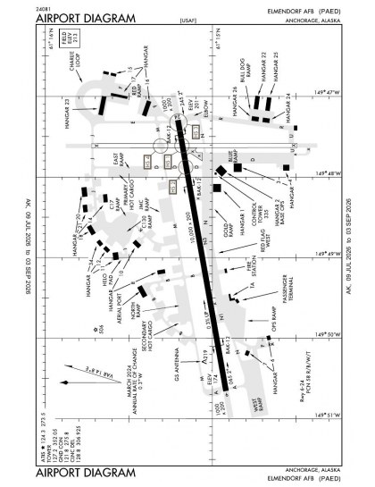
PAED airport diagram — runways, taxiways and ramp layout
PAED airport diagram The official FAA airport diagram — runways, taxiways, ramp layout and hold-short positions. Download PDF

8 published instrument approaches: 3 ILS approaches, 1 RNAV (GPS), serving 2 runway ends.

All 18 PAED charts in one download Every approach, departure, arrival and minimums page for this airport, sorted into folders, as a single ZIP. Taken one at a time on the free tier, 18 charts is roughly 2 min of downloading — they queue one behind another.
PRO members only

Instrument approach procedures

ChartAmendment
ILS X RWY 06 (SA CAT I) chart previewILS X RWY 06 (SA CAT I)PDF
ILS Y OR LOC/DME Y RWY 06 chart previewILS Y OR LOC/DME Y RWY 06PDF
ILS Z OR LOC/DME Z RWY 06 chart previewILS Z OR LOC/DME Z RWY 06PDF
RNAV (GPS) RWY 06 chart previewRNAV (GPS) RWY 06PDF
TACAN RWY 06 chart previewTACAN RWY 06PDF
TACAN Y RWY 16 chart previewTACAN Y RWY 16PDF
TACAN Z RWY 16 chart previewTACAN Z RWY 16PDF
TACAN-A chart previewTACAN-APDF

Departure procedures

ChartAmendment
EEEGL SIX chart previewEEEGL SIXPDF
ELMENDORF FOUR (RNAV) chart previewELMENDORF FOUR (RNAV)PDF
YUKLA THREE chart previewYUKLA THREEPDF

Arrival procedures (STAR)

ChartAmendment
GRUUB ONE (RNAV) chart previewGRUUB ONE (RNAV)PDF
GRUUB ONE (RNAV), CONT.1 chart previewGRUUB ONE (RNAV), CONT.1PDF
JINXX ONE (RNAV) chart previewJINXX ONE (RNAV)PDF

Takeoff and alternate minimums

ChartAmendment
TAKEOFF MINIMUMS chart previewTAKEOFF MINIMUMSPDF
RADAR MINIMUMS chart previewRADAR MINIMUMSPDF

Minimums pages cover a whole volume, so the same document is shared by every airport in it.

Hot spots

ChartAmendment
HOT SPOT chart previewHOT SPOTPDF

PAED airport information

Control tower
Yes
Attendance
Continuous
ARTCC
Anchorage Center
Flight service
Kenai
NOTAM facility
EDF (NOTAM-D available)
Magnetic variation
15E
Beacon
White-green (lighted land airport), sunset to sunrise
Wind indicator
Yes
Fuel
JP-8
Customs
Landing rights airport
Activated
March 1949
Ownership
Privately owned
Sectional
Anchorage
Last FAA inspection
1979-07-23

From the FAA NASR 28-day subscription, cycle 6 Aug 2026.

PAED radio frequencies

ServiceFrequencyCall sign
Tower127.2Elmendorf
Ground121.8Elmendorf
Clearance delivery128.8Elmendorf
ATIS124.3Elmendorf
Approach118.6134.1Elmendorf

Civil VHF frequencies from the FAA NASR 28-day subscription. Discrete sector and military frequencies are not listed.

Runways

10,000 × 200 ft06247,493 × 150 ft1634N3,000 ft
Runway layout at PAED, drawn to scale from FAA published runway-end coordinates and true alignments. Runways served by an ILS are highlighted.
RunwayLengthWidth SurfaceLighting
06/2410,000 ft200 ftAsphaltHigh intensity
  06 80°TILS · PAPI (4-box) 3° · ALSF-1 approach lighting
  24 260°TPAPI (4-box) 3° · right-hand circuit
16/347,493 ft150 ftAsphaltHigh intensity
  16 180°TPAPI (4-box) 3°
  34 360°TPAPI (4-box) 3° · right-hand circuit

Runway and approach-aid data from the FAA NASR 28-day subscription.

Where PAED is

Latitude, longitude61.2513530, -149.8065260
Elevation213 ft
From Anchorage3 nm NE

Paste the coordinates into a simulator’s world map to drop straight onto the field.

FAA remarks for PAED

  • ARFF FAA INDEX D/ CAT 8/10.
  • TPA: OVHD 1700 FT MSL, CONVENTIONAL 1200 FT MSL, HEL/LGT 800 FT MSL.
  • CTN: 3/4 IN CNTRLN SFC DEPRESSION 19 FT LONG 487 FT FM RWY 24 END. 180 DEG TURNS BTN TWY D & RWY INTXN NA.
  • CLSD INDEFLY.
  • PAPI UNUSBL BYD 8 DEGS EITHER SIDE OF CNTRLN.
  • PAPI UNUSBL BYD 7 DEG RIGHT OF CNTRLN.
  • HGR SPACE & WARM STORAGE LMTD OCT-MAY.
  • PREVENTIVE MAINT: TACAN WED & FRI 1600-1700Z; ILS TUE & THU 1500-1700Z; PAR SAT-SUN 1800-2000Z; ASR SAT-SUN 2000-2200.
  • QUIET HR 0630-1400Z WKDAY; 0630-1600Z WKEND & HOL; AMC ACFT EXEMPT.
  • DURG VMC DEP/MISSED APCHS/GO AROUNDS; ACFT SHALL MNTN AT OR BLW 1200 FT MLS UNTIL DEP END OF RWY 06.
  • FTR ARR EXP RDCD SEPN; SAME TYPE ACFT & DALGT 3000 FT; DISSIMILAR ACFT &/OR NGT 6000 FT; AHD/BHND FRMN LDG 6000 FT.
  • CTN: RIDGE EXTDG FM 260-020 DEG 1-2 MI FM TWR PREVENTS FOG OBS OVR KNIK ARM. VIS MAY DROP RAPIDLY AS FOG POURS OVR RIDGE.
  • MNTN IDLE PWR ON OUTBOARD ENG DURG TAX.
  • HOLD SHORT LINE SIGNS NA ON INTERSECTING RWYS.
  • FQT ACT IN R2203; WHEN UNA TO AVOID CTC ATCT.
  • SPEC ATC RULES FAR PART 93; SEE REG NOTICES IN SUPPL.
  • LMTD WKEND MAINT SVC.
  • JOAP, JOINT OIL ANALYSIS PROGRAM AVBL. LHNIT, LOW & HIGH PRES NITROGEN SVCG AVBL. JOAP & LOW & HIGH PRES NITROGEN SVC DURG DUTY HOURS; AFT HR ON REQ. DE-ICE, TYPE 1 DE-ICE LIFTOFF P-88; TYPE 4 ANTI-ICE CLARIANT SAFEWING MP-LAUNCH.
  • CHANGE JET ACFT STARTING UNITS (JASU) TO, (A/M32A-86), MC-1A), (MC-2A), (AM32A-60A). (AM32-95)150 +/-5 LBS/MIN (2055 +/-68CFM) AT 51 +/-02 PSIA. LASS 150 +/-5 LBS/MIN @ 49 +/-2 PSIA.
  • OIL: O-123, O-128, O-133, O-148, O-156, JOAP.
  • FLUID: PRESAIR & NITROGEN-LHNIT.
  • IFF SVC AVBL.
  • NVD OPS RWY 06/24 MON-FRI 0400-1000Z++.
  • CTN: IFR OPS BTW 1500-2000 MSL FM BGQ 092/10 INTO R2203-EDF 320/07 INVOF BIG LAKE, PALMER, BIRCHWOOD, GOOSEBAY & WASILLA AK; MON-SAT 0300-0800Z++ & TUES & THU 1800-2200Z++.
  • DV SPOTS 1 & 3 LMTD TO WINGSPANS 136 FT OR LESS.
  • CTN: UNLGT TRRN 0 FT AGL/341 FT MSL 1909 FT PRIOR TO THR 1914 FT R OF COURSE.
  • TWY N2 & N5 CLSD.
  • AIRFIELD MGMT COMSEC STORAGE NA; COMSEC STORAGE - COMMAND POST D317-552-3000.
  • CUST & AG INSP RQR TO CTC BASE OPS AT LEAST 90 MIN PRIOR TO ARR.
  • ALL TSNT PPR - AMGR C907-552-2107/D552-2107.
  • SUBMIT PPR FORM IN THE PAED GIANT REPORT STIF TO BASEOPS3@US.AF.MIL NO EARLIER THAN 30 DAYS & NO LATER THAN 48 HR PRIOR TO ARR. PPR ISSUED NO EARLIER THAN 7 DAYS PRIOR TO ARR.
  • NORMAL BARRIER CONFIGURATION DURG FTR FLY WINDOW LEAVES 5675 FT BTW CABLES ON RWY 06/24, OUTSIDE OF FTR FLY WINDOWS THERE IS 7658 FT BTW CABLES.
  • ACFT REQ CABLES DE-RIGGED CTC BASE OPS 24 HR PRIOR TO ARR OR REQ PRIOR TO PPR ISSUED.
  • AMC ASGND MSN ACFT EXP MAINT SVC BY 732 AMS.
  • LCL SORTIES OR DEPLOYING TO OR OUT OF ELMENDORF AFB MUST HAVE MAINT PSNL REQ TO CMPLT OPS; INCLG DE-ICE PSNL DURG COLD WX. DEPLOYED ACFT TRANS ALERT SUPPORT NA BYD INITIAL BLOCK IN.
  • EXC ELMENDORF MAJCOM EXER, DEPLOYED OR STAGED UNITS CTC 3 WG SKED D317-552-2406 OR C907-552-2406 ASAP FOR LCL AREA BRIEFING, MAINT SPONSORSHIP & VISITING UNIT SMTN REQ FORM FOR 3 OG/CC APVL PRIOR TO LCL OPS.
  • TRAN ALERT SVC LMTD TO POL SVC, INTAKE, MAGNETIC CHIP DETECTOR & EOR INSP.
  • NON-AMC RQRG 732 AMS MAINT SVC EXP PSBL DELAY.
  • RCR/RSC & FLD RCR - ATCT. RWY COND CODE & FICON NOT RPTD.
  • H24 WX - D317-552-4903/4397/C907-552-4903/4397.

Published verbatim from the FAA NASR subscription. Abbreviations are the FAA's own.

Approach and runway coverage

Elmendorf’s instrument coverage is concentrated on two of its four runway ends. The mix includes three ILS procedures, two localiser procedures and one RNAV (GPS) approach, giving the served ends both ground-based and satellite-based options rather than spreading coverage across every direction. Its two runways provide distinct alignments, while the 2,507 ft difference between them makes runway selection materially affect the available take-off and landing distance.

Chart context

Ted Stevens Anchorage International has substantially broader procedure coverage nearby, while Merrill Field’s set is thinner but still larger than those for Bryant AAF, Big Lake and Lake Hood. The Anchorage-Fairbanks Terminal Area Chart adds detailed terminal-area context; the Anchorage and Seward sectionals extend that VFR picture across a broader area than the airport-specific instrument procedures.

Airports near PAED

IDAirportCity DistanceCharts
PAMRMerrill FldANCHORAGE, AK3 nm SW8
PAFRBryant AAFFORT RICHARDSON (ANCHORAGE), AK5 nm E4
PALHLake HoodANCHORAGE, AK6 nm SW1
PANCTed Stevens Anchorage IntlANCHORAGE, AK7 nm SW33
PAGQBig LakeBIG LAKE, AK17 nm N4
PAWSWasillaWASILLA, AK21 nm N4
PAAQWarren "bud" Woods Palmer MuniPALMER, AK29 nm NE7
PAUOWillowWILLOW, AK31 nm N4

VFR charts covering PAED

Common questions about PAED

What charts are available for PAED?

18 current FAA charts for Elmendorf AFB, including 8 instrument approachs, 3 departure procedures, 3 arrival procedures, 1 airport diagram. All are free to download as PDFs from this page, from the 6 August 2026 cycle.

What are the radio frequencies for PAED?

Tower 127.2; Ground 121.8; ATIS 124.3; Clearance delivery 128.8. Full civil VHF list, with sector notes, is in the frequencies table on this page — from the FAA NASR subscription.

How long is the runway at PAED?

Elmendorf AFB has 2 runways. The longest is 06/24 at 10,000 ft by 200 ft, asphalt. Full runway dimensions, lighting and approach aids are listed on this page.

Does PAED have an ILS approach?

Yes — 3 ILS procedures are published. In total PAED has 8 published instrument approaches, of which 1 are RNAV (GPS).

Where can I download the PAED airport diagram?

The official FAA airport diagram for Elmendorf AFB is free to download at the top of this page. It shows runways, taxiways, ramp layout and hold-short positions, and is reissued every 28 days.

Is PAED a towered airport?

Yes. Elmendorf AFB has an operating control tower, within Anchorage Center's airspace. Tower, ground and clearance frequencies are listed on this page.

Are these PAED charts current?

They are from the FAA cycle effective 6 August 2026, which is superseded on 3 September 2026. We publish each new cycle on its effective date. They are for flight simulation and reference only — not for real-world navigation.

Wider chart sets

Bulk archives are a PRO benefit. Individual charts are free for everyone, always.

Flying into PAED? PRO members take all 18 charts as one ZIP instead of 18 separate downloads, at full line speed with no cap — plus every chart family archive and all 24,000+ add-ons in the library.

Go PRO

Not for navigation. For flight simulation and reference use only. Procedures are superseded on a 28-day cycle — obtain current official charts from the FAA for real-world flight.

FAA public-domain products, mirrored unmodified. Fly Away Simulation is not affiliated with or endorsed by the FAA. Chart licensing and terms.