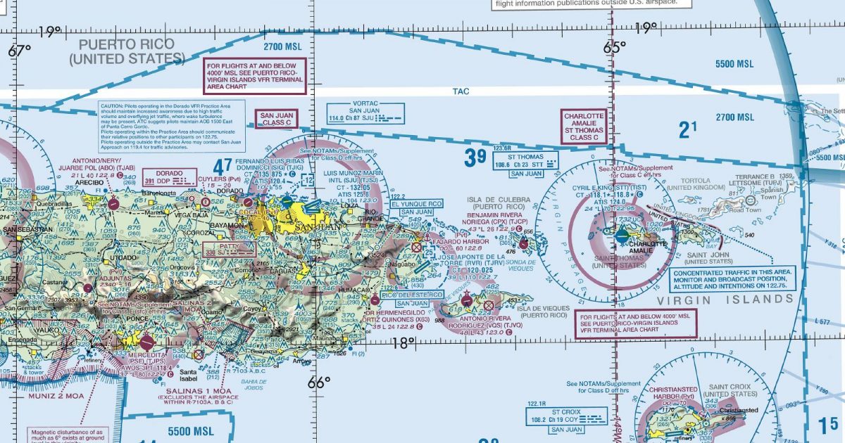
Official FAA digital chart — free GeoTIFF and PDF download
| Format | What you get | Size | |
|---|---|---|---|
| GeoTIFF | Georeferenced raster at 300 dpi, with world file and FGDC metadata | 21.9 MB | Download |
| Print-ready chart, no georeferencing | 46.4 MB | Download |
Not for navigation. For flight simulation and reference use only. Check the effective dates above, and obtain official charts from the FAA for real-world flight.

These are big files. This chart alone is 46.4 MB. Guest downloads are rate limited; PRO members get full-speed, unthrottled downloads across every chart and all 24,000+ add-ons in the library.
Go PROHispaniola and Puerto Rico anchor this sheet, with coverage extending north towards the Turks and Caicos and the southern Bahamas, then east and south along the Virgin Islands and Lesser Antilles. The island chain continues through the Leeward and Windward groups towards Saint Vincent and the northern Grenadines.
Flying here shifts repeatedly between substantial, mountainous islands and much smaller coastal or volcanic landforms separated by open sea. Hispaniola provides the largest and most rugged terrain, while Puerto Rico forms another broad landmass before the route pattern breaks into closely spaced island groups. Farther south, the curved Lesser Antilles chain offers a clear geographical thread across a largely maritime chart.
The western edge meets Caribbean 1, supporting routes continuing towards Cuba, Jamaica and the western Caribbean without forcing this eastern sheet beyond its natural island-chain focus.
| ID | Airport | City | Elev | Rwys | Longest |
|---|---|---|---|---|---|
| TJBQ BQN | Rafael Hernandez | AGUADILLA, PR | 237 ft | 1 | 11,702 ft |
| TJRV RVR | Jose Aponte De La Torre | CEIBA, PR | 38 ft | 1 | 11,000 ft |
| TJSJ SJU | Luis Munoz Marin Intl | SAN JUAN, PR | 9 ft | 2 | 10,400 ft |
| TISX STX | Henry E Rohlsen | CHRISTIANSTED, VI | 73 ft | 1 | 10,002 ft |
| TJPS PSE | Mercedita | PONCE, PR | 36 ft | 1 | 8,002 ft |
| MBPV | Providenciales Intl | PROVIDENCIALES | 13 ft | 1 | 7,598 ft |
| TNCM | Princess Juliana Intl | PHILIPSBURG | 14 ft | 1 | 7,546 ft |
| MYIG | Matthew Town | MATTHEW TOWN | 17 ft | 1 | 7,020 ft |
| TIST STT | Cyril E King | CHARLOTTE AMALIE, VI | 23 ft | 1 | 7,000 ft |
| MBGT | Jags Mccartney Intl | COCKBURN TOWN | 11 ft | 1 | 6,368 ft |
| MBSC | South Caicos Intl | COCKBURN HARBOUR | 9 ft | 1 | 6,007 ft |
| TJIG SIG | Fernando Luis Ribas Dominicci | SAN JUAN, PR | 9 ft | 1 | 5,539 ft |
| TQPF | Clayton J Lloyd Intl | THE VALLEY | 127 ft | 1 | 5,462 ft |
| TJMZ MAZ | Eugenio Maria De Hostos | MAYAGUEZ, PR | 28 ft | 1 | 4,998 ft |
| TUPJ | Terrance B Lettsome Intl | ROADTOWN | 16 ft | 1 | 4,645 ft |
| TJVQ VQS | Antonio Rivera Rodriguez | ISLA DE VIEQUES, PR | 48 ft | 1 | 4,294 ft |
| TNCE | F D Roosevelt | ORANJESTAD | 129 ft | 1 | 4,265 ft |
| MBNC | North Caicos Intl | BOTTLE CREEK AND WHITBY | 12 ft | 1 | 4,193 ft |
| TJAB ABO | Antonio/Nery/Juarbe Pol | ARECIBO, PR | 20 ft | 1 | 3,963 ft |
| TFFG | Grand Case | GRAND CASE | 20 ft | 1 | 3,937 ft |
| TJCP CPX | Benjamin Rivera Noriega | ISLA DE CULEBRA, PR | 42 ft | 1 | 2,596 ft |
| X63 | Dr Hermenegildo Ortiz Quinones | HUMACAO, PR | 34 ft | 1 | 2,457 ft |
22 public-use airports within this chart's coverage, ordered by runway length. A further 6 private and restricted landing facilities are not listed. Source: FAA NASR 28-day subscription.
Approach plates and airport diagrams for every airport in the states this sheet covers:
It spans 12.7°N to 22.3°N and 74.9°W to 60.2°W. Airports on the sheet fall within Puerto Rico and U.S. Virgin Islands. The full list of public-use airports within its coverage is on this page.
Take the GeoTIFF if you are loading the chart into moving-map software or a flight planner — it is georeferenced, so the software can place it correctly on a map, and it ships with a world file and FGDC metadata at 300 dpi (21.9 MB). Take the PDF to print it or read it on a second screen (46.4 MB); it is the same chart without georeferencing.
This is the FAA edition effective 3 September 2026, which is superseded on 29 October 2026. Visual charts are reissued every 56 days and we publish each new edition on the day it takes effect. It is for flight simulation and reference only — not for real-world navigation.
Caribbean 1 to the west. Each is linked from this page, so a route running off one edge can be continued on the next sheet.
Yes, with no account required. FAA charts are United States Government works and are not subject to copyright protection in the US under 17 U.S.C. § 105. Guest downloads are speed-capped, so a sheet this size takes a while; PRO members download at full line speed and can take the whole family as one archive.

FAA public-domain products, mirrored unmodified. Fly Away Simulation is not affiliated with or endorsed by the FAA. Chart licensing and terms.

