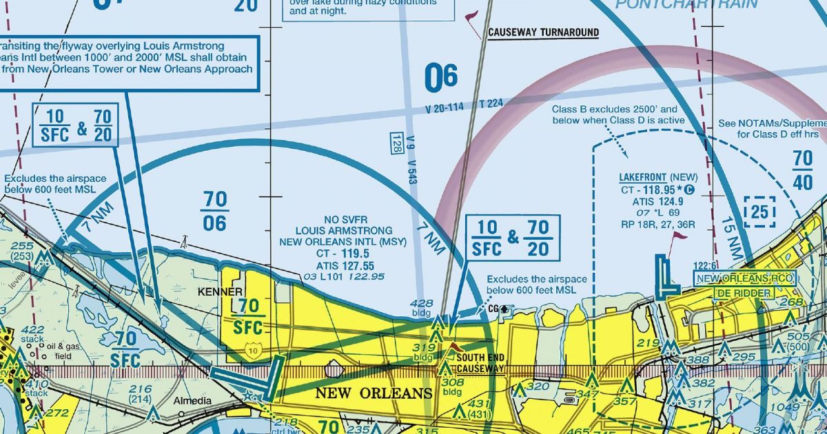
Official FAA digital chart — free GeoTIFF and PDF download
| Format | What you get | Size | |
|---|---|---|---|
| GeoTIFF | Georeferenced raster at 300 dpi, with world file and FGDC metadata | 20.7 MB | Download |
| Print-ready chart, no georeferencing | 42.8 MB | Download |
Not for navigation. For flight simulation and reference use only. Check the effective dates above, and obtain official charts from the FAA for real-world flight.

These are big files. This chart alone is 42.8 MB. Guest downloads are rate limited; PRO members get full-speed, unthrottled downloads across every chart and all 24,000+ add-ons in the library.
Go PROThe lower Mississippi corridor, New Orleans and the broad waters of Lake Pontchartrain form the centre of this sheet. Coverage extends west beyond Baton Rouge, north into the wooded country approaching southern Mississippi, and east towards the Pearl River. To the south, the chart reaches across Barataria Bay, fragmented coastal marshes and the northern Gulf of Mexico.
The landscape is overwhelmingly low and flat, but far from featureless. River bends, lakes, canals, bays and broken wetland shorelines give the area its distinctive visual structure. The contrast between dense urban development, engineered waterways and open marsh makes this a particularly varied terminal region despite the absence of mountainous terrain.
The Terminal Area Chart presents the New Orleans region at a more detailed scale suited to close study of the metropolitan area and its surrounding waterways. The corresponding Sectional Aeronautical Chart places the same ground within a broader regional setting, making it the more useful companion when a simulated route continues well beyond south-eastern Louisiana.
| ID | Airport | City | Elev | Rwys | Longest |
|---|---|---|---|---|---|
| KMSY MSY | Louis Armstrong New Orleans Intl | NEW ORLEANS, LA | 3 ft | 4 | 10,104 ft |
| KBTR BTR | Baton Rouge Metro, Ryan Fld | BATON ROUGE, LA | 69 ft | 3 | 7,500 ft |
| KNEW NEW | Lakefront | NEW ORLEANS, LA | 7 ft | 3 | 6,879 ft |
| KHUM HUM | Houma-Terrebonne | HOUMA, LA | 8 ft | 2 | 6,509 ft |
| KHDC HDC | Hammond Northshore Rgnl | HAMMOND, LA | 46 ft | 2 | 6,502 ft |
| KPTN PTN | Harry P Williams Meml | PATTERSON, LA | 8 ft | 2 | 5,399 ft |
| KAPS APS | Port Of South Louisiana Exec Rgnl | RESERVE, LA | 6 ft | 1 | 5,151 ft |
| KREG REG | Louisiana Rgnl | GONZALES, LA | 14 ft | 1 | 5,003 ft |
| KASD ASD | Slidell | SLIDELL, LA | 28 ft | 1 | 5,002 ft |
| KMJD MJD | Picayune Muni | PICAYUNE, MS | 55 ft | 1 | 5,000 ft |
| L31 | St Tammany Rgnl | COVINGTON, LA | 37 ft | 1 | 3,004 ft |
| L83 | Thibodaux Muni | THIBODAUX, LA | 9 ft | 1 | 2,999 ft |
12 public-use airports within this chart's coverage, ordered by runway length. A further 33 private and restricted landing facilities are not listed. Source: FAA NASR 28-day subscription.
Approach plates and airport diagrams for every airport in the states this sheet covers:
It spans 29.5°N to 30.7°N and 91.6°W to 89.6°W. Airports on the sheet fall within Louisiana and Mississippi. The full list of public-use airports within its coverage is on this page.
Take the GeoTIFF if you are loading the chart into moving-map software or a flight planner — it is georeferenced, so the software can place it correctly on a map, and it ships with a world file and FGDC metadata at 300 dpi (20.7 MB). Take the PDF to print it or read it on a second screen (42.8 MB); it is the same chart without georeferencing.
This is the FAA edition effective 3 September 2026, which is superseded on 29 October 2026. Visual charts are reissued every 56 days and we publish each new edition on the day it takes effect. It is for flight simulation and reference only — not for real-world navigation.
Yes, with no account required. FAA charts are United States Government works and are not subject to copyright protection in the US under 17 U.S.C. § 105. Guest downloads are speed-capped, so a sheet this size takes a while; PRO members download at full line speed and can take the whole family as one archive.

FAA public-domain products, mirrored unmodified. Fly Away Simulation is not affiliated with or endorsed by the FAA. Chart licensing and terms.

