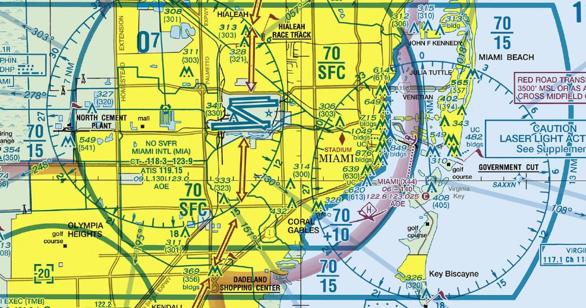
Official FAA digital chart — free GeoTIFF and PDF download
| Format | What you get | Size | |
|---|---|---|---|
| GeoTIFF | Georeferenced raster at 300 dpi, with world file and FGDC metadata | 28.0 MB | Download |
| Print-ready chart, no georeferencing | 56.1 MB | Download |
Not for navigation. For flight simulation and reference use only. Check the effective dates above, and obtain official charts from the FAA for real-world flight.

These are big files. This chart alone is 56.1 MB. Guest downloads are rate limited; PRO members get full-speed, unthrottled downloads across every chart and all 24,000+ add-ons in the library.
Go PROMiami’s Atlantic shoreline, Biscayne Bay and the eastern Everglades sit at the heart of this sheet. Coverage runs north through the Fort Lauderdale and Palm Beach corridor, south to the upper Florida Keys, and west across the peninsula to the Gulf coast around Naples. It also extends well offshore into the Atlantic. That footprint brings together a dense coastal conurbation, low-lying wetlands, long shorelines and substantial stretches of open water—an unusually varied setting within a compact South Florida area.
The Terminal Area Chart concentrates its scale on the Miami region, making it the focused companion to the Sectional Aeronautical Chart covering the same ground. The sectional supplies broader regional continuity across South Florida, while this sheet devotes its frame to the metropolitan corridor, the Everglades, the Keys and the adjoining waters. It is self-contained rather than part of a same-type adjoining-sheet sequence, so its edges do not lead directly onto another Terminal Area Chart.
| ID | Airport | City | Elev | Rwys | Longest |
|---|---|---|---|---|---|
| KMIA MIA | Miami Intl | MIAMI, FL | 9 ft | 4 | 13,016 ft |
| KTNT TNT | Dade-Collier Training And Transition | MIAMI, FL | 12 ft | 1 | 10,499 ft |
| KDJT DJT | President Donald J Trump Intl | WEST PALM BEACH, FL | 19 ft | 3 | 10,001 ft |
| KFLL FLL | Fort Lauderdale/Hollywood Intl | FORT LAUDERDALE, FL | 65 ft | 2 | 9,000 ft |
| KOPF OPF | Miami-Opa Locka Exec | MIAMI, FL | 8 ft | 3 | 8,002 ft |
| KBCT BCT | Boca Raton | BOCA RATON, FL | 12 ft | 1 | 6,276 ft |
| KFXE FXE | Fort Lauderdale Exec | FORT LAUDERDALE, FL | 13 ft | 2 | 6,002 ft |
| KTMB TMB | Miami Exec | MIAMI, FL | 10 ft | 4 | 6,000 ft |
| 2IS | Airglades | CLEWISTON, FL | 20 ft | 1 | 5,902 ft |
| X14 | La Belle Muni | LA BELLE, FL | 20 ft | 1 | 5,254 ft |
| KIMM IMM | Immokalee Rgnl | IMMOKALEE, FL | 37 ft | 2 | 5,000 ft |
| KPMP PMP | Pompano Beach Airpark | POMPANO BEACH, FL | 19 ft | 3 | 4,918 ft |
| X51 | Miami Homestead General Aviation | HOMESTEAD, FL | 7 ft | 3 | 4,001 ft |
| KLNA LNA | Palm Beach County Park | WEST PALM BEACH, FL | 14 ft | 3 | 3,489 ft |
| KHWO HWO | North Perry | HOLLYWOOD, FL | 8 ft | 4 | 3,463 ft |
| X10 | Belle Glade State Muni | BELLE GLADE, FL | 10 ft | 1 | 3,449 ft |
| X01 | Everglades Airpark | EVERGLADES CITY, FL | 4 ft | 1 | 2,400 ft |
17 public-use airports within this chart's coverage, ordered by runway length. A further 26 private and restricted landing facilities are not listed. Source: FAA NASR 28-day subscription.
Approach plates and airport diagrams for every airport in the states this sheet covers:
It spans 25.1°N to 26.8°N and 81.5°W to 79.3°W. Airports on the sheet fall within Florida. The full list of public-use airports within its coverage is on this page.
Take the GeoTIFF if you are loading the chart into moving-map software or a flight planner — it is georeferenced, so the software can place it correctly on a map, and it ships with a world file and FGDC metadata at 300 dpi (28.0 MB). Take the PDF to print it or read it on a second screen (56.1 MB); it is the same chart without georeferencing.
This is the FAA edition effective 3 September 2026, which is superseded on 29 October 2026. Visual charts are reissued every 56 days and we publish each new edition on the day it takes effect. It is for flight simulation and reference only — not for real-world navigation.
Yes, with no account required. FAA charts are United States Government works and are not subject to copyright protection in the US under 17 U.S.C. § 105. Guest downloads are speed-capped, so a sheet this size takes a while; PRO members download at full line speed and can take the whole family as one archive.

FAA public-domain products, mirrored unmodified. Fly Away Simulation is not affiliated with or endorsed by the FAA. Chart licensing and terms.

